Where is the largest Jiangxin Island in the Chongqing section of the Yangtze River?
Where is the largest dammed lake in Chongqing located?
Which is the highest peak in Chongqing?
In this book, you can find the answer.
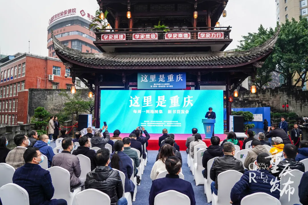
The scene of the event
On the morning of December 11th, the "Here is Chongqing" - Chongqing Geography and Culture Theme Exhibition and the launch ceremony of the new book "Here is Chongqing - Atlas of Maps every Monday" were held in Tongyuanmen City Wall Relic Park, Qixinggang Street, Yuzhong District, Chongqing.
The event was guided by the Publicity Department of Chongqing Municipal Party Committee and Chongqing Municipal Bureau of Planning and Natural Resources, and co-organized by Chongqing Geographic Information and Remote Sensing Application Center and Chongqing Foreign Cultural Exchange Association.
Map version of the "Chongqing Encyclopedia"
A selection of 80 topics and 100 maps are included
"In 2013, we began to do this special planning of 'Weekly Chart', only the beginning, not the end. If you are not careful, you will do it for 8 years. Holding the new book in his hand, Zhang Haipeng, director of the 824 Research Institute of the Chongqing Geographic Information and Remote Sensing Application Center, was full of emotions.
"This is a comprehensive urban reader that deconstructs Chongqing from a geographical perspective." As the deputy editor-in-chief of "Here is Chongqing - Weekly Map Atlas", Zhang Haipeng introduced that the whole book brings together more than 380 issues and selects 80 special topics "Weekly Map", "Through this book, people can deeply understand Chongqing and enhance cultural self-confidence; they can also fully understand Chongqing, which is a city with more than hot pot, small noodles and Internet celebrity punch points." ”
Video loading...
Video: Bu Vision/Wu Wangyang
The entire atlas contains 100 maps, 300 hand-drawn illustrations, and more than 50,000 interpretation texts, deconstructing a complete Chongqing with three chapters: landscape, culture and life.

"How many mountains are there in Chongqing?" Map interpretation
● Landscape Chapter Starting from special topics such as mountains, rivers, and landforms, we will interpret in detail the Bayu land that nurtures the natural beauty of landscapes and rivers.
Here, through the most Chongqing landscape names, you will glimpse that the genes of Chongqing people have long been written with landscape feelings.
Map interpretation of "famous towns and villages"
● Culture From the perspective of history, style, taste, inheritance, etc., it tells about the regional cultural phenomena derived from the people of Chongqing in the process of living in harmony with nature.
Here, you will feel the heroism of Chongqing, in ancient times, there were Ba Manzi who gave his head for a city pool, there was a fishing city that dared to teach "God to fold the whip", and there were hongyan children who threw their heads and spilled blood.
Map interpretation of "Mangsang Watermelon"
● Life Chapter Taking the twenty-four solar terms as the "scripture" and the citizens' life as the "latitude", integrating landscape, humanities and meteorology, it reflects the various forms of life of Chongqing people such as spring flower appreciation, summer cooling, autumn fruit picking, and winter snow appreciation.
Here, you will experience the life of Chongqing full of fireworks, the rainy season takes you to see the sea of clouds churning, the sting season takes you to see the mountain flowers, the valley rainy season takes you to pick tea and fruit, and the summer solstice takes you to camp and camp...
"This is Chongqing - Atlas of Weekly Maps"
How much do you know about Chongqing geography?
"A lot of the content is the team step by step"
"A lot of the content in the book is our professional team climbing mountains and wading through the water, step by step," Zhang Haipeng said of this, and threw out a cold knowledge: Do you know where the highest peak in the central urban area of Chongqing is located?
In the minds of many elderly people in Chongqing, the highest peak in the central urban area is either the Beibei Jinyun Mountain or the South Mountain on the south bank.
However, according to data released by the former State Bureau of Surveying and Mapping in 2009, the altitude of Jinyun Mountain's highest peak, Qizikou, is 950.3 meters, which is far from the "highest".
Zhang Haipeng tells the story behind the atlas
"In 2016, after measurement by the relevant team, the large sand soil liangzi located at the junction of Cizhu Town in Yubei District of the central urban area, Linshui County and Huaying City in Sichuan Province was determined to be the highest peak in the central urban area of Chongqing." Zhang Haipeng introduced that compared with jinyun mountain, Nanshan, which are well-known famous mountains, the big sand and soil beams can be described as lonely and nameless.
"In order to strengthen the professionalism of the contents of the book, our team visited in person." Zhang Haipeng said that at that time, the technical staff found through analysis and calculation that many peaks in the Huaying Mountain area in the northern part of the central city were more than 1200 meters above sea level, and finally based on the analysis and search of aerial photogrammetry data of the 1:5000 scale topographic map, the peak was located at an altitude of about 1421.4 meters.
Citizens watching the exhibition
The theme exhibition is online
The exhibition will be toured in the form of "board drifting"
As an urban culture book that tells the story of Chongqing from a geographical perspective and tells the story of Chongqing in a geographical way, this book has also been widely affirmed by people in the industry.
Wang Jiayao, an academician of the Chinese Academy of Engineering, said that as a map work that deeply excavates and comprehensively reflects the regional culture of Chongqing, this book will continue to enhance Chongqing's cultural soft power, become a sharp weapon to "tell the story of Chongqing well and spread the voice of Chongqing", build an image and self-confidence for the outside of the city, let outsiders know More about Chongqing, and let Chongqing people love Chongqing more.
"In this book, I found Zhiyin." Professor Zhou Yong, president of the Chongqing Local History Research Association, said that Chongqing is this community of life of "mountains, waters and cities". "Today, this 'city of rivers and mountains' has its own new city tree and new family tree."
After this ceremony, "This is Chongqing" - Chongqing Geography and Culture Theme Exhibition was also officially launched.
The exhibition selects part of the new book "Here is Chongqing - Atlas of Maps every Monday", and through rich and vivid and intuitive graphic forms, shows how many mountains there are in Chongqing, how many rivers in Chongqing know, the most beautiful place names of Chongqing, the twelve scenic spots of Bayu, special local cuisine and other popular content.
The first exhibition of the exhibition was held from December 11 to 19 in the Tongyuanmen City Wall Ruins Park in Yuzhong District. After the first exhibition, the theme exhibition will be carried out in the form of "exhibition board rafting" in the Chongqing Map Culture Center and some districts and counties.
At the same time, "Here is Chongqing - Weekly Map Atlas" will be sold offline at the Chongqing Geographic Information and Remote Sensing Application Center and the Junge Bookstore, and will be launched on Tmall, Youzan and other online platforms simultaneously.
Source: Chongqing Release
Text: Yao Yu
Photo: Wu Wangyang