The version displayed this time is about equal to the mass production version delivered to users. Compared to its debut in April 2020, the current version has a very high maturity and has experienced better than other models experienced by Super Out of the Box.
If you want to watch the full video of the experience process, you can pay attention to the B station account "Super Out-of-Box BiggerBox" to view the content of the latest issue.
In addition to the highlights of the experience summarized in the video, there are other known information to share with you:
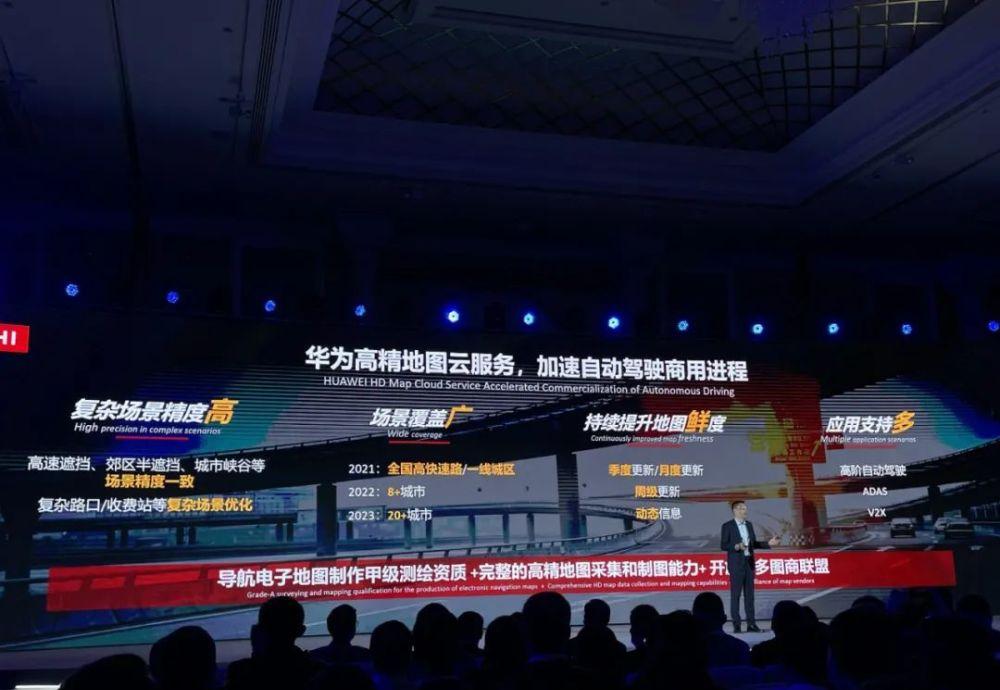
Landing cities are subject to high-precision maps
Since the ADS function needs to be enabled in the area covered by the HD map, the landing will be affected by the coverage of the HD map.
Huawei has Grade A surveying and mapping qualifications, and has completed the coverage of high-precision maps of national highways, and the urban road plan in 2022 is to cover 6 cities including Shanghai, Beijing, Shenzhen, and Suzhou, and expand to 20 cities across the country in 2023.
Urban high-precision maps have higher requirements for freshness, and it is very difficult to achieve national high-precision map collection coverage while taking into account the frequency of map updates, and Huawei is also advocating the establishment of map merchant alliances to share resources.
AutoNavi's approach is to provide a visual high-precision map of urban roads, which can be updated once a day, and the city NGP of Xiaopeng P5 uses the map.
However, there is no more information on whether visual high-definition maps use crowdsourced data collection, and the feasibility of daily updates under regulatory supervision. As for whether the regulations will adjust the supervision of the collection and release of high-precision maps, it is still unknown.
In addition, it is interesting that since Huawei itself is a map provider and a developer of the ADS full stack, it can use high-precision map data more flexibly.
For example, unlike Xiaopeng NGP and the ideal ONE NOA, Huawei ADS did not replace the central control map display in the Pilot state with a high-precision map, but put the high-precision map and real-time modeling information into the visual interface of the instrument screen.

If you want to visualize the high-definition map, you need to organize the map information. Huawei ADS removes the model of gantry, surrounding buildings, overpasses and some positioning layers in the display, and the road information only maintains the direction arrows in the lane line and the urban road, maximizing the simplicity.
The identification of traffic lights, due to the embedded information of high-precision maps, is open and hung relative to Tesla FSD, and Huawei also unifies the traffic lights in the upper right corner of the visualization.
This series of operations can simplify the information of high-precision map information and real-time modeling, and only retain information that is useful to drivers. At the same time, the fixed position of traffic lights is also the trend of future iterations, so that drivers can obtain visual information at the lowest cost of attention.
The ICA Plus solution may not be able to land on the Polar Fox Alpha S HI
Previously, Huawei had announced that ADS will cover according to high-precision maps, there will be three levels, NCA, ICA Plus, ICA, there is a complete ability NCA under the coverage of high-precision maps, when there is no high-precision map, it will be ICA, that is, ordinary adaptive cruise plus lane keeping, but will synchronously collect map information for cloud mapping.
ICA Plus is more like a crowdsourced high-precision map scheme, after multiple vehicles in the route collect pictures with on-board sensors from multiple angles, upload THE HUAWEI CLOUD octopus map and send it to the users of the map, providing point-to-point pilot assistance functions for limited routes (such as company to home).
At present, the regulations on the collection and release of high-precision maps, supervision is still very strict, of course, such high-sensitivity information is indeed not sloppy. Under current regulations, crowdsourced HD maps are undoubtedly non-compliant.
Therefore, on the Polar Fox Alpha S HI, there is a high probability that there will be no ICA Plus, so the third- and fourth-tier cities cannot unlock the full experience of ads in the short term, and can only wait for the coverage of the follow-up official map.
Although the regulations do not allow it at this stage, it can be seen that the crowdsourced high-precision map is almost the only way for assisted driving to land, and Huawei has not given up the research and development of this route.
Overall, the maturity of the mass production version of Huawei ADS is very high, and it is unbelievable that in just over a year, Huawei can polish the experience of assisted driving in a production car so well.
Whether it is the accuracy of perception, the prediction of other target movements, or the fluency of planning control, Huawei ADS has not lost any iterative multi-version mature products.
It is no exaggeration to say that if I sit in the car and close my eyes to experience, I can't tell whether it is human driving or machine driving at the moment, and maybe this set of AI can already pass the "Turing test".