On the afternoon of January 13, from the Fengyun-4 high-definition visible light satellite cloud map, the cold air mass that continued to pour into the Pacific Ocean today still formed a large range of cold flow clouds in the eastern sea area of China. Previously, these cold clouds sent snow to the Shandong Peninsula and the Liaodong Peninsula, and the cold air mass roaring south also made many places in the Yangtze River Delta once chilly. But in general, more parts of the central and eastern regions today are still mostly clear skies, and some areas still have smog that continues to nuisance.
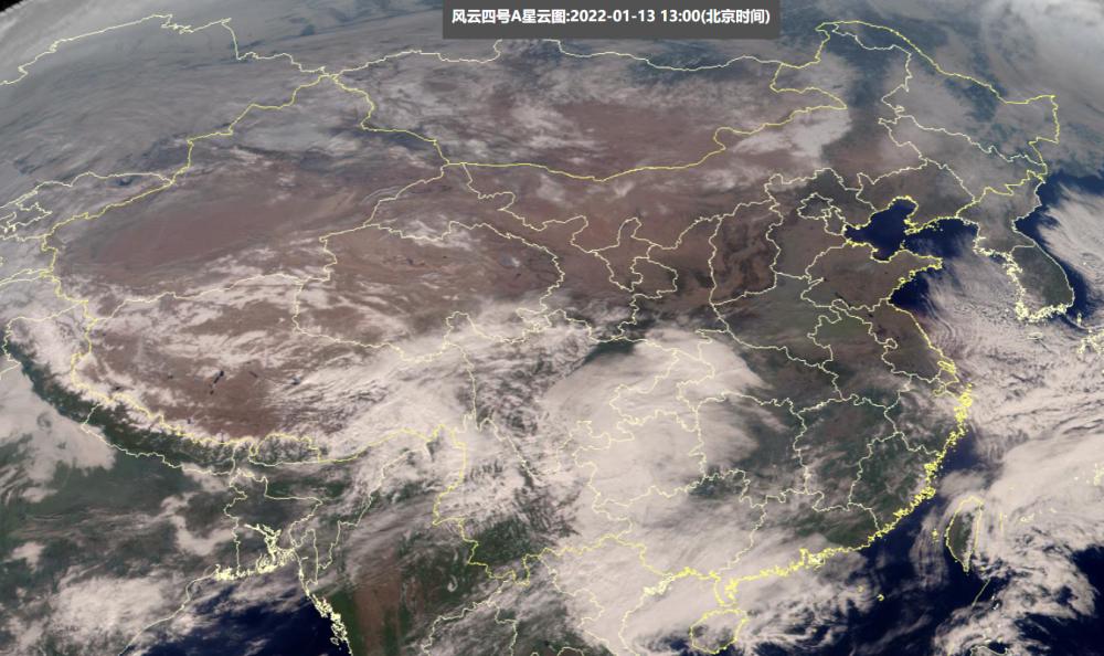
However, on the central and western fronts, the weather has begun to change significantly - as can be seen on satellite cloud maps, today in the southern part of the Qinghai-Tibet Plateau, the southwest region and the western part of South China, a large range of rainy clouds have appeared, compared with January 12, January 13, Tibet, Yunnan and other places have been significantly expanded. The Central Meteorological Observatory pointed out that on January 12 (yesterday), there was light snow or sleet in southeastern Tibet, northwestern Yunnan, and northern Sichuan Plateau, moderate to heavy snow in Aba Prefecture, Sichuan, and moderate to heavy rain in the southern Nyingchi region of Tibet and the Nu River in Yunnan.

This is exactly the product of the fluctuation of the south branch in the west wind of the south branch, and the flow of water vapor in the Indian Ocean to Tibet, Yunnan, Sichuan and other places. Many of today's large-scale clouds are actually "snow clouds". As the fluctuations of the south branch move further eastward, the water vapor in the area east of the Yunnan-Guizhou Plateau in China will also be further enhanced, the scope of rain and snow will be further expanded, of course, the places where snow will fall will be further increased.
Due to the current preparation of cold air going south, the warm and humid water vapor re-enhanced in the south will compete head-on with the cold air, and from the prediction of the supercomputer, after the snow drifts in the high-altitude areas of Sichuan, Yunnan, Tibet, there are also obvious signs of snow in Hubei, Hunan and Chongqing in China.
According to the forecast of the Central Meteorological Observatory, from January 13 to January 14, in addition to snowfall in many places in Sichuan, Yunnan, Tibet, the mountains of southern Shaanxi, northern and southeastern Chongqing, northeastern Guizhou, northwestern Hunan and central and western Hubei will have significant snowfall, especially Hubei, according to the forecast of the Central Meteorological Observatory, moderate to heavy snow may occur in southwest Hubei.
Since the cold air is not very strong, the rain and snow dividing line is relatively north, and the Central Meteorological Observatory believes that sleet will occur in more places in the south. The snow in the south this winter is a little strange. As early as the beginning of November, there were brief ice grains in Jianghuai and other places. The cold wave in December pressed the snow line to Nanling, but the Nanjing line in Hefei, which was the most snow-prone in previous years, has only seen a little "scalp snow", and only Guizhou Hunan has a lot of snow in the "final cold wave" in late December. Judging from the current forecast of the Central Meteorological Observatory, this rain and snow will be further advanced to the east after sweeping the central and western regions, and there are also opportunities for snow in central and eastern Hubei, south-central Anhui, Jiangxi and parts of Zhejiang, but the magnitude is still not very large, mainly small to medium snow or sleet. Among them, the Anhui line in Hubei May be the first serious snow this winter, of course, in the rain and snow, the southerners' least favorite wet and cold weather in winter will be aggravated.