At 17:00 on the afternoon of February 4, Beijing time, when the sunlight gradually tilted westward and many places in the central and eastern parts of the mainland began to gradually darken on the Cloud Map of the Fengyun No. 4 Visible Light Satellite, a large area of thick was shrouded on the Qinghai-Tibet Plateau in the western part of the mainland, which was the fierce blizzard in Tibet and other places on the mainland.
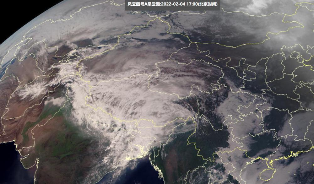
It can be said that this is a huge snow cloud - nielam in southern Tibet, which is located under the snow cloud, has snowfall since February 3, and has been experiencing violent snow today. Monitoring data show that as of 21:00 on February 4, the cumulative snowfall of the 24 hours at Nielamu Station has reached 65.9 mm, which is twice the standard of extraordinarily heavy snow (30 mm), and this snowfall is calculated by the amount of snow into water, and the snow depth recorded by Nielamu Station has been rapidly raised to 77 cm.

The main reason for the appearance of this giant snow cloud and the violent snowfall that brought to many parts of the mainland Tibet was the violent fluctuations in the westerly winds of the South Branch - during the day today, the West Winds of the South Branch twisted violently to form a strong and deep South Branch Trough, which eventually rolled up a huge amount of Water Vapor in the Indian Ocean and crashed headlong into the towering Himalayas. The mountain-turning air currents blew a Category 14 hurricane of 42.8 m/s at Everest Base Camp, and in Nielamu, Tibet, which is located on a windward slope, it turned into a blizzard.
Of course, this deep south trough system will be further spread in the south branch of the west wind in the middle of the East, after the mainland Tibet has become the focus of water vapor transportation, the fierce snowstorm in front of the Himalayas is actually a preview of the next round of rain and snow weather in the central and eastern regions - with the large amount of water vapor brought by the south trough into the central and eastern regions, starting from February 5, the southern rain and snow will make a comeback.
For example, from February 6 to February 7, the forecast of the Central Meteorological Observatory believes that the scope of rain and snow in the southern part of the mainland will be expanded again, from the southwest region to Jianghan, Jianghuai, Jiangnan, and South China will once again be fully immersed in rainy and snowy weather, especially in the middle and lower reaches of the Yangtze River, there may be a wide range of snowfall or sleet/rain to snow, according to the existing forecast, Anhui Zhejiang Hubei Hunan four provinces may also appear to be heavy to blizzard. Overall, after the temporary weakening of rain and snow in these two days, the next strong rain and snow and wet and cold weather will once again sweep through many parts of the central and eastern regions.