◎ Zhao Junqi Yi Ling Dong Changzhe Chen Baojuan Science and Technology Daily reporter Fu Yifei Cao Xiuying
At 2:16 a.m. on April 16, the Long March 4C carrier rocket was launched at the Taiyuan Satellite Launch Center, sending the world's first satellite with carbon dioxide laser detection capabilities, the Atmospheric Environment Monitoring Satellite, into a predetermined orbit, and the launch mission was a complete success. The Star Arrow was developed by the Eighth Academy of China Aerospace Science and Technology Group Co., Ltd.
Photo: Zheng escapes
Atmospheric environment monitoring satellite is a scientific research satellite in the "National Civil Space Infrastructure Medium- and Long-term Development Plan (2015-2025)", running a 705-kilometer sun-synchronous orbit, the whole satellite launch weight of about 2.6 tons, loaded with atmospheric detection lidar, high-precision polarization scanner, multi-angle polarization imager, ultraviolet hyperspectral atmospheric composition detector and wide-format imaging spectrometer and other five remote sensing instruments, is a set of CO2 laser active detection, fine particle stereoscopic detection, Multi-element integrated monitoring satellite for gaseous pollutant detection and surface environment detection.
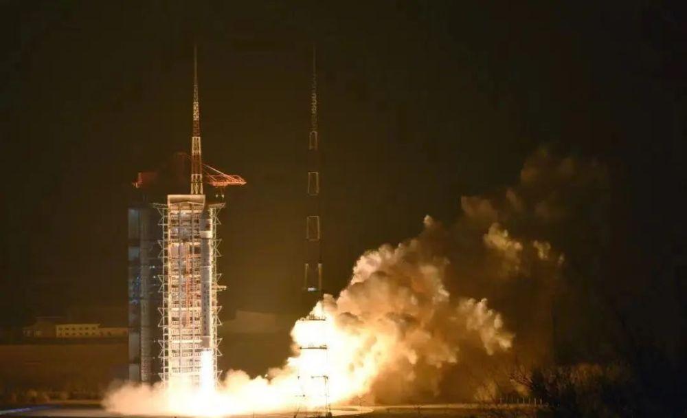
The Long March 4 C carrier rocket was launched. Photo by Wu Jingbo
The successful launch and on-orbit application of the atmospheric environment monitoring satellite marks that the mainland has reached the international leading level in the field of atmospheric remote sensing, and the application of the satellite in orbit will achieve a leapfrog improvement in the capacity of quantitative remote sensing services in many fields such as ecological environment, meteorology and agriculture, providing strong support for the mainland to achieve the goal of pollution reduction and carbon reduction synergy and build a beautiful China.
For the first time, it is equipped with lidar for atmospheric detection
The Atmospheric Environment Monitoring Satellite has created three world firsts in terms of CO2 detection means and accuracy, active and passive detection of fine particulate matter and polarization crossfire detection system.
Carbon dioxide detection, lidar works wonders. The atmospheric environment monitoring satellite realizes the first active detection payload of atmospheric detection lidar in the world, realizes the high precision, all-weather and global detection of active laser CO2, and greatly improves the detection accuracy to better than 1ppm, reaching the highest international level, providing the most accurate remote sensing data support for the mainland to achieve the goal of "carbon peaking and carbon neutrality". At the same time, atmospheric detection lidar through the layered "CT" scanning of the atmosphere, for the first time in China to achieve the global aerosol optical thickness, shape and size and other vertical distribution information acquisition.
PM2.5 monitoring, comprehensive means to a new high. Atmospheric environment monitoring satellite for the first time in the world adopts the active and passive combination, multi-means integrated detection system, through the loading of different types, different principles of the load, the active transmission of laser received echo signal and passive reception of sunlight reflection signal combined, comprehensive inversion of a variety of remote sensing data, to achieve high-precision monitoring of the concentration of fine particulate matter (PM2.5, etc.) near the ground, to provide scientific data support for the precise prevention and control of air pollution.

Courtesy of the Eighth Academy of China Aerospace Science and Technology Corporation
Polarization crossfire, information fusion efficiency is high. Atmospheric environment monitoring satellite International for the first time using fusion inversion-level polarization crossfire detection technology, to obtain aerosol optical thickness, particle scale and other parameters, through the space, radiation and polarization dimensions of information fusion, greatly improve the detection accuracy of fine particulate matter, to reach the international advanced level. In addition, the ultraviolet hyperspectral atmospheric composition detector and wide-format imaging spectrometer will also greatly improve the monitoring capabilities of gaseous pollutants and the surface environment, and double the spatial resolution of ultraviolet hyperspectral atmospheric observation and wide-range multispectral observation.
For the first time, the self-calibration technology of the optical axis of the laser without control point is innovatively applied
Atmospheric environment monitoring satellites can fly around the earth 14 times a day, and lidar works day and night all day, which can be described as a conscientious "labor model". In addition to dedication, it is also a complete "obsessive-compulsive disorder", always do not forget to correct their posture to ensure high pointing accuracy, for this reason, for the first time in China, the innovative application of uncontrolled point laser optical axis self-calibration technology.
Courtesy of the Eighth Academy of China Aerospace Science and Technology Corporation
The premise of the smooth performance of this "magic skill" is to have a "ruler" that can provide absolute attitude information in real time, that is, the "eyes" of the "driver" - the star sensor. After the beam of the light source emitted by the lidar itself is reflected by the prism on the star sensor bracket, the on-orbit calibration system of the lidar and the star sensor is established, so that the lidar can use the "wise eyes" of the star sensor to determine in real time where it is.
According to Sun Shang, deputy director of the satellite attitude-orbit control subsystem of the Control Institute of the Eighth Academy of China Aerospace Science and Technology Corporation, in order to provide high-precision on-orbit three-axis inertial measurement accuracy, the attitude-orbit control subsystem adopts a high-precision multi-headed star sensor. "It's like using 'three eyes' to locate at the same time, using a 'brain' fusion to process higher precision attitude measurement data."
It is reported that during the "Fourteenth Five-Year Plan" period, the mainland will also launch high-precision greenhouse gas comprehensive detection satellites, and network observation with atmospheric environment monitoring satellites to further enhance the mainland's space-based carbon monitoring capabilities and levels, and contribute to the construction of ecological civilization on the mainland and the realization of the "double carbon" goal.
Source: Science and Technology Daily
Editor: Zhang Qiqi
Review: Yue Liang
Final Judge: He Yi