The Altai Mountains (Russian: Алтай; English: Altai Mountains) run in a northwest-southeast direction, diagonally across the borders of China, Kazakhstan, Russia and Mongolia, stretching for more than 2,000 kilometers; the southern slopes of the middle section of the Altai Mountains in China are more than 500 kilometers long and 1,000-3,000 meters above sea level. The main ridge is above 3,000 meters high, and the highest peak in the north is Friendship Peak, with an altitude of 4,374 meters.
This is the geographical concept that people give today in the Altai Mountains. Friendship Peak is located in China, in Burjin County, Altay Region in the northern part of the Xinjiang Uygur Autonomous Region, close to the junction of China, Mongolia, Russia and Kazakhstan. If you take this as the starting point, the north and south of the Altai Mountains can be roughly divided into two regions, the south belongs to the Altai region of China, and the north belongs to the Burgen province of Mongolia.
From these two regions to the east and west, one will find an interesting geographical and historical phenomenon, that is, the Altai Mountains became the dividing line between the white and yellow peoples in ancient China, so that there was no white people in the east; thus to the west, the composition of the human race had a white component on the basis of the yellow race.

First, the cultural landscape separated by the mountains
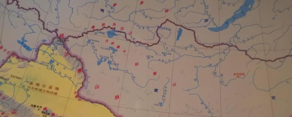
Burgen Province was historically part of the Desert North region of China, bordering present-day Russia to the north, and the Tangnu Ula Mountains, Khankhhuhe Mountains, and hangai Mountains (Yanran Mountains in ancient Chinese texts) and Altai Mountains formed a "corridor" (or narrow basin) in this area, bringing together the people-to-people exchanges in this area in the Tangnu Uriang Sea.
The Tangnu Uliang Sea is the old name of Tuva, historically belonged to Chinese territory, occupied by Tsarist Russia in 1914, and now usually refers only to the "Tuva Republic" of the Russian Federation, with an area of 168,604 square kilometers, part of the Siberian Federal District, with its capital as Kyzyl. This area has been Chinese as early as the Han Dynasty. During the Tang Dynasty, it was the capital of The Prefecture, which was under the jurisdiction of the Protectorate of Anbei and was officially incorporated into the territory of China. During the Song and Jin dynasties, it belonged to the Western Liao regime and was called Qianqian Prefecture. In the Yuan Dynasty, it belonged to Lingbei Province, called Yilan Prefecture. In the Ming Dynasty, it belonged to the Mongolian Wallachian Department, and in the Qing Dynasty, it was called tangnu Wulianghai, which was under the jurisdiction of Zasaktu Khan of Outer Mongolia. The Treaty of Bryansky of 1727 stipulated that China and Russia were bounded by the Sayan Ridge and were under the jurisdiction of General UriaSutai.
The Tangnu Uliang Sea of the Qing Dynasty is one of the three parts of the Uliang Sea, located in the northwest of Outer Mongolia, north to the Sayan Ridge, south to the Tangnu Mountains, west to the southeast of Barnaul in Russia, east to the east of Kusugurpo in Outer Mongolia, is a narrow basin surrounded by mountains, the Tangnu Uliang Sea during the Qing Dynasty contains not only the "Tuva Republic" of the Russian Federation, but also the northeast of the "Altai Republic" of today Russia, the southeast of the "Altai Territory", the southern part of the "Kemerovo Oblast", the south of the "Khakas Republic" and the "Mongolian Empire". Kusugur province "mostly, with a total area of about 380,000-400,000 square kilometers.
This geographical structure allowed the Altai Mountains to start with the Friendship Peak and theoretically become the dividing line between the yellow and white people in ancient China.
It should be noted that today's Xinjiang can not be equated with the ancient western region, from a geographical point of view, the geographical area of the ancient western region is more extensive than today's Xinjiang, in addition to the Tuva region mentioned above, but also includes what we call "Waiyili" today and some places in Central Asia. In such an area, the Altai Mountains basically played the concept of ancient Chinese racial dividing line. That is, from the present-day Burgen province to the west across the Altai Mountains, there were Caucasians in the western region of ancient China.
It should also be noted that in the Han and Tang Dynasties of China, there was no concept of Today's Russia and Kazakhstan. Today, the Altai Mountains enter the territory of Russia and Kazakhstan and are called the Rudnean Altai Mountains, and the southern part is called the Gobi Altai Mountains in Mongolia. Historically, ethnic exchanges north, east, south, and west of this mountain were mainly through the aforementioned Tangnu Uliang Sea, which is the northern region of the "corridor" mentioned above. This is a human geography separated by mountains.
The important thing, again: in ancient Chinese texts, there are no Caucasians on the line from the Friendship Peak to the Gobi Altai Mountains to the east. This caucasian-free area roughly consisted of a line from friendship peaks northward to the Ludne Altai Mountains to the 50th parallel north, then bounded by the 50th parallel north, all the way south of the 50th parallel in today's northeastern China. That is to say, from the Altai Mountains to the west into the western region of ancient China, you can see the Caucasians; to the north, only across the 50 degrees north latitude line, you may be able to see the Caucasians.
2. Ethnic fusion north of the 50th parallel north
After the dividing line of the Altai Mountains, I pulled out the 50 degrees north latitude line and used the expression "Maybe we can meet the Caucasians", because crossing the 50th parallel line is the concept of "extreme north" in the ancient Chinese geographical concept, where there is a lot of history that we are not very clear about, but there seems to be a White people. In ancient Chinese history, the source of the Caucasians there is associated with the Origin of the Caucasians there.
The Qrqz (Turkic: Kirγiz) were a small tribe in the northwest of the Tang Dynasty. It is located three thousand miles northwest of Huiyi, about the upper reaches of the present-day Yenisei River. Han made Mane Kun, also known as Jie Kun, or Jian Kun; from the Southern and Northern Dynasties to the Sui Dynasty as bone protection, or bone, Qi bone, and bone; in the middle of the 8th century, the Orkhon Turkic stele was Qrqz, and the common Chinese translation name of the Tang Dynasty was 黠戛s. They were originally a branch of the ancient Asiatic people, the yellow race. However, due to frequent exchanges with surrounding tribes and ethnic groups, he gradually became Caucasian and became red-haired and green-eyed, "everyone grows up, red hair, face analysis, green pupils, and black hair is ominous."
On this point, the historical record is that after the Xiongnu conquered the Tangas, Li Ling was put in charge of the Tang dynasty, and later in the Turkic annexation war, the Tangas took in a large number of White-majority Siding Zeros, and gradually became the majority of Caucasians. Although the image has changed, He is convinced that he is a descendant of Li Ling and has come to Chang'an to meet Emperor Zhongzong of Tang. Emperor Zhongzong of Tang not only recognized them, but also said, "The kingdom of Er is the same as our country, not other than others." ”
So, what kind of ethnic group is the Dingzhi people who affect the appearance of the Tang dynasty? Ding Zero is the name of an ancient ethnic group in northern China. Also known as Ding Ling, Ding Ling, Nail Spirit. Also known as Gao Che, Di Li, Tie Le, Ding Zero (Ding Ling). During the Three Kingdoms period, some of Ding Zero were still nomadic in the south of present-day Lake Baikal, called North Ding Zero; some migrated to the Altai Mountains, south of Wusun and Cheshi, and southwest of Kangju, called Xiding Zero. It is the Sidin Zero who influences the appearance of the Xiding People, and from a geographical point of view, it is clear that the Caucasian composition of the Xiding Zero people comes from what is called Central Asia today and Xinjiang, China. But the Caucasians were mainly in Europe, and the Caucasians were mainly of European descent, and there may have been a possibility that the Caucasians crossed the Ural Mountains, crossed the Ob River, and completed their fusion with the Yæses on the Yenisei River.
The Yenisei River originates in Mongolia and flows north towards the Kara Sea. The Yenisei River is also the boundary between the West Siberian Plain and the Central Siberian Plateau, the plain is in its west and the plateau is in its east, and it is the largest river flowing into the Arctic Ocean among Siberian rivers.
The Ob River originates from the Irtysh River (known as the Stone River of Ye'er during the Yuan Dynasty) in China, and forms the Ob River with the Biya and Kato rivers originating in the Altai Mountains in the southwest of Bisk in Altai Krai, and eventually flows eastward into the Arctic Ocean.
Both the Yenisei and Ob rivers are large rivers in present-day Russia, both belonging to the Arctic Ocean water system, and the main basins are also north of the 50th parallel north. Although it is not known today whether the historical Caucasians descended the river or crossed the Ural Mountains to appear on the plain between the two rivers, it is true that the Caucasians influenced the appearance of the Siding Zero and the Sycas in that era.
If the river can be understood as a continuation of the mountains, the source of the river is also in the Ob River in the Altai Mountains, but it does not play a role in the demarcation of the Yellow and White races in the Altai Mountains, which is why I dragged out the 50 degrees north latitude line. Here, ancient races converged, and crossing the river seemed easier than crossing the mountain. This is also an interesting geographical phenomenon.
The Altai Mountains are a barrier that is difficult to overcome, which also makes the "corridor" mentioned above produce a scenic area in its south that integrates with the same people-to-people exchanges as the Tangnu Wuliang Sea, which is the area between the Altai Mountains and the Gobi Altai Mountains, from which it enters the territory of present-day China, or through the North Tower Mountain to the area of Qitai and Jimsar; or through present-day Ejina through the Hexi Corridor to Dunhuang and Hami. That is to say, the Caucasians in the history of ancient China may also have come from the southern and northern Xinjiang of present-day Xinjiang and reached the present-day Hexi Corridor and the Inner Mongolian Plateau. The Altai Mountains are even more pronounced here as the dividing line between the Caucasians and the Yellows of ancient China.
Third, the Xianbei people also have caucasian components?
From the northwest to the northeast of the motherland, the distance in a straight line is also very long. But what is more interesting is that the Ding Zero people, who have influenced the appearance of the People of the Tang Dynasty, have also affected the appearance of some humble people.
The Xianbei people originated from the remnants of the Eastern Hu who were broken by the Xiongnu and retreated to baoxianbei Mountain, and modern archaeology proves that the Eastern Hu belong to the yellow race and do not have Caucasian characteristics. However, the composition of the Xianbei people is not as simple as the remnants of the Eastern Hu, historically, after the Xiongnu conquered the Eastern Hu, there was a migration to the east, so the Xianbei people and the Xiongnu and the Huns were similar in terms of customs.
Similarly, the Xiongnu conquered the Ding Zero people, and both the Chronicle of the Xiongnu and the Book of Han record that the Xiongnu Were alone in the "Northern Service Ding Zero", and some of the Ding Zero people gradually moved south to live with the Xiongnu, and that wei lu, which was famous in history, was named "Ding Zero King" by the Xiongnu Shan Yu.
Therefore, the Ding Zero people affect the appearance of the Xianbei people. There are two main reasons: one is the eastward migration of the Huns; the other is the rise of the Xianbei people.
Yuwenbu Xianbei is an important branch of the Xianbei, but they did not originate in the northeast, and like other Xianbei tribes, they were mainly Huns. According to the Book of Zhou and emperor Wen, the leader of the Yuwen clan "migrated from the Yin Mountains and first lived in western Liaoning", from which we can see the fact that the Yuwen clan moved to the northeast. Murong Xianbei was also an important branch of the Xianbei, and at the beginning of Wei, Murong Xianbei moved from Saiwai in Shanxi to Liaoxi Commandery due to the Battle of Wei to destroy Yan. The Biography of Murong Xi of the Book of Jin states: "(Murong Hui)'s great-grandfather Mo Hubao, Wei Chu led his troops into Liaoxi, from Emperor Xuan (Sima Yi) to the Gongsun clan, worshiped the righteous king, and founded the state north of The City of Thorns. It also explains the fact that Xianbei has moved to the northeast.
The Later Han Shu Wuhuan Xianbei Biography says: "In the middle of The Emperor Yongyuan, the great general Dou Xian sent the right lieutenant Geng Kui to defeat the Xiongnu, and Beidan Yu fled, so Xianbei moved to his place. There are still more than 100,000 remnants of the Xiongnu, all of whom call themselves Xianbei, and Xianbei has gradually flourished. ”
These historical records all show that whether it is the migration of Xianbei or the strength of Xianbei, there are many blood of the Huns, or the Northern Xiongnu, and the Northern Xiongnu are mixed with the Ding Zero. Therefore, in the ancient books, some of the Xianbei people were blonde and yellow-bearded, and they had some of the physiognomy characteristics of caucasians.
However, what I would like to say is that this influence was very limited, quickly disappeared into the long river of history, and did not affect the geographical concept of the ancient Chinese Altai Mountains as the dividing line between yellow and white people. The ethnic and ethnic integration scenery at both ends of the "corridor" composed of Tangnu Ula Mountain, Khan Huhe Mountain, and Hangai Mountain and Altai Mountain needs more people's attention and research.
The pictures in this article are from the network, thanks to the original author!
For more exciting content, come and follow the human geography of the west