The Northeast Asian continent with Northeast China as the main body is a collage formed by the subduction and collision of multiple micro-land masses, which has been deeply superimposed and transformed by the two major tectonic systems of the (ancient) Pacific Ocean and Mongolia-Okhotsk since the Mesozoic Era. Extensive seismic imaging has shown that the Pacific Plate has been massively entrenched in the mantle transition zone below Northeast Asia, forming the world's unique East Asian "Big Mantle Wedge" system. Therefore, the northeast region of the mainland is an ideal area to study the internal processes of the "mantle wedge" system and its effect on the transformation of the overlying plate. Seismic anisotropy describes the dependence of seismic wave velocity on direction, records the kinetic information of the subsurface medium, and is a probe for spying on the deformation of the deep earth's structure and material circulation, which has important indicative significance for the dynamic process of the earth's deep part.
Dr. Yang Fan, Dr. Guo Guangrui, Key Laboratory of Earth and Planetary Physics, Institute of Geology and Geophysics, Chinese Academy of Sciences, Researcher Li Juan, and collaborators Chen Qifu and Associate Researcher Chen Yun, based on high-quality seismic waveform data recorded by NECSaids dense flow array (Figure 1), using SIMW (Simultaneous Inversion of Multiple Waveforms) method to analyze and process SKS seismic phases. Stable and reliable shear wave splitting results across the Northeast Asian continent (Jilin Hunchun-Inner Mongolia Erenhot profile, total length of about 2000 km) were obtained. Combined with the existing S wave reception function and regional tomography velocity model, the spatial variation of anisotropy and the main source depth of this region are systematically discussed, and the first-order characteristics of mantle dynamics across northeast Asian continents are given.
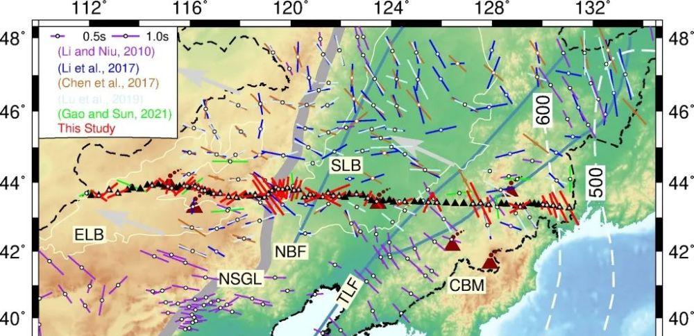
Figure 1 Background of geological structures in Northeast China and the results of XKS shear wave splitting
Analysis of shear wave splitting results showed that the overall characteristics of anisotropy showed obvious zoning bounded by the north-south gravitational gradient zone (NSGL, a first-class feature of the lithosphere of the East Asian continent). West of NSGL, the fast axis is dominated by ENE, with less delay time than in the eastern region, but there are complex splitting parameters around Abaga Volcano. East of NSGL, the fast axis direction is dominated by NNW, roughly parallel to the average of the absolute motion direction (APM) of the plate, but the splitting parameters in the underground of the Songliao Basin are relatively scattered, and there are more stations without splitting results in the Changbai Mountain area, which indicates that the mechanism of seismic anisotropy in this area is not unique, and there is a regional mantle flow. Even more interesting is the presence of a systematic clockwise rotation from NNW to NNE in the fast axis direction within a range of 200 km around NSGL, which may correspond to a drastic change of 60-80 km in the thickness of the lithosphere in this area (Figure 2b).

Fig. 2 (a) Shear wave splitting results obtained using simw method; (b) S wave velocity anomaly plot along the measured line (~43.5°N) of the plateau array; (c) statistical histogram of the fast axis direction and delay time on the east and west sides of the boundary with the north-south gravitational gradient band (118.5°E).
The results show that the lithosphere on the west side of the north-south gravitational gradient belt is generally stable, and the degree of deformation is weak or limited, while the lithographic descaping induced by the subduction plate in the western Pacific Ocean on the east side forms a complex regional mantle flow. A step change in the thickness of the lithosphere (keel) that leads to the turning or rotation of localized mantle flow, a phenomenon in the eastern United States (West et al., 2009; Yang et al., 2017) and li et al., 2020 are also reflected, and this Keel-Deflected mantle flow pattern is clearly proposed for the first time in northeast China (Figure 3). For the detailed characteristics of the mantle flow pattern under the constrained local area (such as Changbaishan Volcano and Abaga Volcano), it is necessary to combine multi-method geophysical data, geochemical observations and three-dimensional geodynamic simulations to verify.
Figure 3 (a) SKS shear wave splitting measurements in the study area and (b) Schematic diagram of keel-Deflected mantle flow patterns below the Northeast Asian continent
The research results were published in the international academic journals GRL (Yang Fan, Guo Guangrui, Li Juan*, Chen Qifu, Chen Yun, Chen Sidan. Panoptic view of mantle flow beneath trans-continental Northeast Asia: Distinct variation detected from ~2,000 km shear wave splitting profile [J] . Geophysical Research Letters, 2022, 49: e2021GL097116. DOI: 10.1029/2021GL097116。 This achievement was funded by the National Natural Science Foundation of China (42074063, 41774065, 41774058), the Strategic Pilot Project (B) of the Chinese Academy of Sciences (XDB18000000) and the Key Deployment Project of the Institute of Geology and Geophysics of the Chinese Academy of Sciences (IGGCAS-201904).
Editor: Chen Feifei
Proofreader: Wan Peng