It has been 10 days since the eruption of The Aha Apayee Volcano in Tongahun. What was the situation after the disaster? How is it different from before the disaster? Take a look at the satellite photos provided by the Satellite News Laboratory of Xinhua News Agency to see the changes brought about by the volcanic eruption in Tonga based on remote sensing images.
Geological changes
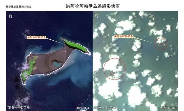
About 65 kilometers north of Tonga's capital, Nuku'alofa, The island of Hong Aha Apay began erupting on the morning of January 14 and erupted again on the afternoon of 15 January. Comparing satellite photos, it can be seen that before the eruption, Hong Aha Apay Island consisted of two small islands and volcanic rocks; on January 16, the volcanic islands that were originally connected together became two small islands, and the location of the original volcanic rocks in the middle became water.
In addition to the impact on Hong Aha Apay Island, a large amount of pumice appeared in the surrounding sea after the eruption, and the length of the band ranged from a few meters to more than 10 kilometers. There are still some pumice stones, but not as dense as when the volcano first erupted.

volcanic ash
Volcanic eruptions cause large amounts of ash, gas and water vapor to enter the sky to form huge clouds, which erupt to a height of 20 kilometers. The Tonga government issued a disaster notice on the 18th, saying that the volcanic eruption caused a tsunami as high as 15 meters. However, compared with the short-term direct damage caused by eruptions and tsunamis, the long-term impact on the environment in the follow-up needs to be continuously observed and assessed. Satellite imagery of Tonga taken during this time shows that the ground in many areas is still covered with volcanic ash.
On 16 January, part of Tonga's surface was earth-grey and covered with volcanic ash.
The team of scientists studying the impact of volcanic ash at Cornell University in the United States issued a statement on the 18th, saying that in addition to the direct damage caused by the volcanic ash layer and the tsunami to the infrastructure, the thick volcanic ash will cause great harm to human health and the environment, and the interaction between seawater and volcanic ash particles has exacerbated these hazards.
The global impact is limited
Based on data analysis, NASA believes that the volcanic eruption will not have much impact on the global climate. If enough volcanic eruptions enter the stratosphere, it has the potential to have a cooling effect on the global climate. However, the eruption of the Tonga volcano only injected about 400,000 tons of sulfur dioxide into the upper atmosphere, while at least 5 million tons of sulfur dioxide generally entered the upper atmosphere to have an impact on the climate.
Satellite imagery shows that on January 21, Tonga's neighbor Fiji Coral Island turned green, saw no obvious volcanic ash, and no pumice rocks were found in the surrounding waters.
Source: Xinhua International Headlines