Saint Martin (Sint Maarten) is located east of the Virgin Islands, northeast of the Atlantic Ocean and southwest of the Caribbean Sea. With an area of 86 square kilometers and a population of about 80,000, it is about the same size as Changxing Island (the island where China built aircraft carriers) at the mouth of the Yangtze River. Although the island is not large and there are not many people, it belongs to France and the Netherlands.
The following is what I wrote after looking at the beautiful pictures for a while, and everyone can take a look at it ~ ~~
Let's talk about the current situation on the island of Saint-Martin, the northern part of the island is French Saint-Martin, which was separated from the French overseas province of Guadeloupe in 2007 and is a direct overseas territory of France, with an area of 52 square kilometers and a population of nearly 40,000. Sint Maarten in the south was originally part of the Netherlands Antilles, and after the separation in 2010, like Aruba and Curaçao, it became the smallest overseas autonomous state in the Netherlands, with an area of only 34 square kilometers and a population of almost 40,000.
Among the many islands in the world, it is not uncommon for an island to belong to two or even three countries, such as Timor Island, Kalimantan Island, New Guinea Island, etc. I mentioned earlier, but usually these islands are relatively large and have a large population, but the reason is more interesting that an island like St. Martin, which is at best an ordinary township in China, belongs to two countries. To put it bluntly, it is actually the result of a long game of Western colonists in the Caribbean.
Historically, the first inhabitants of St. Maarten were Indians known as Arawak. For Westerners, the island was first discovered by Columbus on the day of St. Martin's Day (November 11) in 1493 (the sixth year of Akihiro's reign), so Columbus named it "Saint Martin". Since Spain could easily buy cheap salt from Portugal, the salt-marshed island of Saint-Martin was declared territory and not developed and colonized. More than thirty years later, the two European French and Dutch colonies of the Americas established strongholds on the island from the north and south, respectively, and the Dutch West India Company also began a large-scale development of the island's salt marshes. Later, in 1633 (the sixth year of Ming Chongzhen), the Spaniards recaptured the island for a time, but in 1648 (the fifth year of Qing Shunzhi) they withdrew. On March 23, the year the Spaniards withdrew, France and the Netherlands signed a "Treaty of Concordia" to jointly occupy and divide the island.
Even after the treaty was signed, The island of Saint Maarten changed hands 16 times and was even occupied by the British for a time, until 1817 (the twenty-second year of Qing Jiaqing), when the boundary between the two countries was finalized and maintained to this day.
From the 17th century to the 19th century, the island's economy was dominated by the salt industry and cotton, tobacco and sugar cane plantations, because the plantations required a large amount of labor, so the plantation owners began to use black slaves in large quantities, until the mid-19th century, France and the Netherlands abolished slavery on the island. It is precisely because of this that the current demographic structure of Saint-Martin is still dominated by blacks and mixed races.
Now St. Martin, mainly with duty-free islands and white sand beaches to develop tourism, a large number of hotels and luxury villas and resorts are scattered all over the island, while the traditional industries are preserved as well as fishing and winemaking, due to the prosperity of tourism, the economic level of the island is quite high.
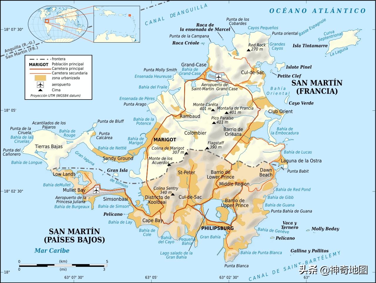
Map of the st. Martin's political district

Topographic map
Traffic map
Satellite view
Tourist map
Old map
In the Caribbean, San Martin is a little bit
Finally, let's talk about the famous Princess Juliana International Airport, which is located on the west side of the Dutch part. The airport was not built to develop tourism. In 1943, German U-boats threatened the Caribbean, and in order to deal with these mysterious submarines, the United States built an airfield on the island for anti-submarine aircraft, which was officially opened in 1943. After the war, it was converted into a civil aviation airport, and at the end of the runway is a beach with many tourists, the shock of the plane skimming overhead and the huge shock wave of the large jet engine, so that every visitor here has a special experience. And the bikini and the large passenger plane in the same frame of the photo, but also for aviation enthusiasts or beauty lovers to talk about, at least, when I look at it, it will leave a ha lazi ~~