Ming Inspector 丨 Zheng Shujing
At a glance
Is Hong Aha Apay Island gone? Little remains, but there are still components of the original island left on the surface of the sea.
Was it "blown up"? Satellite images show that before the eruption of Hong Aha Apay volcano on January 15, the central ground of the volcanic island had collapsed and disappeared below sea level.
UNSAT confirmed that the cone crater of the Hong Aha Apay Volcano collapsed. The study found that the collapse of the crater may exacerbate the intensity and duration of the eruption.
Event background
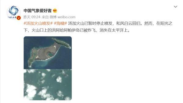
On January 15, local time, the south Pacific island nation of Tonga (Hunga Tonga-Hunga Ha'apai) submarine volcano erupted violently, a large amount of volcanic ash, gas and water vapor formed a huge cloud above the archipelago, communication was interrupted, Tonga almost all lost contact.
On January 18, as volcanic ash spread westward over Hong Aha Apay Island, people were finally able to glimpse the state of the submarine volcanoes of Hong Aha Apay Island through the eyes of the satellite. After the high-definition comparison map before and after the eruption flowed out, Weibo messages showed that after the eruption of the Tonga volcano, "the island of Hong Aha Apai on the crater has been blown up and disappeared into the Pacific Ocean." ”
What kind of island is this Hong Aha Apay Island that is rumored to have been "blown up"? Is it really gone?
Mingcha
Is the island gone?
Using Google Images to reverse search, it was found that on January 18, the United Nations Satellite Center, Xinhua News Agency and the Us Broadcasting Corporation all released satellite comparisons similar to the online images.

Satellite images of Hong Aha Apai Island provided by unsattended satellite centres were taken on December 11, 2021, January 6, 2022 and January 18, 2022.
Synthetic Aperture Radar (SAR) satellite images released by the Xinhua Satellite Laboratory clearly show that on January 16, the day after the eruption, there were few remaining parts of Hong Aha Apay Island that remained on the surface of the sea.
Synthetic Aperture Radar (SAR) satellite image of Aha Apai Island in Tongahun, taken by sentinel 1 satellite on Jan. 16. The black part of the picture is the sea surface, and the white part is the island.
ABC cites satellite image data from MAXER Technology, a U.S. technology service provider, that by January 18, most of Hong Aha Apay Island was no longer visible in the Pacific Ocean, but the two brown developers in the lower left and upper right of the image seemed to suggest that an island had existed and had not yet completely disappeared.
A comparison satellite image provided by MAXER Technology, above Hong Aha Apai Island in December 2021, and below, taken on January 18, 2022.
Where did the missing parts of the island go?
Satellite images released by Planet Labs, cited by Reuters and the New York Post, reveal a surprising fact: The disappearance of Hong Aha Apay Island did not begin after the January 15 eruption, but before it.
Satellite images show that at 3:25 p.m. local time on January 15, before the eruption of Hong Aha Apay Volcano, about one-third of the central part of the island, including the crater, had "collapsed" and disappeared from the sea.
At 3:25 p.m. on January 15, 2022, the eruption has not yet occurred, and the ground in the center of the island has "collapsed".
According to National Geographic magazine, "collapse events" often occur when rocks on volcanoes suddenly fall into the sea in large quantities, which is related to the unstable structure of the volcano itself and its easy to erupt. According to National Geographic, volcanic activity in the South Pacific, including the island of Hon Aha Apay, follows a similar logic: the Pacific Plate is constantly subducting towards the Australian tectonic plate, and when it descends to the mantle layer, it encounters scalding rocks. The high temperatures bake the moisture out of the subduction plates, the water vapor rises to the upper mantle, exacerbates the melting of the rocks, and the gas-mixed and viscous magma is created, preparing the premise for the eruption of the volcano.
From the very beginning of the formation of Hong Aha Apay Island, NASA researcher Dan Slayback has paid much attention to the island. As early as Jan. 3, Sliebak had observed via satellite imagery that with the early eruptions, the 120-meter-high cone crater on Hong Aha Apai Island had been completely filled with "new material" and the island had increased in size, According to Reuters.
Slybock did not confirm whether the "new material" shown in the satellite images was rock that had fallen from the volcano. It is also not clear whether the cone crater, which was filled on January 3, has already laid the groundwork for the "collapse" of January 15. However, an article by NASA scientists such as Alberto Roman in the April 2021 issue of nature found that the collapse of the crater could exacerbate the intensity and duration of the eruption — "a large amount of rock close to the crater slides into the volcano, interacting with the uneven walls as it slides, stimulating more magma production."
Where did Hong Aha Apay Volcanic Island come from?
Back in November 2015, Xinhua's data map shows that Hunga Tonga-Hunga Ha'apai is still floating above 100 meters above sea level. The black dense structure of basalt on the surface of the island is constantly telling visitors that this is an island formed by volcanic eruptions and is not habitable.
Hong Aha Apai Island in Tonga, taken on November 4, 2015 (Xinhua news agency file photo).
In Tongan, the word Hunga means "volcano". Taxonomically speaking, Hon Aha Apay Island is a volcanic island. Daniel Zhang, associate professor of the School of Resources and Environment of Southwest University, introduced in the "Science Popularization China" series that due to plate movement, the lava flow overflowing from the extinction boundary and growth boundary of the collision of various plates on the seabed will gradually increase upwards to form a submarine volcano. Submarine volcanoes continue to grow upwards during eruptions, and they will emerge from the sea and form volcanic islands.
Volcanic islands that grow out of the ocean are surrounded by seawater and are susceptible to sea erosion. For hundreds of years, Hong Aha Apay Volcano has been lurking on the seabed for a long time, sometimes floating out of the sea to form islands, and will soon be eroded by the sea and return to its original shape. It wasn't until late 2014 and early 2015 that an unexpected eruption pushed The Hong Aha Apai Volcano out of the ocean.
Footage captured by the Landsat 8 satellite shows two small islands in the South Pacific Ocean, about 65 kilometers north of Tonga's capital, Nuku'alofa, on December 2, 2013. On the left is Hunga Ha'apai, on the right is Hunga Tonga, and the two islands are separated by the waters of the South Pacific. But by April 28, 2015, four months after the eruption of Hon Aha Apay, an elliptical land had emerged between the two small islands, and the two islands were magically connected to form the new Hong Aha Apay Volcanic Island.
Landsat 8 satellite captures footage of December 2, 2013, showing two small islands that are not connected, with Hunga Ha'apai on the left and Hunga Tonga on the right.
On April 28, 2015, an oval-shaped piece of land had emerged between the two small islands, forming the entire Hong Aha Apay Volcanic Island.
According to an article published jan. 12 by planet labs, the island's size rapidly decreased in the first six months after its formation, so NASA scientists initially judged that Hong Aha Apay Island would also be swallowed up by the sea as usual. But for 7 years, the island has not disappeared, but has expanded day by day.
On December 25, 2021, Taniela Kula, Tonga's chief geographer, observed that about 300 to 600 meters of land had been added to the eastern side of Hong Aha Apay Volcanic Island, making the entire island appear wider, according to the New Zealand Herald. Kura believes that the expansion of land area is related to the accumulation of fragmentary debris left by the eruption of The Hon Aha Apay Volcano that began on the 19th of that month.
The eruption of Hong Aha Apai Volcano at the end of 2021 did not arouse people's high alarm, and it seems that this is nothing more than a very ordinary volcanic activity. After all, the hong aha apay volcano is well known to the world, according to new Zealand meteorologist Peter Lechner, since the 20th century, there have been at least five recorded eruptions here, in 1912, 1937, 1988, 2009 and 2014-2015.
It wasn't until January 15, with a loud roar, that the world realized that the eruption of The Hon Aha Apay Volcano was extraordinary, with the mushroom cloud peaks formed by the eruption reaching a diameter of 400-500 km and a height of 19-30 km. Hong Aha Apay Island, which existed for seven years and was born as a result of a volcanic eruption, eventually died out due to a new round of volcanic eruptions.
Is the term "blowing up" reliable?
In an interview with NPR, Slibaker mentioned that the January 15 eruption had completely destroyed Hong Aha Apay Island. The eruption was so intense that it shattered the hard rocks of the older islands around Hong Aha Apay Island into pieces.
In general, there are three main types of eruptions during volcanic eruptions – gas, magma and solid eruptions (volcanic clastic material). According to National Geographic, when magma is mixed with water bodies on the earth's surface, the water in the surface layer will heat up and vaporize violently, causing the magma to burst and decompose into thousands of small particles. These tiny particles collide with each other, sometimes with ice crystals in the atmosphere, and produce an electric charge. When positive and negative charges meet, they can even produce lightning.
James Garvin, chief scientist at NASA's Goddard Space Center, estimated that the power of the Hong Aha Apay eruption was comparable to that of tens of millions of tons of TNT explosives, slightly equal to 500 times the power of the atomic bomb dropped by the United States on Hiroshima at the end of World War II.
Such a powerful outbreak has led to endless claims on the Internet about the "blowing up" of Hong Aha Apay Mountain. Although it may be a joke from netizens, as far as the matter is concerned, Hong Aha Apai Island, which is part of the entire undersea active volcano, strictly speaking, there is no controversy about whether it will be "blown up".
This is because the Hong Aha Apay Island that we can observe on the sea is actually only a very small part of the entire Hong Aha Apay Volcanic Crater, and the huge mountain mass is buried below the ocean surface. The above-mentioned satellite image comparison chart shows that the long-term crustal movement superimposes the influence of atmosphere and ocean currents, and the morphology of Hong Aha Apai Island has been changing in recent years. Eruptions, island formations, and extinctions are the constant themes of the cycle of many submarine volcanoes, including Hong Aha Apay.
Modeling map of the Hon Aha Apay Volcano, showing the exposed Hong Aha Apay Volcanic Island is only a very small part of the entire crater.
At present, in the part of Hong Aha Apai Island that disappeared after the eruption, CCTV News reported that "the crater and most of the island have sunk below the sea surface." The current status of Hong Aha Apay Island by the United Nations Satellite Centre is that the cone crater collapsed after the eruption of The Hon Aha Apay Volcano on January 15, 2022.
According to available information, the expression "Hong Aha Apay Island was blown up" is not very accurate, at least satellite images show that the central ground of the Hong Aha Apay Volcano collapsed and disappeared below sea level before the eruption of the Hong Aha Apay Volcano on 15 January.
As of now, according to the Tonga government, the january 15 eruption has caused at least three deaths and many missing, and the United Nations and the relief operations of neighboring countries in Tonga are being urgently deployed.
Column Editor-in-Chief: Qin Hong Text Editor: Song Hui Title Image Source: Xinhua News Agency Photo Editor: Xiang Jianying
Source: Author: The Paper