About 65 kilometers north of Tonga's capital, Nuku'alofa, The island of Hong Aha Apay began erupting on the morning of January 14 and erupted again on the afternoon of 15 January. Volcanic eruptions cause large amounts of ash, gas and water vapor to enter the sky to form huge clouds, which erupt to a height of 20 kilometers.
Video loading...
↑ Click to watch the video
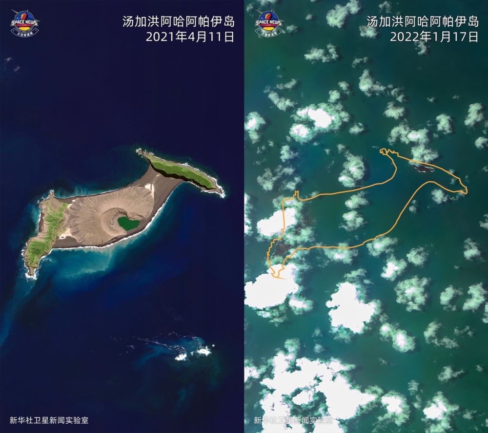
↑This imposition photo shows: Satellite image of Aha Apai Island in Tongahun taken by worldview02 satellite on April 11, 2021 (left) and satellite image of the island after volcanic eruption taken by The Gaofen I satellite on January 17, 2022, with the orange curve being the original outline of the island marked by geographical coordinates.

↑This is a satellite image of Tongahun Aha Apai Island taken by the Worldview02 satellite on April 11, 2021.
↑This is a satellite image taken by the Gaofen I satellite after the eruption of the Aha Apai Island volcano in Tongahun on January 17.
↑This is a satellite image taken by the Gaofen I satellite on January 17 after the eruption of the Aha Apai Island volcano in Tongahun, and the orange curve is the original outline of the island marked according to geographical coordinates.
↑This is a synthetic aperture radar (SAR) satellite image of Aha Apai Island in Tongahun taken by sentinel 1 satellite on January 4. The black part of the picture is the sea surface, and the white part is the island.
↑This is a synthetic aperture radar (SAR) satellite image taken by Sentinel 1 satellite after the eruption of Aha Apai Island in Tongahun on January 16. The black part of the picture is the sea surface, and the white part is the island.
↑This imposition photo shows: Synthetic Aperture Radar (SAR) satellite image of Aha Apay Island in Tongahun taken by Sentinel 1 satellite on January 4 (left) and Synthetic Aperture Radar (SAR) satellite image of the island after volcanic eruption taken by Sentinel 1 satellite on January 16. The black part of the picture is the sea surface, and the white part is the island.
Xinhua News Agency (Courtesy of Xinhua Satellite News Laboratory)
Editors: Wu Jingdan, Pan Siwei, Du Juanjuan, Sun Weitong
Video: Qi Xiaoyi
Produced by the Photography Department of Xinhua News Agency
Xinhua News Agency's international communication integration platform