The eruption of submarine volcanoes in Tonga, an island country in the South Pacific (601099), has affected climate change throughout the Pacific region and even globally, which cannot help but arouse concern and thinking: What is Tonga Volcanic Island? Si Passenger uses 7 years of satellite data to show the transformation of the island where the volcano erupted in Tonga, trying to explore the answer with a new perspective.
Tonga is an island nation located in the western South Pacific Ocean, with frequent volcanic eruptions that continue to shape the size and shape of the island. In April 2019, the Gaofen-1 satellite recorded the area of the island where the eruption occurred.
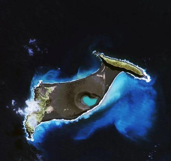
Satellite image of a volcano in Tonga, January 17, 2022. Source: Gaofen No. 1 02 (Courtesy of China Resources Satellite Application Center)
The eruption of submarine volcanoes in the South Pacific island nation of Tonga has affected the entire Pacific region and even global climate change, which can not help but arouse concern and thinking: What is Tonga Volcanic Island? Si Passenger uses 7 years of satellite data to show the transformation of the island where the volcano erupted in Tonga, trying to explore the answer with a new perspective.
On January 17, 2022, Gaofen 1 collected images of the island again, and the red area in the map is the location of the original island.

The satellite also captured images of the volcano before the eruptions on January 7, 2022 and January 15, 2022. Satellite imagery from Planet SkySat shows that a puff of smoke rose from the underwater volcano a few days before the underwater eruption (January 7), and two hours before the eruption on January 15, 2022, the middle part of Hong Aha Apay Island was gone.
Satellite imagery from January 7, 2022 and January 15, 2022. Source: Planet Labs
The "Pacific Rim Seismic Belt" forms a horseshoe shape from North Australia through New Zealand, Indonesia, Malaysia, Japan, Kamchatka, Alaska, the western coast of the United States, Central and South America, all the way to the South Pole.
Schematic diagram of the Pacific Rim Seismic Belt.
Tonga is located in this circular area of about 40,000 kilometers, so the volcanoes are frequent. The island where the eruption takes place was also shaped by the eruption before. Before the eruption, its cone protruded out of the water, but hidden beneath the waves was a huge volcano.
Dynamic schematic diagram of the volcanic island of Hong Aha Apay. Source: NOAA
Back in December 2014, the submarine volcano erupted, and after a month-long eruption process, a new island emerged. Satellite imagery taken by Landsat-8 clearly shows that before the eruption (December 2, 2013), the two small islands were separated by the South Pacific Ocean, while four months after the eruption (April 28, 2015), the two small islands had been connected by volcanic material to form a completely connected area.
Satellite imagery bears witness to the changes in the volcanic island of Hong Aha Apay.
The collision of continental plates has led to frequent volcanic eruptions and earthquakes, and Tonga, which is on the "Pacific Fire Circle", has been shaped and evolved, constantly witnessing the rebirth and demise of the island.
(Informational message)