Tibet is a place that countless people want to travel.
Here, it is as if you can reach out and touch the sky.

The warm sun shines on the body, and everything is so comfortable.
Pilgrims from all over the world come here with the most devout hearts.
There are magnificent snow-capped mountains, sapphire-like lakes, peach blossoms in full bloom... There are many more scenery, and only if you come once can you appreciate its beauty.
In addition to the snow-capped mountains, Tibet also has amazing glaciers.
The towering glacier, illuminated by the sun, emits a crystal blue color, which is unforgettable at first sight.
Go inside Tibet and see the enchanting glaciers.
01
Sap Glacier
Due to the deep valley and inconvenient transportation, Sapp Sacred Mountain has always been hidden in the boudoir and little is known.
In 2017, the Sapp Glacier suddenly became famous, attracting more and more travelers to visit, which can be called the "net red" phenomenon in the glacier world.
Standing on the edge of the glacial lake, looking up, the majestic ice waterfall descends from the peak of the mountain, like a river where a row of swords converges, which is breathtaking.
Best time to see: Beautiful all year round
02
Come to the ancient glacier
Laigu Glacier, which is close to Ranwu Lake, is the largest and widest known glacier in Tibet.
Laigu Glacier stands proudly in the clouds, dazzling white and dazzling blue are the main colors here, white is the glacier snow peak, blue is the ice floes rolling on the ground.
Walking into the crystal clear blue glacier, it is as if you have traveled through time and space to another planet.
Best time to see: January to April every year
03
Rongbu Glacier
Located at the foot of Mount Everest at an altitude of 5,300 to 6,300 meters above sea level, Rongbu Glacier consists of two glaciers, West Rongbuk Glacier and Middle Rongbu Glacier.
It is the most fully developed and best-preserved unique valley glacier form in the world and the largest glacier in the Everest Nature Reserve.
The attitude of the glacier is strange, large or small, gathered together, in the blue sky and white clouds, very beautiful and beautiful.
The colorful ice tallinn stands abruptly, the ice cone is shaped like a sword straight into the sky, and it looks like a group of animal forms, among which there are deep ice caves, twisting glaciers, strange and spectacular, in which you are like walking into a crystal palace of crystal holyness.
Best time to see: Can be viewed all year round, you need to enter the Everest Base Camp
04
Qudenima Glacier (58 glaciers)
There are many glaciers deep in the northern slopes of the Himalayas, located in the Qudenima Glacier in Gamba County, Shigatse Region, Tibet, which is also the source of mineral water for the "Tibetan Sacred Water".
Because it is located on the No. 58 boundary monument at the junction of China and India, it is also known as "Glacier No. 58".
However, due to the current lack of popularity, few people know that even navigating with a map will lead to the wrong location.
Standing by the lake, I saw the moraine lake glowing with a slight blue light, the wind blowing, the lake surface rippled; behind the moraine lake, the glacier stood like a huge rock wall.
Best time to see: June-November
05
Tsojah Glacier (40 glaciers)
40 Glacier, also known as Tsogyat Glacier, is located at an altitude of 5300 meters above sea level near the border between Langkazi County and Bhutan in the Shannan region of Tibet.
Named after Monument No. 40, which borders China and Bhutan, it is the most accessible land mountain glacier ever found, allowing for close contact without special equipment.
Walking into the glacier, crystal towers rise from the ground, under the carving of nature's miraculous craftsmanship, the appearance is different, the height is staggered, just like being in the fairyland of the mythical Qionglou Yuyu.
Looking up, the glacier emits a blue light through the sunlight, and the colorful changes will make people marvel infinitely.
Note: It is currently prohibited
06
Plogangj Glacier
Punogangri Glacier is the third largest glacier in the world in addition to the Antarctic and the Arctic, and is known as the third pole in the world. It is also the largest glacier in the latitudes.
The Plogangri Glacier covers an area of 422 square kilometers, radiating from the center of the ice field to the surrounding valleys more than 50 tongue-shaped glaciers, ice tallinns, ice bridges, ice grasses, ice needles, ice mushrooms, ice lakes, ice stalactites, etc. constitute a diverse ice world.
What is even more surprising is that there are many lakes and deserts scattered extremely rarely outside the Progongi Glacier, and the lakes close to the glacier are not frozen, and the deserts close to the water source have no grass.
The harmonious coexistence of glaciers, lakes and deserts is also rare in the world. This adds a mysterious touch to the Progangzhi Glacier.
Note: It is currently closed and is not allowed
07
Rice Pile Glacier
Midui Glacier is the most important ocean-type glacier in Tibet and the lowest glacier in the world, and has been rated by China National Geographic as one of the six most beautiful glaciers in China.
The main peak of The Rice Pile Glacier is 6800m above sea level, the snow line is only 4600m above sea level, and the end is 2400m above sea level, the lower part of the glacier passes through the coniferous and broad-leaved mixed forest belt, and the mountains on both sides are majestic and steep, and the snowy mountains and clouds are intertwined, like a dream.
Here, glaciers, lakes, farmland, villages, forests, etc. come together to create a model of harmony between man and nature.
Best time to see: Available all year round
08
Kojanggangri Glacier
Koqionggangri Glacier is currently a glacier scenic spot close to Lhasa, and it is also one of the higher altitude scenic spots in the world that can be reached by vehicles.
A collection of glaciers, lakes and meadows, the Kouqionggangri Glacier is a unique natural eco-tourism area with many original features.
The mountains here meet the blue sky, the white clouds are close at hand, the mountains and the ground are covered with thick snow, and the lakes are glowing blue, like a fairyland, attracting countless tourists to come to watch.
Look at the glaciers of Tibet,
You'll be sure to see it unforgettable!
Detailed road book
D1 Chengdu all day collection day
Small partners from all over the world arrived in Chengdu. A city that you don't want to go when you come, you can visit Chengdu's fashion center Chunxi Road and the millennium ancient temple Daci Temple, punch in the Combination of Chinese and Western Taikoo Li and IFS Over the Wall Panda. Or go to Jinli, Kuanzhai Alley, Qintai Road, Yulin Road Tavern, feel the most leisurely and comfortable Rongcheng slow life, stroll through the ancient alleys, drink tea by the river, and pluck an ear. Chengdu is also a food capital.
Food Recommendations:
Egg baking cake, steamed steamed cake, spicy cold cake, bowl chicken, spicy rabbit head, pineapple rice, sad cold powder, three cannons, Ye Ercang, Juntun pot helmet....... There's so much more to do!
D2 Chengdu-Luding Bridge-Kangding-Xindu Bridge
Departing from Chengdu in the early morning, along the Chengya Expressway, passing through Ya'an, where there is a Sanya culture, Yayu elegant and romantic, Yayu fat and tender and delicious, Yanu Ming's eyes are good. Leave the romantic legend for a while, arrive at the Red Rope Bridge Luding Bridge, and feel the difficulty of the Red Army defending the homeland in the difficult and difficult places. After passing through the Yakang Expressway all the way to the west, through the ErlangShan Tunnel, through the hometown of Kangding, the hometown of love songs, the car window to enjoy the picturesque small bridges, flowing water, people's homes, Tibetan-style residential scenery, feel the rich plateau collector style. There are several alpine lakes and hot springs nearby, and the landscape of virgin forests, grasslands and snow-capped mountains blends together.
Along the 318 National Highway to Xindu Bridge, it is a must-pass place to enter Tibet, the land is open, the scenery is beautiful, it has always been respected by most photography enthusiasts, and is known as the photographer's paradise.
D3 Xindu Bridge - Litang (City in the Sky, Ding Zhen's hometown) - Sister Lake - Batang
After breakfast, drive to enjoy the morning light of the "World of Light and Shadow" Xindu Bridge. Cross the Gower Temple Tunnel. Cross the Yajiang River through the Scissor Bend Mountain Tunnel, and then climb over the Kazila Mountain Pass prayer flag to pray for peace along the way. After arriving in the world's high city - Litang - Kham Hanzi Ding Zhen's hometown, where the scenery is beautiful, the sixth Dalai Lama Cangyang Gyatso once wrote his yearning for Litang in a poem: "White crane, please lend me your wings, I will not fly to many places, I will go to Litang and turn around...''
Then continue to move forward, over the Haizi Mountain pass, through the Haizi Mountain Sister Lake, two blue and clear plateau lakes closely attached to each other, in a breath and a breath, emitting an intoxicating beauty, on the desolate mountain plains, like a heavenly gem embedded in it, but also like the compassion of the gods into tears dripping in the mortal world, pure and flawless, full of amiable beauty.
D4 Batang - Muang Kham - Dongda Pass - Bunda - Tianlu 72 - Baju
After breakfast, we set off from Batang and crossed the Jinsha River Bridge to reach Tibet. After crossing the 4150-meter-high Dzongla Mountains, you will reach Mangkang County, the eastern gate of Tibet, where the Yunnan-Tibet Line and the Sichuan-Tibet Southern Line meet. The Jinsha, Lancang and Nu rivers, which originate in the Tanggula Mountains of the Qinghai-Tibet Plateau, are in a parallel race within a range of nearly 100 kilometers in this area, constituting the so-called "two walls sandwiching three rivers" of the three rivers area. Then cross the Lawu Mountain, cross the Lancang River Bridge, and then turn over the Jueba Mountain and dongda mountain.
Follow the beautiful Yuqu River to the town of Bonda. Bunda Tibetan for "eagles can not fly out of the grassland", Bunda grassland is the absolute sense of the territory of Tibet's grassland, due to the reasons of the terrain, in The Panda Yela Mountain Pass, the formation of the Sichuan-Tibet line of the famous Tianlu 72 turns, see the beautiful Tongni village at the foot of the mountain, Karma village and other primitive villages beautiful plateau terraces, and then pass the Nu River Bridge, along the cold curve, to Basu County.
D5 Basu - Ranwu Lake - Laigu Glacier - Bomi
Departing from Hachijuku in the morning, you will cross mount Anjura, which is 4,475 meters above the sea level, and along the way, the snow-capped mountains, primeval forests and idyllic scenery will be reflected in a surprisingly beautiful scenery. Walk along the alpine meadows, overlooking the snowy mountains and glaciers, and soon arrive at the beautiful Shore of Ranwu Lake, which is as calm as a mirror, reflecting the crystal glaciers and snow-capped mountains by the lake, like a delicate woman to be married, moving! Then we will come to the source of the water of Ranwu Lake - Laigu Glacier, Laigu Glacier is one of the three major glaciers in the world, is the source of Palong Zangpo, the origin of the name of Laigu Glacier is a small Tibetan village next to the glacier Yilai Ancient Village, Laigu in Tibetan means hidden paradise-like village. The stunning snow-capped mountain glaciers at Lygu Glacier and the pure blue ice that come into close contact with this ultimate ice and snow experience will definitely make you unforgettable!
Then follow the most beautiful section of the Sichuan-Tibet Highway to Bomi County, which is surrounded by snow-capped mountains and forests. The low altitude, heavy rainfall, fresh air, farmland, tibetan houses, prayer flags and cattle and sheep constitute a very charming subtropical pastoral scenery, known as The Swiss of China. This is where the Eastern Himalayas are located, so looking up, you are surrounded by snow-capped peaks, and the original forest here is dense, known as a natural oxygen bar.
D6 Bomi - Bomi Taohuagou - Sejira Mountain - Bayi Town
After breakfast, drive away from Bomi, enjoy the beautiful scenery of ink paintings along the way, and then come to the Kada Bridge, which has a not wide but flat cement road to the north, and there is a place called Peach Blossom Ditch deep in the road, the more you go in, the more ancient wild peach trees there are, the peach blossoms here are the white tones of the small family jasper, and the rouge powder inside is wrapped in a shyness that does not want to show people.
Continue to go over the snow-covered, mist-shrouded Sedilla Mountain, in the sea dial 4702 meters of the observation deck, admire the famous Nanga Bawa Peak, 7782 meters above sea level is known as the "father of the mountains of Tibet", once rated by China National Geographic magazine as China's most beautiful mountain, looking at the majestic snow mountain, suddenly feel relaxed, suddenly cheerful. At night, he stayed in Bayi Town, the capital of the Nyingchi region.
D7 Bayi Town - Brahmaputra Grand Canyon - Sosong Village (the best location for nanga Bawa Peak in the distance) - Taohua First Village - Nyingchi
Departing from Bayi in the morning, go straight to the Brahmaputra Grand Canyon, on the Niyang River leading to the Brahmaputra Grand Canyon, the Tibetan villages along the line are dense, and almost every household in each village can enjoy the beauty of peach blossoms, and you can also take photos of the magnificent scenery of peach blossoms + pastoral + snowy mountains. Most of the peach blossoms in this area are hundreds or even thousands of years old wild hairy peaches, with thick dried curved branches, lush flowers and leaves, and the flower color is mainly white and red. After leaving the Grand Canyon after taking a final look back at this peaceful village, enter the village of Sosun, which is the best location for viewing nanga bawa peak in the distance, the clouds and mist are faintly appearing in front of our eyes, like a shy girl, who refuses to easily reveal her true face. If your character is good enough, you can see the whole picture of the sacred mountain, and the little friends will fight for their personal character. Then come to the peach blossom village 8 kilometers from Nyingchi, which also holds the opening ceremony of the peach blossom festival every year - Gala Village, known as the first village of peach blossoms, every year in late March peach blossoms, the beautiful Tibetan village is wrapped in wild peach blossoms, stretching for hundreds of miles, like a fairyland.
D8 Nyingchi-Linla Expressway-Lhasa
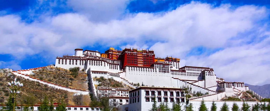
After breakfast, depart from Nyingchi and drive onto the Lam La Highway, which is known as the "most beautiful and high-grade highway in Tibet", at both ends of about 400 kilometers, on one side of the Tibetan Jiangnan, on the other side is the holy city of Lhasa. From snow-capped mountains, forests, rivers, grasslands to Tibetan-style villages and Tibetan countryside... Along the way, you can feel the multifaceted Tibet. Arrive in Lhasa to end the beautiful Sichuan-Tibet Line tour, wandering the streets of Lhasa, passing through countless Chinese, foreigners, pilgrims, travelers, yellow skin, white skin. Friends who like photography can go to shoot the Potala Palace, and the Cloth Palace Square and the Yaowang Mountain Observation Deck are the best places to shoot the night view of the Cloth Palace.
Tips:
Arrival time in Lhasa is around 12:00, if you leave Lhasa on the same day, it is recommended to book a flight return after 15:00 pm.
Don't get lost in the raider map, don't wander at the intersection of the city, your life is worth a time in the city of Aden