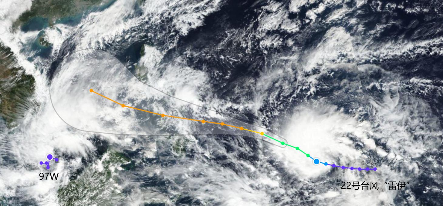
In December, the tropical disturbance activity in the marine area did not weaken, but increased, and a new typhoon embryo appeared, coded at 97W.
According to the data, this typhoon embryo is a typhoon embryo located in the South China Sea region of China, with a wind speed of 15KT, equivalent to 7.5 m/s, and a central air pressure value of 1005hpa. Will that be Typhoon Maleka the 23rd of this year? In terms of position, it is largely unlikely, and most of the agencies show that the typhoon embryo is moving westward.
It means that it may develop in the direction of the Bay of Bengal, and if it is really formed, there is still a probability of forming a cyclone in the Bay of Bengal, and the probability of forming a typhoon in the South China Sea is low. Therefore, we can only continue to observe. For our country, there is no impact for the time being.
And now may bring impact is this year's No. 22 typhoon "Rey", the typhoon has reached a level 10 state in the northwest Pacific region, and then will continue to move in a north-westerly direction, the intensity is gradually increasing, China is expected to reach the level of 16 super typhoon around December 16, and directly "sweep" the central Philippines.

Therefore, friends in the Philippines should be vigilant, and will enter the South China Sea for development. After entering the South China Sea, what direction will it develop has become a matter of controversy, and some institutions predict that they will land directly in the direction of Vietnam, and some institutions predict that they will approach the direction of South China.
However, even if it is close to South China, there is no need to worry too much, because the temperature in the offshore area is extremely low, and a wide range of areas are below 25 degrees, so it is not conducive to the development of typhoons and may disappear quickly.
The China Climate Center temporarily pointed out that it is unlikely to be directly close to South China, and at most it is to transport a wave of water vapor into South China, and bring about the problem of rainfall, which is also dominated by "light rain" for the time being. However, with the continuous "cyclone" moving to China in the later period, the rainfall in southern China may escalate, and the climate center of China is expected to have moderate to heavy rain in eastern Guangdong, Fujian, southern Jiangxi, southern Zhejiang, and Taiwan Island on the 21-23rd, and there will be heavy rain locally.
We look at the situation from the supercomputer, it is indeed because the later cyclone may be in effect, affecting the upgrading of rainfall, so friends in South China need to pay attention to the fact that cold and humid air flow may bring huge fluctuations to see if a new round of changes will occur. However, when typhoons develop, we need to pay attention to a new round of cold air activities. The cold air in December can be said to be "highly active", and a new round of widespread cooling will be launched.
According to the situation of the supercomputer, on December 14, in the northwest of China, the sky over the north has actually appeared "three major air masses", brewing almost. As you can see, although the strength of each cold air mass is not large, as long as there is a mixture of southward impact on China, it will inevitably bring about the emergence of cooling.
Indeed, on December 16, the two relatively strong cold air masses in the north entered the northern region of China, of which the northeast, north China and other places have seen a wide range of cooling.
After that, this wave of cold air mass will continue to go south, from the "cold air mass forward" can be seen, in fact, has reached the southern region of China, to December 18, China's predicted frost line has reached Fujian, so, the country's new round of large-scale cooling has come again, this is no doubt.
Of course, this wave of cold air is so strong southward, from the perspective of air flow, there may also be a certain relationship with Typhoon Rey No. 22 in the northwest Pacific Ocean, constantly absorbing the cold air flow south, accelerating the cold situation in a wide range of areas in southern China, and China expects that the temperature in most parts of the central and eastern regions will drop by 4 to 8 ° C, and the local temperature will be about 10 ° C.
At the same time, as mentioned above, rain may escalate, and the rainfall in local areas may reach nearly 57 mm from the perspective of supercomputing, so the heavy rain may also evolve into "exceptionally heavy rainstorms", which needs to be paid attention to, Guangdong, Fujian and other places are the focus. Many people here may say - it is cold air, typhoons, and heavy rain, and it is "confusing" to summarize it.
There is a new typhoon embryo in the marine area, which has no impact on our country for the time being, and it is expected to move westward. Typhoon Rey No. 22 is continuing to develop, with a probability of becoming a 16-magnitude super typhoon and making landfall in the Philippines, which may enter South China as a cyclone according to the expected situation.
At the same time, there are 3 major cold air masses in the northwest and northern belts, which are expected to go south, so that China will have a wide range of cooling, and it is expected that around December 18, the frost line will reach Fujian, China.
At this time, Typhoon Rey No. 22 is still developing, and may accelerate its southward direction when the cold air is moving south, forming a larger cold zone. After that, Typhoon Rey No. 22 is expected to be dominated by cyclones when it is close to south China due to development restrictions.
At the same time, warm currents, cold air in the southern region of China may form a "docking", then the rainfall in a large area of South China may be upgraded, China's meteorological center is expected to have heavy rain on the 21-23rd, but it may be stronger, this is the general situation.