On the weekend, for two days (February 12 to 13), the mainland rain and snow range is wider, covering more than 20 provinces, and the intensity will also increase. Parts of north China and other parts of the north will have moderate to heavy snowfall and local heavy snowfall; in parts of the south, there will be moderate to heavy rain.
The snowfall in the north of the weekend focuses on the impact on north China And the rain in the south is stronger
This week, the mainland rain and snow weather is still frequent, the southern large-scale precipitation continues to "online"; the northern snowfall has also increased from the 10th, and today parts of the northeast and northwest will be affected by snowfall.
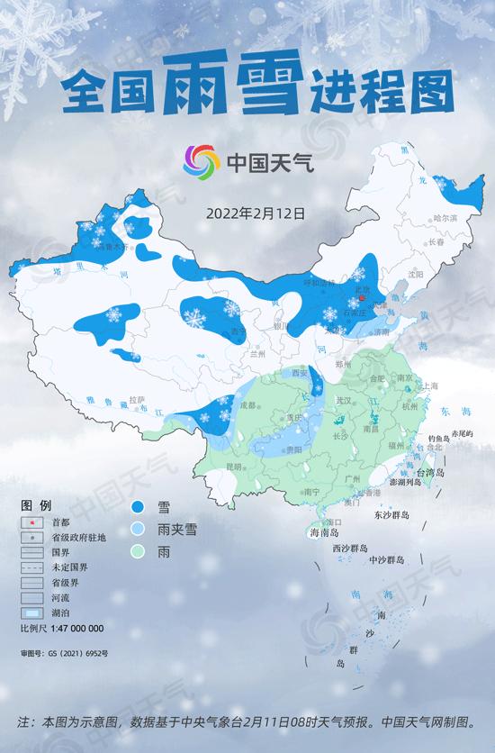
On the weekend, the center of gravity of snowfall in the north will be "transferred" to North China and other places, and the Central Meteorological Observatory predicts that there will be moderate to heavy snow in parts of Beijing, Tianjin, north-central Hebei, northern Shanxi, and the south-central part of Inner Mongolia, and there will be blizzard locally.
According to Zhou Ying, a meteorological analyst at the China Weather Network, during the day on Saturday, the cold air moved east, with the water vapor in the south, and snow fell in the mountains of Beijing and Tianjin in the north-central hebei; at night, with the arrival of the short wave trough, the power conditions in north China were strengthened, and with the help of the east wind, the most obvious period of the snowfall process was officially opened, of which there was heavy snow in parts of central Hebei and central Tianjin.
On Sunday, the power conditions remain strong, while easterly and southerly winds will converge in central Hebei, resulting in heavy to heavy snowstorms in parts of northern Shanxi, north-central Hebei, Beijing, Tianjin and other places.
In large cities, Tianjin and Shijiazhuang will turn on snowfall mode during the day on Saturday, and Shijiazhuang will start to drift snow around noon, the largest time will appear in the afternoon to the evening, and the snow will continue to fly on Sunday until the morning of the 14th. Tianjin also began to snow during the day on Saturday, but the largest period of magnitude may be from Sunday night to the morning of the 14th, and the snow will be more obvious in the morning of the 14th, so we plan the travel time in advance.
At the same time, the rainfall in the south will also increase, and there will be moderate to heavy rain in parts of Guangxi, Hunan, Jiangxi, Zhejiang, Fujian and other places, of which the night of the 12th to the day of the 13th is the main precipitation period.
A new round of widespread rain and snow weather will cover most of the mainland on weekends, but the causes of rain and snow vary from north to south. Zhou Ying introduced that the recent frequent short-wave troughs in the north have combined with the water vapor brought by the east wind on the ground, resulting in snowfall. The process has the characteristics of a wide range of snowfall, a long duration, and a large cumulative snowfall in some areas. In the south, due to the continuous "water delivery" of the south branch, the precipitation lasts for a long time, and the round after round is seamless.
North China weekend temperatures will "plummet" There will still be snowfall next week
Affected by snowfall and cold air, the weekend temperature in North China "rapid drop", yesterday the maximum temperature in Beijing, Tianjin, Shijiazhuang have exceeded 10 ° C, the weekend two days will quickly drop to the freezing point, the public please pay attention to timely adjustment of clothing, do a good job of cold and warm measures, beware of cold, while paying attention to prevent snow icing and low temperature, low visibility weather on traffic and other aspects of the adverse impact.
At the same time, most of the southern part of the weekend is still low temperature, in large cities, Hefei, Wuhan, Changsha, Guiyang and other places the maximum temperature is only about 5 ° C, the body feels wet and cold, still pay attention to moisture and warmth, rainy days to pay attention to traffic safety.
Looking forward to the later period, from the 14th to the 15th, there was still light snow in central and eastern Inner Mongolia, north China, northeast China and other places, and localized snow; precipitation in the south was significantly reduced and weakened, and the temperature rose. From the 16th to the 18th, there will be a large-scale rain and snow weather process from west to east in the central and eastern parts of the mainland, so please pay attention to the nearby forecast and early warning information and take preventive measures.
(wc source: China Weather Network)
![Wuhan February 2022 blockbuster special room attack! The Beichen Gemdale era has been listed[fig]](data:image/gif;base64,R0lGODlhAQABAIAAAP///wAAACwAAAAAAQABAAACAkQBADs=)