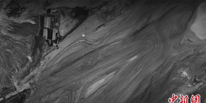
Land Exploration No. 1 Group 01 A star was launched for the first time to obtain images of the Haixi region of Qinghai Province. Courtesy of the Aerospace Academy of sciences
Beijing, 11 Feb (Xinhua) -- The Institute of Aerospace Information Innovation of the Chinese Academy of Sciences (CAS) released a message to the media on the 11th that the land exploration No. 1 group A satellite (LT-1A) synthetic aperture radar (SAR) payload successfully launched half a month ago recently achieved on-orbit imaging for the first time in recent days, with excellent image quality. The acquisition of high-quality images of the first orbit laid a good foundation for the subsequent operation of the land exploration 1 satellite formation.
The land exploration No. 1 Group 01 A satellite payload is developed by the payload development team of the Academy of Space Sciences of the Chinese Academy of Sciences, and the satellite data is received by the China Remote Sensing Satellite Ground Station affiliated to the Academy of Space Sciences. On the evening of February 9, the Miyun Station of The China Remote Sensing Satellite Ground Station and the Kashgar Station successfully tracked and received the downlink data of the A-satellite of the Land Exploration No. 1 Group 01, and completed the real-time reception, recording and transmission of a total of 36.66 GB of data, and the received data were processed normally. So far, the Academy of Aerospace of the Chinese Academy of Sciences has successfully completed the task of land exploration Of the First Group 01 A satellite payload development and data reception.

Testers from the load development team of the Academy of Space Research of the Chinese Academy of Sciences are installing a dual-star phase synchronous test antenna. Courtesy of the Aerospace Academy of sciences
Chinese Academy of Sciences Aerospace Academy of Sciences said that SAR is a microwave imaging radar system, together with the Optical Imaging Department to form remote sensing satellites to achieve high-resolution Earth observation of the two important payloads, SAR can not be limited by light and climatic conditions, all day, all day long, all-weather high-resolution microwave photos, and even through the shallow surface or sparse vegetation to obtain covered information, in the field of Earth observation has irreplaceable uniqueness.
As the first airborne SAR and spaceborne SAR research and development unit in China, the Academy of Space Sciences of the Chinese Academy of Sciences is the incubation base of China's spaceborne SAR theory and key technologies, and has long been committed to the technical research and development of China's spaceborne SAR. Since 2011, the payload development team of the Academy of Aerospace Research of the Chinese Academy of Sciences has carried out tasks such as land exploration-1 satellite planning, key technology research and engineering development in the whole process, and vigorously promoted the development of SAR technology.
Schematic diagram of the SAR interferometry mode of the Land Exploration I satellite. Courtesy of the Aerospace Academy of sciences
The Synthetic Aperture Radar payload of the Land Exploration I satellite is China's first Earth observation system with differential interferometry as its main task. In order to ensure the accuracy of satellite measurement, the payload research team of the Academy of Space Research of the Chinese Academy of Sciences has developed a high-precision SAR phase internal scaler, so that the land exploration satellite SAR can not only accurately measure the short-term change of phase during the start-up imaging process, but also accurately measure the long-term change of phase during the whole life cycle of the satellite. Based on this, after obtaining multiple radar images in the same area, it is expected to obtain deformation information with millimeter-level accuracy of the surface, which has great application potential in the monitoring of land surface deformation measurement, topographic mapping, and geological disasters (landslides, mudslides, earthquakes, volcanoes) and so on.
The LANDSA-1 SAR payload also has multi-modal polarization imaging capabilities that can measure information such as material properties, geometry and orientation, and has great potential for obtaining richer feature information. In addition, the load development team of the Academy of Aerospace Research and Space Institute of the Chinese Academy of Sciences proposed and broke through a series of new technologies, which can increase the start-up time of the satellite SAR system by 22%, improve the efficiency and performance of satellite SAR observation, and improve the quantitative remote sensing business capabilities of land, disaster reduction, surveying and mapping, forestry and other industries.
China remote sensing satellite ground station Kashgar station first orbit data receiving mission site. Courtesy of the Aerospace Academy of sciences
It is understood that the land exploration satellite No. 1 is the first satellite mission launched in China's "Medium- and Long-term Development Plan for National Civil Space Infrastructure (2015-2025)", including two advanced SAR satellites A and B. The successful launch of the A star on January 26, 2022, will form a constellation with the recently launched "Twin Brothers" B star, and the double stars will fly together at a distance of kilometers, and the ground will be imaged through the dual-base SAR interference system to obtain surface elevation information, and one of its typical applications is to measure forest biomass and provide an effective technical means for carbon cycle monitoring. (End)