In January 2021, there was a massive eruption of the Tonga volcano, and countries around the world used their satellites to shoot "from all angles". The mainland has also released satellite photos of the eruption of the Tonga volcano, which has aroused a lot of people's heated discussion. That is, many people think that the satellite photos taken by China seem to be "inferior to people". The quality of the photos looks very poor, but it is impossible to take clear photos. It seems that China does not seem to have a decent satellite that can shoot high-definition and ultra-clear satellites.
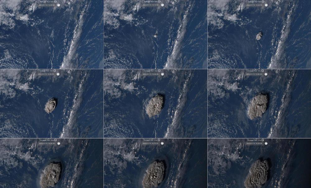
Of course, although we have also carried out "science popularization" instructions, from the published satellite photos, it is also a clear photo, the Photos of the eruption of Tonga Volcano taken by China Fengyun 2F and Fengyun 4B, animated pictures, etc., are very clear, but there are still people who feel poor. What needs to be explained here is that everyone's understanding of satellite photos may be biased from a single point of view. And the role of each satellite is not the same, the shooting angle is not the same, and everyone may also see a different state. No, after this incident, the Jilin No. 1 satellite high-definition overlooking the Chinese field map, triggered a heated discussion, this news once again raised China's satellite discussion to a new height.

Here we are not boasting, but also speaking according to the facts, but also once again proved a problem, that is, China also has a very powerful satellite, but also can take high-definition satellite images, which once again shows the satellite map of the Tonga volcano, we may only see a one-sided problem. Let's take a look at what the satellite map is like this time.
First of all, let's understand what the background of Jilin No. 1 is. "Jilin No. 1" is actually what we call the Jilin No. 1 commercial satellite and the "Jilin No. 1" satellite constellation, which is an important optical remote sensing satellite constellation on the mainland.
The "Jilin No. 1" satellite coverage capacity is known - has covered a total area of 133 million square kilometers, with the ability to update the map globally, the country has the ability to update three times a year, the satellite can complete the automatic identification of buildings, roads, water bodies, forests and different types of crops online, the identification accuracy of more than 95%. In January 2022, it was announced that 10 Jilin No. 1 satellites would be launched again from China's Wenchang Satellite Launch Site, and that they would be networked with 31 Jilin No. 1 satellites in orbit to provide enhanced services.
Among this batch, there are three numbers that are the most concerned, "Shaoguan No. 1" ("Jilin No. 1" high score 03D15 stars), "Wenchang Supersurgical No. 2" ("Jilin No. 1" high score 03D16 stars) and "Wenchang Supercomputer No. 3" ("Jilin No. 1" high score 03D17 stars), which have the characteristics of obtaining static push-sweep images with a resolution better than 0.75m and a width greater than 17km, which have the characteristics of low cost, low power consumption, low weight and high resolution.
And standing on the entire "Jilin No. 1" constellation series of satellites, in fact, the resolution is better than 0.75m image, this is not the best moment, the detailed inspection state is the maximum value of 0.5 meters limit value, and is limited to the commercial satellite allowable resolution limit value, this state of the usual zebra crossing white road width can be identified, you can think about it, the non-commercial state is not stronger. Therefore, the constellation of the Jilin No. 1 satellite is still relatively strong.
Of course, whether it is strong or not is not up to us, it is necessary to have practical evidence. From the perspective of mainland individuals, the shooting of Jilin No. 1 that is really well known and recognized by everyone may be the shooting of the US Naval Shipyard and the Rio Olympic Venues.
The U.S. Navy Shipyard was released in 2016, and this set of photos is clearly visible to U.S. aircraft carriers, destroyers, etc.
The Rio Olympic venues were also announced in 2016, and the Brazilian aircraft carrier near the venues can be clearly seen in the picture.
So, looking back, are the photos taken by China's satellites poor? Obviously impossible. It's not as bad as everyone says. The high-definition view of the Chinese field map of the Jilin No. 1 satellite this time was taken using the 100 million pixel lens of the "Jilin No. 1 Constellation" at a height of 600,000 meters.
For example, the Wudalianchi, Dammed Lake landform and volcanic landform can be clearly seen, and even the "water wave map" formed in the satellite map can be clearly seen.
The second is the large yellow croaker cage breeding base photographed in Sanshawan, Fujian Province, countless breeding cages are arranged in an orderly manner, boats, houses and villages floating on the sea surface can be clearly seen, even if it is the "tail water wave" generated by the "ship" at the stern, you can also see the static "water wave map". So, all very nice photos.
Of course, here we are not saying that our satellite maps are "superior", completely defeated the world's most advanced satellites, here we can only say that our satellites are not so bad, but also belong to high-definition images, and can also obtain high-resolution satellite maps, even if the Jilin No. 1 satellite image is very clear. However, there is still a certain gap from the highest level in the world, with the highest resolution commercial remote sensing satellite in the world reaching a resolution of 0.31 meters, while the U.S. military optical imaging reconnaissance satellite Keyhole-12 reaches 0.1 meters.
Therefore, there is a gap with the most advanced, but here we also have to explain, not necessarily we do not have a satellite that has reached 0.1 meters of accuracy, may have different uses, we just don't know. Even if not, our development is progressing. Therefore, don't use a single satellite map to say that the gap is not a little big. In fact, there is no such state.