"Cold" is undoubtedly the theme of the cold winter moon, the northerners feel dry and cold, the north wind whistles to the face; while the southerners feel wet and cold, and the cold rain knocks on doors and windows.
Can cold in different places be "seen"? Of course. In space, the "clairvoyance" of satellites can "see" cold air from a distance. Its incomparably wide field of view allows us to clearly and intuitively see the changes in the cold air when it comes.
The following precious satellite cloud maps are the space perspectives of the two wind and cloud meteorological satellites. Polar orbiting meteorological satellites at an altitude of about 900 kilometers and geostationary meteorological satellites at an altitude of about 36,000 kilometers give the last cold air in 2021 the most dazzling "selfie image" and the most agile "live image".
What does cold air look like in the eyes of the Fengyun Meteorological Satellite?
The following pictures show the appearance of a strong cold air in the eyes of the satellite at the end of last year: Figure 1 is cold air in the eyes of the FY-3E dawn star: Wind radar shows that the wind speed in the western Bohai Sea in the north exceeds 20 m/s, indicating that a cold air has begun to move south.
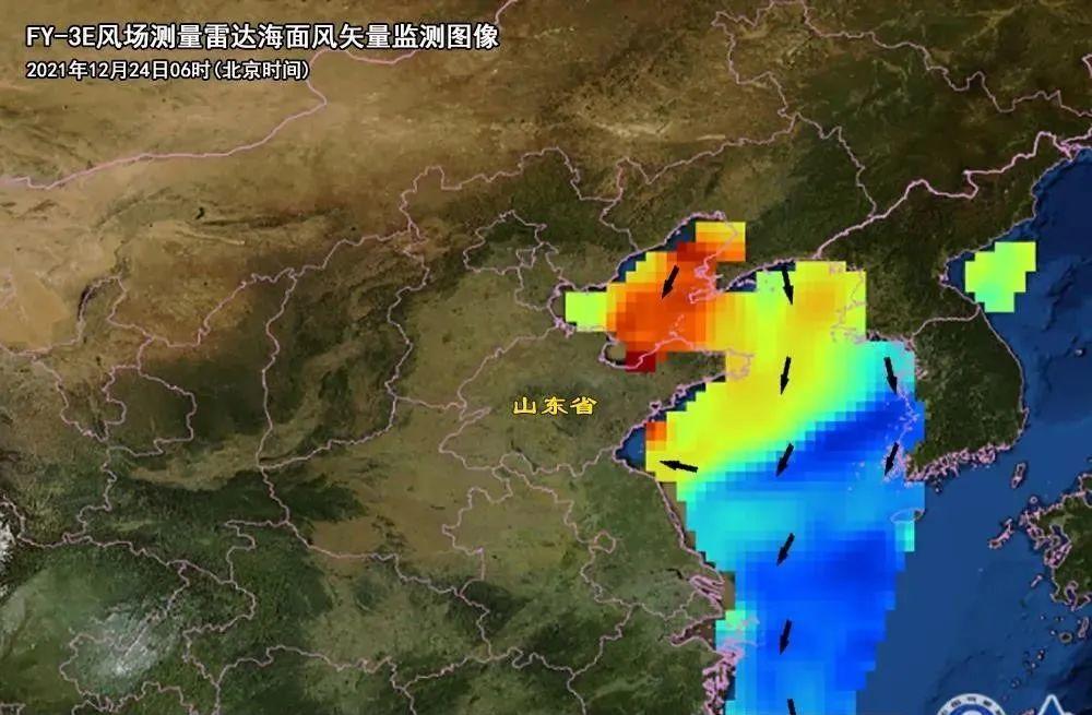
Figure 1: FY-3E Wind Field Survey Radar Sea Surface Wind Vector Monitoring Chart
Figure 1 is an area map, so the resolution is a bit low, and it also comes with a mosaic. In contrast, in the global observation, the wind field in the eyes of the Fengyun satellite is the appearance of Figure II, which looks much more delicate.

Figure 2: The first lunar average product image of the oceanic wind field on the FY-3E star
Figure 3 is what the Fengyun-3 D polar orbit meteorological satellite looks like: the image shows a stunning striped cloud (also called cloud street, horizontal convection roll), which is often formed by cold cold air being blown onto a relatively high temperature ocean and being "heated and humidified", and can only appear when strong cold air enters the sea in winter.
Figure 3: True color monitoring map of FY-3D meteorological satellites
The same cold air is what Figure 4 looks like in the continuous monitoring of the Fengyun 4 multi-channel sweeping radiometer. One cloud map after another, dynamically broadcasting the cold current of "moving south in a big way", does not look like the "flying stream down three thousand feet" depicted in Li Bai's poem?
Figure 4: Animated image of true color monitoring by the FY-4A meteorological satellite
Obviously, in the eyes of the satellite, the static cold air shows a landscape painting of the beauty of the landscape, sea, land, white clouds, and snow mountains; the dynamic cold air fully expresses the strength of the cold tide, the speed and the beauty of the clouds and flowing water, just like a "water-like flowing cloud" live broadcast of the waterfall hanging in the front river.
From the cold wave in the north, to cross the sea, over the mountains, all the way south, fengyun satellite like a human mother to pay attention to the growth of their children, all-round tracking and monitoring of the production, movement, strength and weakness, scope of cold air, at any time for the earth to send back the weather weather cold and warm information.
How does Fengyun Satellite know that the cold wave is "coming" and "leaving"?
Fengyun satellites' ability to monitor cold air stems from their "clairvoyance": advanced satellite payload observation instruments.
At present, there are eight Chinese Fengyun satellites on duty in the sky. They stay up 365 days a year and are on duty 24 hours a day to help us monitor all kinds of meteorological information about the Earth and the atmosphere.
Among the many observation tools carried by the eight satellites, there are several advanced instruments that can effectively monitor cold air:
The first is the "wind field measurement radar", which can actively obtain information on the wind speed and wind direction on the surface of the ocean, and the accuracy is very high, monitoring the cold air across the sea is not a problem, the previous figure one and two are the pictures taken by them.
The "wind field measurement radar" in the eyes of the "wind and clouds" looks like the flow of blood in our human capillaries, it is the first time that the mainland Wind and Cloud Satellite actively detects the "wind" information of the instrument, it can be said that the wind and cloud measurement of the Wind and Cloud Satellite measurement "wind" measurement "wind and cloud" the original intention and long-cherished wish.
The second is the "multi-channel scanning imaging radiometer", which can provide various satellite cloud maps such as daytime, nighttime, water vapor distribution, etc., intuitively showing the appearance of cold air in the south of the south such as different intensities, ranges, origins, etc., and can also capture dynamic information such as cloud movement through minute-level picture synthesis, which is an artifact of cold air selfie and live broadcast, and the previous figure three and four are the static and dynamic pictures they take.
"Multi-channel scanning imaging radiometer" is like the doctor's common "color ultrasound" for patients to take pictures, with "Holter" monitoring and recording of patients' ECG activity, it can scan a single image of cold air and continuously monitor the whole process of cold air in daily work conditions and live broadcast back to the ground in real time.
Doctors judge the patient's physical condition based on "color ultrasound and electrocardiogram", while satellite meteorological scientists diagnose the intensity, speed, range and other information of cold air from the "satellite cloud map" data, providing an important scientific basis for cold air forecasting.
The third is the "Atmospheric Vertical Detector", which can monitor temperature change information at different heights, and as long as the temperature is cooled, it will have a good response near the ground.
The function of the "Atmospheric Vertical Detector" is similar to that of the "PET-CT", an instrument that performs CT scans of the whole body, and can perform diagnostic scans of the atmosphere at different heights, and obtain information on temperature reductions from the ground to the top of the troposphere.
It is worth mentioning that the mainland is the first country in the world to put the "atmospheric vertical detector" and the "multi-channel scanning imaging radiometer" on a geostationary satellite platform at the same time and successfully launched it into a geostationary orbit of 36,000 kilometers.
These precision instruments are "the best at observing cold air" and are also the soul of the country's heavy equipment of the Fengyun Meteorological Satellite.
Figure 5: 24-hour temperature change map of different altitude layers of FY-4A meteorological satellite vertical detector (degrees Celsius)
Figure 5 is the same cold air, in the eyes of the satellite "PET-CT". The longitudinal axis of The Presse refers to the atmospheric pressure, related to altitude, the smaller the number, the higher the altitude, 1000 hPa corresponds to the surface, 850 hPa corresponds to the average altitude of about 1500 meters, and 300 hPa corresponds to an average altitude of about 9000 m.
When cold air comes, there will be different degrees of cooling at different heights, and the lower the height, the greater the cooling amplitude. At about 1500 meters above the top of the near-ground boundary layer, it is important to determine the cooling amplitude of the lower and middle layers of the troposphere and the strength of cold air.
It is these "clairvoyance" instruments carried by the Fengyun satellite that transmit the first-hand cold air information of real-time monitoring back to the ground in time, ensuring the forecaster's accurate prediction of the "coming" and "going" of the cold wave.
As early as 1969, Premier Zhou called for "we must build our own meteorological satellites", since then more than half a century, China's Fengyun satellites from scratch, from testing to business, from the first generation to the second generation, from the following to running and running to some of the leading, has launched 19 satellites, currently 8 are running in orbit, providing monitoring data and service products for 121 countries in the world.
Whenever you look up at the sky, the weather satellites are overhead, diligently shooting one beautiful and practical cloud map after another back to the ground!
Author: Cao Jing
Photo source: National Satellite Meteorological Center Jia Xu
Editors: Emeria, You Zhiyou
This article is from the fruit shell and may not be reproduced without authorization.