Administrative divisions of Datong City (Part 2)
Hunyuan County, in the northeast of Shanxi Province, the western foothills of Taihang Mountain. It belongs to Datong City. It has an area of 1,968 square kilometers. It has a population of 238,000. It administers 6 towns and 12 townships. The county people's government is stationed in Yong'an Town. The Western Han Dynasty was in present-day Xizhi County, which belonged to Yanmen County. Abolished at the end of the Eastern Han Dynasty. The Western Jin Dynasty re-established Chengxian County. The Northern Wei Dynasty was changed to Chengshan County, which belonged to Fanqi County. Northern Zhou was abandoned. In the early Tang Dynasty, it was a territory in Yunzhong, and later dissolved into Hunyuan County, which was named because it was located at the source of the Hun River and belonged to Ying Prefecture. In the Fifth Dynasty, tang dynasty changed to Hunyuan County, and later restored to Hunyuan County. Liao belongs to Ying Prefecture. In the second year of Jin Zhenyou (1214), hunyuan prefecture was established in the county. Huanyu Tongzhi: Hunyuan Prefecture "takes the name of Hunyuan River". In the fourth year of the Yuan Dynasty (1267), Mongolia was incorporated into Hunyuan Prefecture and belonged to Datong Road. The Ming and Qing dynasties belonged to Datong Province. In 1912 the state was abolished as a county. In 1914, it belonged to Yanmen Road. In 1927, it was directly under Shanxi Province. In 1949, it belonged to Chahar Province, in 1952 it belonged to Yanbei Special District of Shanxi Province, and in 1956 it belonged to Jinbei Special District. It was merged with Guangling County in 1958 and divided in 1959. In 1961, it was restored to Yanbei Special District, in 1979 it belonged to Yanbei Special District, and in 1993 it belonged to Datong City. It is located at the foot of The Heng Mountain in the north. The Hun River, Tang River, Liu River, Dayu River and Wang Qianzhuangyu River pass through the territory. It has a moderately temperate semi-arid climate. Agricultural products are mainly corn, millet, yarrow, beans, potatoes, oil crops. Astragalus is abundant. Minerals include coal, iron, copper, gold, silver, sulfur, fluorite and so on. Industries include coal, electric power, metallurgy, machinery, ceramics, building materials, wire rod, chemical industry, winemaking, textiles, medicinal materials and so on. The Dalai and Shuowei highways pass through the county. Places of interest include Beiyue Hengshan Mountain, Hanging Temple, Brick Pagoda of Yuanjue Temple, Yong'an Temple, Chestnut Cemetery, etc.
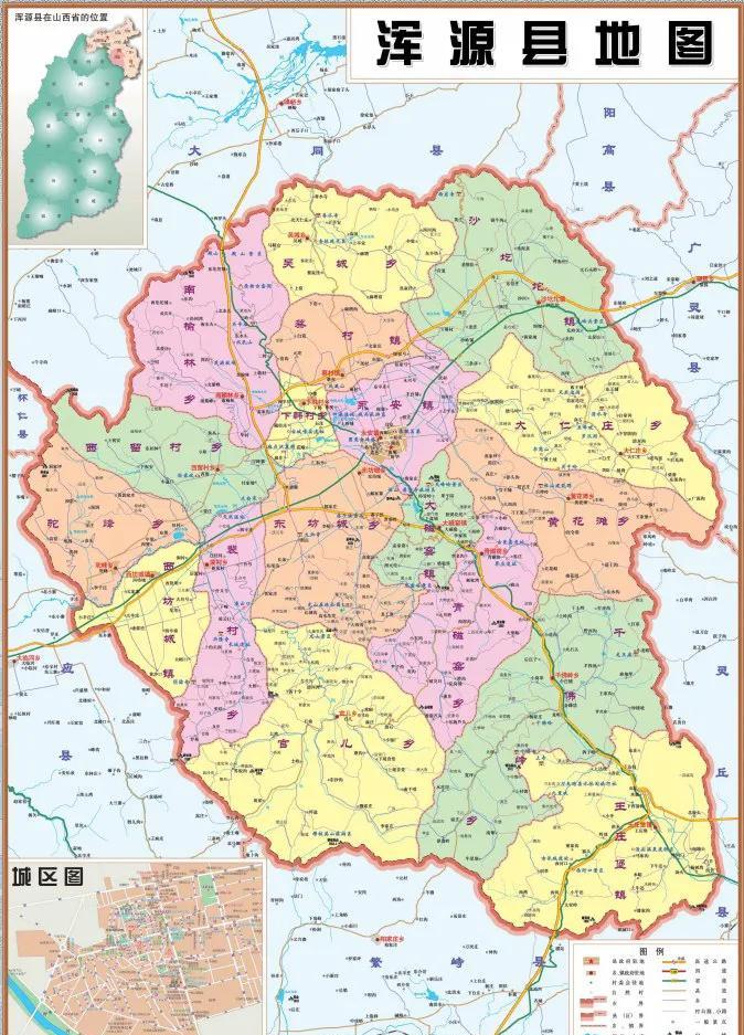
Map of Hunyuan County

North Yue Heng Mountain
Monastery
Brick pagoda of Yuanjue Temple
Eianji Temple
Chestnut Cemetery
Yong'an Township is located in the north-central part of Hunyuan County, Shanxi Province. The seat of the county people's government. The total area is 91.55 km². It has a population of 118,000. The town people's government is stationed in Heshun North Road, with a population of 62,000. The Five Dynasties tang dynasty was the seat of government of Hunyuan County. In 1949, it was chengguan district of Hunyuan County, and in 1958, Chengguan Commune was established. In 1972, Chengguan Town was established, retaining Chengguan Commune, and merged into Chengguan Town in 1984. In 2001, Zhangzhuang Township was incorporated, and Chengguan Town was renamed Yong'an Town. It is named after the Yong'an Temple in the town. It is located in Pingchuan District, the upper reaches of the Hunhe River. The main products are corn, millet, potatoes, beans and vegetables. There are brick and tile, agricultural machinery repair, willow weaving process, brewing, grain and oil processing, traditional Chinese medicine, diesel engine and other factories. The Shuowei and Dalai Highways pass through here. Places of interest include Hengshan Scenic Area, Hanging Temple, Yong'an Temple, Yuanjue Temple, Lijia Tomb, and Confucian Temple.
Map of Yong'an Town
Confucian temple
Xifang Town, in the western part of Hunyuan County, Shanxi Province. The total area is 56.19 km². It has a population of 15,000. The town people's government is located in Xifang City, with a population of 5555. Because it is located in the west of the county seat, it was formerly named Xichafang, and later developed into a small market town and renamed Xifang City. In 1949, it was the third district of Hunyuan County, and in 1953, it was established as Xifang Urban and Rural Area, in 1958 it was changed to a commune, and in 1984 it was changed to a town. It is located in Pingchuan District, south of the Hun River and north of Hengshan Mountain. It produces maize, sorghum, potatoes, wheat and flax. Specialty Jian Village firecrackers. There are brick and tile, agricultural machinery repair, agricultural products processing and other factories. The Shuowei Highway passes through here.
Map of Xifang Town
Caicun Township is located in the northwest of Hunyuan County, Shanxi Province. The total area is 59.68 km². It has a population of 13,000. The town people's government is located in Cai Village, with a population of 9536. Named after the last name. In 1949, it was the eighth district of Hunyuan County, and in 1953, Caicun Township was established, in 1958 it was changed to a commune, and in 1984 it was changed to a town. It is located in the half-river and half-hilly area on the northern edge of the Hun River Valley. The main products are corn, millet, potatoes, sorghum, beans and flax. There are factories and mines such as coal mining, brick and tile, agricultural machinery repair, agricultural product processing, ceramics and so on. The Dalai Highway passes through here.
Map of Cai Cun Town
Shatuotuo Town, in the northeast of Hunyuan County, Shanxi Province. The total area is 177.78 km². It has a population of 25,000. The town people's government is stationed in Shatuotuo, with a population of 3120. Named after the features of the landscape. The tufts are dialects, meaning low hollows. In the seventh year of Ming Hongwu (1374), he set up an inspection department and built a fort. In 1949, it was the fifth district of Hunyuan County, in 1953 it was established as ShatuoTuo Township, and in 1958 it belonged to Yangzhuang Commune. In 1961, Sobagawa Commune was established, in 1983 it was changed to Sa Tuo Tuo Commune, and in 1984 it was changed to a town. In 2001, Yangzhuang Township was incorporated. It is located in the hilly mountainous area of the northern section of Hengshan Mountain. It mainly produces corn, potatoes, millet and rye. Specialty astragalus. Coal, iron and phosphorus are abundant. There are factories and mines such as coal mining, brick and tile, and agricultural machinery repair. The Shuowei Highway passes through here.
Map of the town of Shatuotuo
Wangzhuangbao Township is located in the southeast of Hunyuan County, Shanxi Province. The total area is 189.5 km². It has a population of 17,000. The town people's government is located in Wangzhuang fort, with a population of 13,000. Because of the surname, it was named Wangjiazhuang, and it was named after the ming station and built a castle. In 1949, it was the sixth district of Hunyuan County, and in 1953, Wangzhuangbao Township was established, in 1958 it was changed to a commune, and in 1984 it was changed to a town. In 2001, Xihekou Township was incorporated. It is located in the southern foothills of Hengshan Mountain, hilly mountainous area. It mainly produces corn, millet, millet, potatoes, beans, apricots, peaches, apples and grapes. The Dalai Highway passes through here. There are places of interest such as Yutou Onsen.
Map of Wangzhuangbao Town
Yutou onsen
Qingci kiln town, in the central part of Hunyuan County, Shanxi Province. The total area is 158.87 km². Population 1.9. The town people's government is located in Qingci Kiln, with a population of 1845. It is famous for its long history of firing ceramics, hence the name. In 1949, it was the fourth district of Hunyuan County. In 1956, qingci kiln township was established, in 1959 it was merged into daci kiln commune, in 1971 it was divided into celadon kiln commune, and in 1984 it was changed to a township. In 2002, Linchang Township was incorporated. In 2021, the town of Daci Kiln was merged and changed to Qingci Kiln Town. It is located in the Shishan District at the southern foot of the main peak of The North Yue Heng Mountain. It mainly produces potatoes, quinoa, beans and flax. There are power plants, coal mines, chemicals, ceramics and other factories and mines. Ceramic products are famous. The Dalai Highway passes through here. There is the famous "Eighteen Views of Hengshan Mountain".
Eighteen views of Hengshan Mountain
Zuoyun County, in the northwest of Shanxi Province, south of the Great Wall, is bordered by the Inner Mongolia Autonomous Region in the north. It belongs to Datong City. It has an area of 1,314 square kilometers. It has a population of 118,000. It has jurisdiction over 3 towns and 6 townships. The county people's government is stationed in Yunxing Town. Wuzhou County in the Western Han Dynasty belonged to Yanmen County. Abolition. Northern Wei Dynasty Wuzhou County, belonging to Dai County. Sui waste. In the twenty-sixth year (1393) of Ming Hongwu, the town of Shuowei was established and later abolished; in the seventh year of Yongle (1409), datong zuowei was established; in the fourteenth year of orthodoxy (1449), Yunchuan Wei was moved here. In the seventh year of Qing Shunzhi (1650), the two guards merged to change to Zuo Yunwei. In the third year of Yongzheng (1725), wei was set up as a county, called Zuoyun County, and the current site was ruled. In 1914, it belonged to Yanmen Road, and in 1927, it was directly under Shanxi Province. In 1949, it belonged to Yanbei Special District of Chahar Province. In 1952, it belonged to Yanbei Special District of Shanxi Province. In 1958, Zuoyun and Youyu counties were merged into Zuoyun County, which belonged to the Jinbei Special District. In 1961, the two counties were divided and belonged to the Yanbei Special District. In 1967, it belonged to yanbei region. In 1993, it belonged to Datong City. It is located on the northeastern edge of the Shaanxi Loess Plateau. The Shili River, the Qimo River, the Yuanzi River, and the Silt River pass through the territory. It has a moderately temperate semi-arid climate. Agricultural products are mainly millet, beans, yarrow, potatoes and oil crops. Minerals include coal, clay, limestone and so on. Industries include coal, chemicals, building materials, electric power, machinery and so on. National Highway 109 and Shiliang Highway pass through here. Places of interest include the Ming Great Wall, the Han Tombs, and the Jiajiayao Ruins.
Map of Zuoyun County
Ming Great Wall
Yunxing Town, in the central and western part of Zuoyun County, Shanxi Province. The seat of the county people's government. It has an area of 134.07 km². It has a population of 58,000. The town people's government is located in Zuoyun County South Street, with a population of 50,000. The Western Han Dynasty was the county seat of Wuzhou. Northern Wei was ruled by Wuzhou County. In the third year of Qing Yongzheng (1725), he was the governor of Zuoyun County. In 1949, it belonged to the urban area of Zuoyun County, in 1953 it was established as Chengguan Township, in 1958 it was changed to a commune, in 1976 it was divided into Chengguan Town and Chengguan Commune, in 1984 it was divided into Chengguan Town and Chengguan Township, and in 1990 it was merged to form Chengguan Town. In 2001, it was renamed Yunxing Town, which was renamed Yunzhou in ancient times, taking the meaning of revitalization. It is located in the middle reaches of the Shili River in the loess hilly and gully area. It mainly produces rye, millet and potatoes, and is rich in flax and vegetables. There are coal mines and bricks, tiles, electric porcelain, building materials, grain and oil processing plants. National Highway 109 and Shiliang Highway pass through here.
Map of Yunxing Town
Queershan Township, in the northeast of Zuoyun County, Shanxi Province. It has an area of 54.32 km². The population is 6665. The town people's government is located in Queershan, with a population of 1343. It is named after the village's location on Queer Mountain. In 1949, it belonged to the third district of Zuoyun County. In 1953, Queershan Township was established, in 1958, Xiaobaobao Commune was established, and in 1984 it was changed to Queershan Town. It is located in the loess hilly area. It mainly produces rye, potatoes, peas, and is rich in flax. There are coal mines, lime and other factories. It is a new type of industrial and mining area in the county. There is a special line for the Queershan Coal Transport Railway. The highway leads to Datong, Zuoyun and other places.
Map of Queershan Town
Dianwan Town, in the central and eastern part of Zuoyun County, Shanxi Province. The total area is 105.18 km². Population 10,000. The town people's government is located in Ping temple, with a population of 587. Because it is located in the river bend, some people set up shops here, and settled in the village for a long time, hence the name. In 1949, it belonged to the fourth district of Zuoyun County, and in 1953 it was established as Dianwan Township, in 1958 it was changed to Jingergou Commune, and in 1984 it was changed to Dianwan Town. In 2021, Shuiyao Township was incorporated. It is located in the loess hilly area. It mainly produces wheat, millet, millet, potatoes, and is rich in flax. Rich in coal resources, it is a county coal development zone. There is a special railway line for coal transportation in Zhangjia tomb. The highway leads to the left cloud and the large equivalent.
Map of Dianwan Town
Santun Township is located in the northern part of Zuoyun County, Shanxi Province. It has an area of 236.9 km². It has a population of 13,000. The township people's government is stationed in Santun and has a population of 946. Longqing built The Three Tun Fort in three years, the terrain is critical, for the northern border pass, the barrier of the left cloud. In 1949, it belonged to the first district of Zuoyun County; in 1984, Santunbao Commune was changed to Santun Township; in 2000, Hanfang Ta Township and Chenjiayao Township were merged. It is located in the loess hilly area. It mainly produces corn, millet, sorghum, and flax. Granite, basalt, purple sandstone and other resources are abundant. Provincial Highway 210 passes through here. Places of interest and monuments related to the tombs of the Shan han Dynasty, the site of the 12th Kiln Massacre, the location of the division headquarters of the 129th Division of the Eighth Route Army when it went north to resist the Japanese, and the former site of Santai Village, where The commander of the He Long Division and Guan Xiangying lived, and the old lair of Xiangma on Pumice Mountain and the scenic spot of Sky Ridge.
Map of Santun Township
Skyscraper Ridge Scenic Area