Although wildfires are a long-standing disaster in California, severe droughts, combined with extreme temperatures, have exacerbated the severity of this year's wildfire season. As of Sept. 14, more than 7,000 wildfires have been recorded, burning more than 900,000 hectares statewide.
The Dixie Fire, the largest wildfire of the 2021 wildfire season and the second largest on record in the state, has burned more than 388,000 hectares of major woodland and destroyed more than 1,200 buildings in its path. The blaze, named after the road that caught fire, began on July 13 in the Feather River Gorge and was only 75 percent under control as of Sept. 14.
As thousands of firefighters continue to battle the blaze, some are turned to help navigate the nearby Caldeau fire, which has burned more than 88,700 hectares of woodland, threatening communities near Lake Tahoe before crossing the state's border into Nevada.

This map shows the Wild Hot Spot area on the west coast of the United States in 2021. Further north, some Canadian provinces, including British Columbia, have also experienced fierce fires since the end of June.
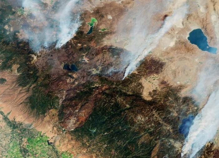
The Copernican Sentinel-2 mission has been used to image these fires. Each of the Sentinel-2 satellites carries only one instrument — a high-resolution multispectral imager with 13 spectral bands. This photo was taken on September 1, and smoke and burn marks from the Caldo and Dixie fires are clearly visible.
According to the Copernican Atmospheric Monitoring Service (CAMS), smoke from the North American fires has crossed the continent and spread across the Atlantic Ocean to Europe, but due to its altitude in the atmosphere, it is unlikely to affect Europeans. However, smoke has affected air quality in the United States and Canada, where smoke is closer to the ground.
The Copernicus Sentinel 5P satellite is dedicated to monitoring air pollution by measuring a variety of trace gases that affect the air we breathe. Images taken on August 30 showed the presence of aerosols in the atmosphere caused by fires. These plumes continued to fly eastward, through the United States and even to Europe.
Claus Zehner, ESA Copernicus Sentinel-5P Mission Manager, said: "Copernican satellites like Sentinel-2, Sentinel-3 and Sentinel-5P can detect fires at point sources on the one hand, and monitor the movement of emitted air pollutants in different states in the United States and even on another continent such as Europe." ”
As the fires continued to burn, hot and dry conditions and predicted thunderstorms prompted officials to issue warnings in parts of the state's northwest coast.
Climate change is considered a key driver of this trend. In a recent report by the United Nations' Intergovernmental Panel on Climate Change (IPCC), scientists concluded that there is a clear link between human activities and global warming. The report notes that observations show an increase in droughts and fires in the western United States, and this trend is expected to continue in the future.