Today's itinerary is ready to visit the Tang Dynasty relics - Stone City, and the Panlong Ancient Road that swept the whole network, in view of the previous experience, through the Taxian Visitor Center Hall, we went in to inquire about it, this move is really wise: due to the epidemic situation has closed the Stone City, winter snow reasons closed the Panlong Ancient Road, heard the news, feel blinded. Nowadays, there are basically no tourists, a female staff member saw us from afar sincerely and commendably, very enthusiastically introduced us to the apricot blossom village and the Aral grass beach at the foot of the stone city, after a brief discussion, we decided to go to the apricot blossom village 75 kilometers away.
Two cars start from the small city of Taxian one after the other, not far out of the city, see a large open wetland on the right, then get off the car, overlooking the distance, only to see a large area of brown water and grass close to the golden beauty, crisscrossing the creek meandering, countless cattle and sheep scattered everywhere, and the distant snow mountains, white clouds and blue sky blend together, the scenery is extremely beautiful, the memory can only see this image in the TV documentary, but now it is a real real landscape, the kind of breathtaking excitement is indescribable, it turns out that this is the Jincaotan National Wetland Park.
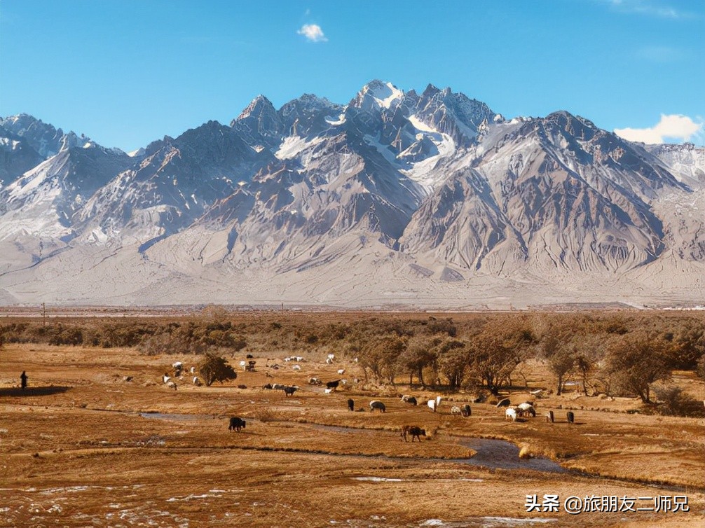

In addition to the bright sunshine, the Tashkurgan River and its tributaries crisscross and flow, the clear springs beat with crystalline water droplets, the distant water grass absorbs the pride of kunlun mountains, tenaciously guards this grass beach, and countless cattle and sheep who are leisurely and free to run.
The village next to the Jincaotan wetland is called Aral, so the wetland is also called Aral Wetland Park. Entering the village, the village road is clean, not far away the herdsmen's white felt houses, hidden in the grass and trees, cooking smoke rises from the ground, there is a policy of favoring grazing, the herders have basically settled, and the gentle and open river beaches have settled pastoral teams. The herders built beautiful brick and wood houses to keep them warm and comfortable. These houses look simple but are actually valuable, there is no wood on the bare plateau, and there is no brick and tile and other building materials, all of which are transported from Kashgar, and the cost is very high. When I met a Tajik uncle, tall, physically strong, very hospitable, but only speaking a few words of Mandarin, I, a southerner who has lived in the hot weather of Guangzhou for a long time, am most concerned about asking what is the maximum summer temperature here? He replied: Twenty-five degrees or so, envying me.
After lingering for a long time, the two gold medal photographers finally collected the troops at our urging, put away the photographic equipment, and continued to drive along the 613 county road to Xinghua Village.
County Road 613, a county road from Ta County to Shache. This is a secret border in southern Xinjiang that few people dare to walk to this day. The mountain is high and the road is dangerous, and walking this road will have a deep experience. After driving this road, there is no road that dare not go, this place was the place where Xuanzang Returned to the East a thousand years ago, and in the depths of the Kunlun Mountains, Master Xuanzang once described this ancient road like this: "Go down to the East Ridge donggang in the east, climb the Dangerous Ridge and cross the Cave Valley; the creek path is dangerous and blocking the wind and snow one after another, and the onion ridge is more than eight hundred miles out of the Green Ridge to the Wu Que Country." "This road winds the mountains, crosses the bridge, and even crosses the cliffs. Some sections are almost the width of a car, and on one side of the hill you often see piles of rubble collapsing, sometimes huge rocky mountains with rocks hanging overhead, and on the other side is the rushing Yarkand River.
"In hell, eyes in heaven", described is this Tasha ancient road, along the road steep, the scenery changes with the trend, the beautiful scenery instantly as promised, only to see the distant snow mountains, near the blue lake, the unique mountain appearance of the plateau, blue sky and white clouds, floating clouds in the sky leisurely, gently stretching, slowly moving, so leisurely. This is the Shimosakachi Reservoir, Takashi gorge Ping Lake, and the blue-blue lake water, which is like a sapphire in the mountains.
At this time it is more than five o'clock in the afternoon, there are more than 30 kilometers away from Xinghua Village, due to the bumpy mountain road, there is already a friend who has a high reaction to feel more uncomfortable, dizzy and vomiting, seeing her discomfort, we feel the same, decided to return to the small town of Ta County on the same road, no longer go. The view is beautiful, but friends are more important.
On October 27th, after staying in the small town of Taxian for another night for breakfast the next day, we set off for Shache, Which belongs to the Kashgar region, due to prevention and control, we do not take the Tasha Ancient Road to Shache, because some of the roads do not belong to the Kashgar region, we can only walk back to the 314 National Highway section in the direction of Kashgar, and then turn into Tuhe Expressway to Shache, the journey is 420 kilometers, everything is smooth plus the checkpoint stay time has walked for nearly 10 hours, and finally arrived at Shache after more than 9 p.m. after passing through heavy checkpoints.
(To be continued...) )
Note: Original graphics, reprints must indicate the source, reprinted any pictures, text paragraphs shall not be used for commercial purposes, violation of the mandatory investigation.