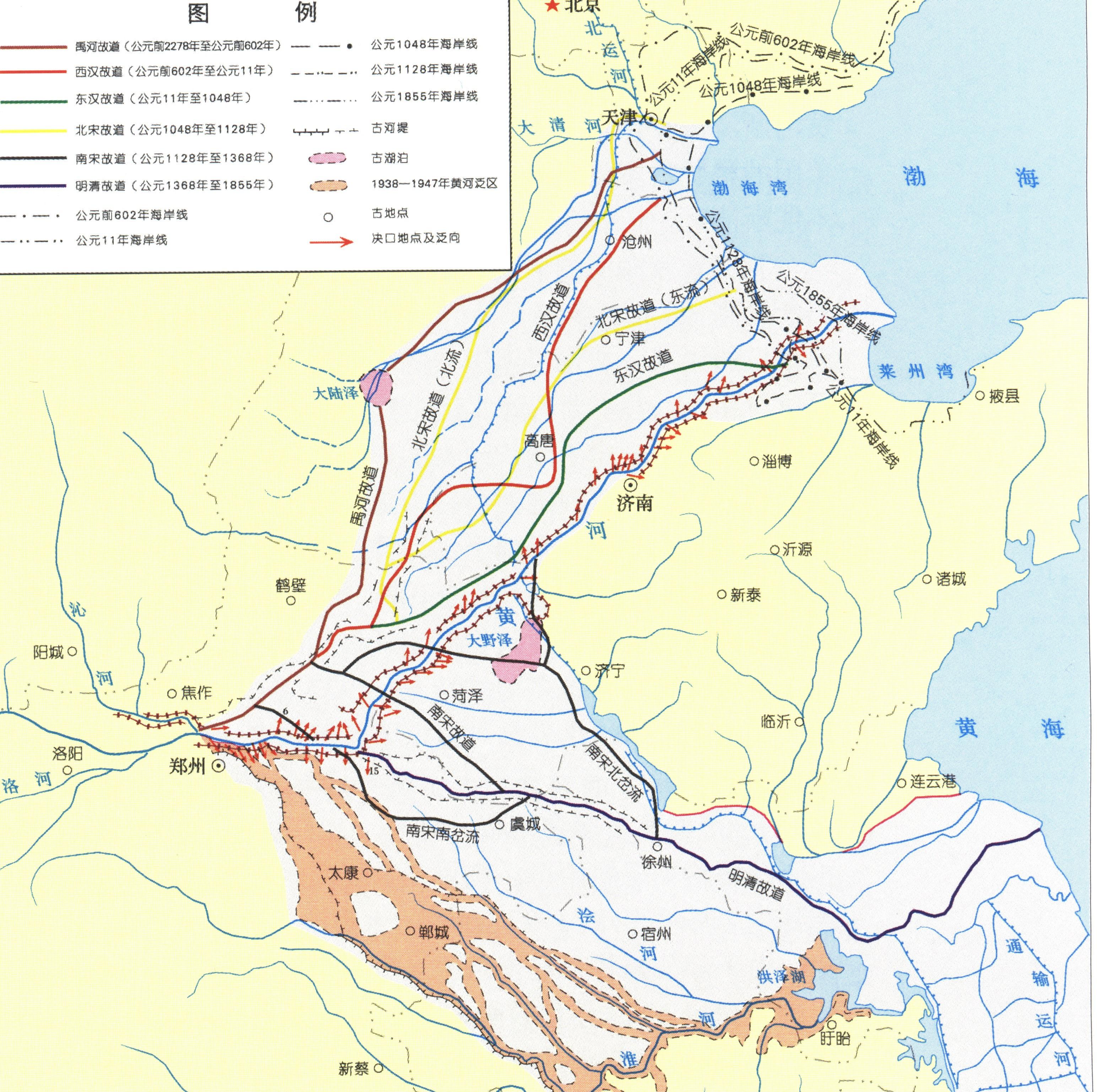
Historically, the Yellow River city has often flooded. According to records, in the 2540 years before 1938, there were 26 large-scale diversions in the lower reaches of the Yellow River, 20 in Henan; of which 7 diversions had a huge impact, 5 occurred in Henan, and the diversion range was as far north as Tianjin and south to Jiangsu and Anhui, reaching 250,000 square kilometers.
Schematic map of the diversion of the lower reaches of the Yellow River
The earliest record of the course of the Yellow River can be found in the Shangshu Yugong, which describes the Yu River as the Warring States and its predecessors, the ancient Yellow River, which traveled for more than 1,500 years from the Xia and Shang dynasties to the Western Zhou Dynasty. After the present-day Mengjin exited the gorge, it turned north in mengxian and Wenxian counties, passing through Qinyang, Xiuwu, Huojia, Xinxiang, Jixian, Qixian (ancient Chaoge), Tangyin and Anyang, Handan, Xingtai and other places on the east side, passing through the mainland Ze and scattering into the Bohai Sea. In the Xia, Shang and Zhou dynasties, the lower reaches of the Yellow River were in a natural state, and there were many lakes in the low-lying areas, and after the rivers colluded with the lakes, they were divided into several branches, wandering and spreading, and returning to the Bohai Sea, known as the Yu River in history.

Zhengzhou Yishan Dayu Zhishui sculpture
Since the Western Zhou Dynasty, the climate of the Yellow River Basin has gradually turned cold and dried, the vegetation has gradually decreased, the soil erosion has been relatively aggravated, the sediment content of the river has increased, and the ground on both sides of the Yugong River in the lower reaches of the Yellow River has been continuously silted up, forcing the Yellow River to gradually migrate east and south. Since then, the lower reaches of the Yellow River have generally peaked in Mengjin, reaching Tianjin in the north and Jianghuai in the south, and on the Huang-Huai-Hai Great Plain, they have experienced five large-scale swings from north to south and from south to north.
In the fifth year of King Ding of Zhou (602 BC), the Yellow River underwent the first recorded major diversion. In the late Spring and Autumn Period, the princely states successively built embankments to "defend hundreds of rivers and rivers, each for self-interest." Due to the constraints of the embankment and the high siltation of the riverbed, the Yellow River was broken at Suxukou (present-day Qihe and Weihe Confluence) in Liyang in the fifth year of King Ding of Zhou (602 BC), and the mainstream was changed from the north to the northeast, passing through present-day Puyang, Daming, Guanxian, Linqing, Pingyuan, Cangzhou and other places at Huanghua into the sea, and this new river was south of the Yuhe River's old road.
The second major diversion occurred in the third year of Emperor Yuanguang of the Han Dynasty (132 BC), when the Yellow River broke through the mouth of the Yellow River in the southwest of present-day Puyang, Henan, and swung south again, passing through Juyeze in the southeast and entering the Huai River from Surabaya. Although it was blocked after 23 years, it was soon restored and diverted south to the Tunshi River, and it was not returned to the old road after 60 or 70 years.
Ruins of the ancient Han Dynasty embankment
The third major diversion was in the third year of Wang Mang's founding (11 AD), and the Yellow River was again diverted to the Decisive River in Wei County. At that time, the "Hezhi Wei Commandery (present-day northwest of Puyang, Henan) east of the Panqing River" ("Hanshu Wang Mang Biography") flowed roughly through Puyang, Liaocheng, Shanghe, and Huimin yulijin into the sea. According to the Book of Han, after the breach, because the river moved east, Wang Mang's ancestral tomb was not worried about water, so it was not blocked, so that it flooded below the breach for decades, and it was not until the twelfth year of the Eastern Han Dynasty yongping that Wang Jingzhi river was repaired to form a stable river channel for more than a thousand miles from Xingyang to Qiancheng (in the area of present-day Lizhong).
The fourth major diversion was in the eighth year of the Reign of Emperor Renzong of Song (1048) when the river was decided by ShangHu to change course. At the beginning of the Northern Song Dynasty, there were many diversions in short periods and short distances. In June 1048, the Yellow River changed course again, rushed through the Shang Hu Yan of Liaozhou, headed north to Daming, passed through liaocheng west of Qing County, Hebei Province, and merged with the Wei River, and then entered the sea. This river was known to the Song people as the "Northern Stream", and 12 years later, the Yellow River broke through the western pass of the lower reaches of the Shanghu Dynasty (present-day Nanle), and diverted through the present-day Chaocheng, Guantao, Leling, Wudi into the sea, and the Song people called this river the "East Stream". At the beginning, it showed a trend of two parallel flows, called "two strands of river", the north share was called "north flow", and the east stock was called "east flow". During the Northern Song Dynasty, it was decided several times to block the "north stream", and the "east flow" of the four rivers was unsuccessful until the fall of the Northern Song Dynasty. Geographically speaking, this river change is a major diversion. From the perspective of time, there are only more than 80 years, and there are frequent breaks in between, and the "north stream" and "east flow" alternately line the river.
Ruins of Luocheng, Kaifeng City
The fifth major diversion is human-made. In the second year of the Southern Song Dynasty (1128), the Duchong River was diverted. In order to resist the Jin army moving south, the Tokyo garrison Du Chong artificially opened the Yellow River embankment in Huazhou, causing the Yellow River to be diverted to the southeast by Surabaya and Jishui into the sea. The Yellow River has since changed from entering the Bohai Sea in the north to entering the Yellow Sea in the south. Before 1855, the Yellow River mainly swung in the south, although there were sometimes north rushes, but they were forced by manpower to block the south stream, and during the period when the south stream seized Huai into the sea, the mainstream of the Yellow River below Zhengzhou and above Qingkou was also uncertain. From Surabaya, or from the water or vortex into Huai, or from Yingshui into Huai, or at the same time into several branches into Huai. It was not until the late Ming Dynasty after Pan Ji tamed the river that the Yellow River was basically fixed in Kaifeng, Lankao, Shangqiu, Zhongshan, Xuzhou, Suqian, Huaiyin, that is, the ming and qing dynasties, which traveled for 300 years.
The sixth major diversion occurred in the fifth year of Qing Xianfeng (1855), when the Yellow River was diverted from the Tongwaxiang pass in Lanyang (present-day Lankao County, Henan), and once again swung back to the north, passing through the present-day river channel and flowing north into the Bohai Sea. After the Jin Dynasty to the Ming and Qing Dynasties, the Bao Canal has become an important goal of the river, in the Yellow River embankment repair emphasis on the north and light south, the north bank embankment is strong, the south bank is often formed in the Ying, Si between the situation of into Huai, so the south of the si is seriously silted, after more than 200 years, the south is greatly elevated, so far the Ming and Qing Dynasties are still 4-6 meters higher than the north. In this situation, the return of the river to the north has become a general trend. In July 1855, the Yellow River was flooded, the water level rose sharply by about 4 meters, and on July 5, it collapsed in the copper tile box. The mainstream first turned northwest and then turned northeast, flooding Fengqiu, Xiangfu, Lanyang, Yifeng, Kaocheng, Changyuan and other counties, and then flowing into Shandong, flooding Caozhou, Dongming, Pucheng and other places in Zhangqiu across the canal, seizing the Daqing River channel to Lijin into the sea.
Schematic diagram of the diversion of the copper tile box
The last diversion of the Yellow River was in 1938. After the outbreak of the War of Resistance Against Japanese Aggression in 1937, in the face of the Japanese aggressors' step-by-step pressing and bloody massacre, the Chinese military and people fought against the enemy, swore to die against the enemy, and waged a heroic struggle against it. After the Battle of Xuzhou in the spring of 1938, in the face of an extremely dangerous war situation, China's highest military authorities decided to dig the embankment of the Yellow River and replace the troops with water to prevent the Japanese army from continuing to attack. The subsequent Huayuankou breach of the embankment caused the diversion of the Yellow River that shocked China and foreign countries, and although this move achieved certain military objectives, it formed a vast area of yellow pan in the three provinces of Henan, Anhui and Suzhou, resulting in a tragic and endless unprecedented disaster.
In June 1938, the Kuomintang army broke the Yellow River Garden Mouth Levee
The Yellow River frequently overflows and diverts, and the crux of the problem is that there is less water and more sand, and the water and sand are unbalanced. The Yellow River carries a large amount of sediment through the Loess Plateau, because the middle reaches of the canyon section are larger than the drop, the sand transport capacity is strong, it is not easy to deposit, after entering the downstream, the river surface is open, the terrain is flat, the sand transport capacity is greatly reduced, the sediment deposition riverbed, rising, rising to a certain extent, the river will look for low-lying smooth places to re-flood. The North China Great Plain, which stretches from Tianjin in the north to Jianghuai in the south and stretches more than 200,000 square kilometers, is a masterpiece of nature's porter, the Yellow River, carrying sediment around and creating land. The Yellow River, which carries a huge amount of sediment, will start a new journey after filling the low-lying channel, so the swing of the river is an unstoppable process, which is the natural reason for the diversion of the Yellow River.
In addition, there are the results of human intervention in the course of the Yellow River. In the Warring States period, due to the widespread application of iron tools, people's production capacity continued to improve, science and technology continued to progress, and the impact of human activities on the Yellow River was also increasing. In the middle reaches, people reclaimed land on a large scale to develop agricultural production, which has caused continuous destruction of forest and grassland fields and aggravated soil erosion. Downstream, in order to develop production and limit the scope of flooding, embankments also came into being. During the Warring States period, the embankment reached a certain scale, and after the Qin unified China, the embankment was gradually unified and improved. In the early days, due to the sparse population of the land, the production capacity was low. Most of the "separate embankments" give the river a large range of wandering. During the Warring States period, the distance between the embankments on both sides was more than 50 miles. As production developed in order to protect more arable land, the spacing between the embankments became wider and wider. The rate at which river channels are accumulating is also increasing. The Yellow River has become a hanging river above the ground, and during the flood, it is condescending, and the overflow is endless, and the diversion is becoming more and more frequent.
The Yellow River hangs above ground
The history of the diversion of the Yellow River is a history of the evolution of the relationship between water and sand from relative balance to imbalance; it is the history of the erosion of the middle and upper reaches, the accumulation of the lower reaches, the continuous movement of mountains, and the endless reclamation of the sea, and the history of people developing and using the Yellow River and trying to control the Yellow River, and the Yellow River constantly seeking sand-holding space according to the laws of nature. This history is not over yet. How to use the water and soil resources of the Yellow River to serve the economic and social development, while at the same time conforming to the laws of nature to seek space for the yellow river sediment to be stacked, will be a fundamental task in the future governance of the Yellow River, and it will continue to test the ability and wisdom of generations of river administrators.