Past Examinations:
First, the development of river landforms
The river landform is mainly the action of flowing water, forming a landform of flowing water erosion and accumulation of flowing water.
River erosion landforms:
(1) Erosion methods of rivers:
Traceable erosion: erosion towards the source of the river, making the river longer;
Erosion: erosion towards the bottom of the riverbed, making the river deeper;
Side erosion: Erosion on both sides of the river, making the river wider.
Traceability erosion is often examined on two themes: river raids and waterfalls.
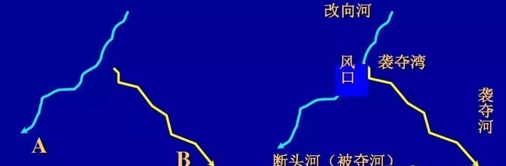
[River Raid]: Refers to the phenomenon that the river on one side of the watershed seizes the upper reaches of the river on the other side.

Causes: The causes of river raids are related to watershed migration and new tectonic movements.
【Watershed migration】When the slope and length of the two sides of the watershed are inconsistent, the speed of traceable erosion of the rivers on both sides is also different, and on the side with faster traceability erosion, the river source extends quickly to the watershed. When the water ridge is cut, the faster erosion of the river takes the upper source of the river on the other side, completing the process of river raiding.
[New Tectonic Movement] Sometimes a local new tectonic uplift occurs within a certain basin, and the river cannot maintain its original flow path, forcing the upper reaches of the river to flow into another river can also cause a raid phenomenon.
【Waterfall】: Waterfall is called falling water in geology, that is, the phenomenon of river water falling vertically from a high altitude when flowing through faults, depressions and other areas. During the period of the river's existence, the waterfall is a temporary feature that eventually disappears.
The cliff that causes the plunge will continue to collapse under the strong impact of the current, causing the waterfall to retreat upstream and lower its height, eventually causing the waterfall to disappear.
Eroded landforms of rivers
Erosion methods mainly include traceable erosion, under erosion and lateral erosion. Different sections of the river, the way the river is eroded is different, and the landform is different.
Initial: Traceable erosion and under erosion are the mainstays, forming a "V" shaped valley. It is found in the upper reaches of the river.
Medium term: erosion weakens, lateral erosion strengthens, and river valleys widen and bend, forming bends. It is generally located in the middle reaches.
The concave shore erodes and the convex shore accumulates.
Maturity period: the drop is very small, the lateral erosion is dominant, and the river valley is widened and appears in a wide and shallow groove. The underhoding stops and turns into sedimentation, usually downstream.
Accumulation of rivers
1. Alluvial fan (flood-alluvial plain): located at the mouth of the river, mostly distributed in arid and semi-arid areas.
The river flows out of the mountain pass, the terrain suddenly flattens, the river becomes wider, the water flow slows down, and a large amount of gravel and sediment carried by the river accumulates in front of the mountain, forming an alluvial fan (flood fan).
In arid and semi-arid areas, rock weathering is more pronounced, and there is a large amount of rock loose accumulation in mountainous areas, and when there is more precipitation in the mountains, it is more conducive to the formation of flood (alluvial) fans.
2. River floodplain plain:
In the middle and lower reaches of the river, the banks of the river accumulate, the accumulation continues to expand and emerge from the water during the dry season.
3. Estuary Delta:
When a river enters the sea or into the lake, if the underwater slope at the sea or lake is gentle, coupled with the support of the sea or the lake, the sediment will accumulate in front of the estuary.
Estuary three
Formation conditions of the cape:
1, the river carries a large amount of sediment. (Material conditions)
2. Sediment deposition. (1) The river power weakens and the flow rate slows down. Such as: the estuary terrain is low, the top of the tide, etc.; (2) The slope of the seabed at the mouth of the sea is gentle; (3) The tidal difference at the mouth of the sea is small, and the carrying capacity of the tide is weak. )
3. Internal force action (lifting and lowering of the earth's crust).
【Expansion】 Answering ideas for two types of landforms
2. Rivers are silted up
(1) The principle of river dredging
(1) Siltation principle: when the amount of sand coming from upstream is greater than the sand carrying capacity of the current section of the river, siltation is generated and the riverbed rises;
(2) Scouring principle: When the amount of sand coming upstream is less than the sand carrying capacity of the current section of the river, erosion occurs and the riverbed falls.
(3) Alternating principle: the same river section: the erosion and accumulation of the river is often "you are strong and I am weak", alternately; when the flow is large (flood season), erosion is mainly; the flow is small (dry period), mainly accumulation.
(2) The main erosion landforms and formation processes of rivers
(1) V-shaped valley (canyon): The earth's crust rises and is cut and eroded under the flowing water.
(2) Fjords: glacier erosion forms valleys; climate warms and glaciers retreat; seawater intrusion floods valleys to form fjords.
(3) Meandering stream (river bend) - generally found in grassland areas with flat terrain.
Formation process: gentle terrain, riverbed composed of loose sediment on the plain; slow flow rate, concave bank erosion, convex bank accumulation; grassland is luxuriant, grass root solidification is strong.
(4) Curved gorge: In the early ancient plains, the terrain was flat, the flow rate was slow, and the lateral erosion effect was strong, forming a curved current; later, the earth's crust was lifted, and the original meandering form was retained when the river was cut down.
(3) The formation process of flowing water accumulation landforms
1. requirements
(1) Accumulation: weathering or flowing water erosion → transport → accumulation (there is a difference in particle size).
(2) Slow flow rate: the terrain is gentle, the river is curved, and the seawater/lake/river water top support → the water flow speed is slowed down→ the carrying capacity is reduced.
(3) Sedimentary environment: space available for sedimentation, crustal uplift (descent), topographic conditions, water environment (waves, ocean currents) → sedimentary environment (sedimentary space).
(4) Regional differences: the differences in the sediment, the reasons for the slowing down of the flow rate, and the sedimentary environment in different locations, so there are differences in the location and form of the accumulation landform.
2. Common accumulation landform formation process: Take the estuarine delta landform as an example:
(1) Formation:
a. Sediment sources: the middle and upper reaches of sediment sources are abundant;
b. Location: At the mouth of the river (lake);
c. Reduced flow rate: flat terrain or sandbar diversion;
d. The speed of the water flow is slowed down; the sea water (lake water) is supported;
e. Sediment builds up; deltas form.
(2) Changes:
a. No delta formation: sediment, coastal topography, sedimentary environment (sedimentary space and seawater movement or crustal settlement).
b. Delta area increases or decreases: sources of sediment; sea level changes→ coastline changes (delta area increases, coastline advances, land area increases, sea level declines; delta area decreases, coastline retreats, seawater backfills, land area decreases, sea level rises).
c. Direction of delta extension: where the sea (ocean current) flows.
(4) Changes in flushing silt
1. Estuarine riverbed:
The combined influence of rivers and tides (waves), the strength of the two "one and the other"; during the flood season, the runoff from the upstream discharge washes the riverbed; during the dry period, the silt accumulation brought by the current and the waves (top support) is the mainstay; and it also causes changes in the coastline.
2. Estuarine seabed
During the flood season, when the flow of water is strong, there is more sediment flowing into the seabed, and the seabed is mainly silted; during the dry period, the flowing water is weak, and there is less sediment flowing into the seabed, and the seabed is mainly erosion.
【Consolidation and induction】
【Online Exercise】
(2019 · Jiangxi Xunwu Middle School February Examination) Located on the border of the United States and Canada, Niagara Falls attracts a large number of tourists every year. The waterfall is divided by Goat Island into two major waterfalls, Horseshoe Falls and American Falls, of which 94% of the water flows down Horseshoe Falls. In 1897, the world-famous "Niagara" hydroelectric station was built upstream of the beautiful Niagara Falls, and a large part of the water flow upstream of the waterfall was channeled into four large channels for use by downstream power plants.
Read the schematic diagram of the boundary change of Horseshoe Falls and answer the sub-question below.
1. Waterfall in the picture
A. The rewind speed is more uniform than that of B. Overall, it retreats southward
C. Retreated about 500 meters D. Retreat towards the lower reaches of the river
2. The main purpose of the construction of reinforcement and dredging areas is to build them
A. Prevent the inundation of small islands in the river B. Increase the viewpoint
C. Prevent the waterfall shoreline from receding D. Increase the runoff
3. The impact of the construction of the "Niagara" hydroelectric power station on Niagara Falls is
A. Increase the amount of water in the waterfall B. Increase the waterfall drop
C. Reduce the flow rate of the waterfall D. Increase the width of the waterfall
【Answer】1. B 2. C 3. C
【Analysis】
1. From the waterfall boundaries in different years in the figure, it can be seen that the waterfall retreat speed is not uniform, A is wrong; according to the relationship between the waterfall and the river learned, the waterfall should be retreating towards the upstream direction of the river, D is wrong; according to the distribution of the waterfall boundaries in different years in the figure and the distribution of longitude and latitude in the figure, the waterfall as a whole retreats to the south, B pair; the earth's surface latitude difference is 1 degree, the field distance difference is about 111 kilometers, and the difference between the two latitude lines in the figure is 18", The distance difference is about 33.3 kilometers, and it is estimated that the waterfall is roughly 26.3 kilometers backwards, C is wrong. Hence B.
2. It can be seen from the material that a large amount of water in the Niagara River fell after the Horseshoe Falls, strongly impacting the soft rocks in the lower part of the cliff, causing the rocks to gradually collapse and the Horseshoe Falls to retreat. As can be seen from the figure, the shoreline retreat speed near the reinforcement area and the dredging area is significantly smaller than that of other areas, mainly because the reinforcement measures have been implemented on both sides of the shoreline, and the river has been dredged at the same time, so that the river water has a strong ability to pass, the erosion force of the rock in the vertical direction is weakened, and the retreat speed of the waterfall is effectively controlled. Hence the choice of C.
3. From the material "a large part of the water flow upstream of the waterfall is introduced into four large channels for use by downstream power plants", it can be seen that the construction of the "Niagara" hydropower station will reduce the amount of water in the waterfall, A fault; the main factor affecting the waterfall drop is the terrain, which has nothing to do with the construction of the upstream hydropower station, B fault; because the drop is unchanged, the water volume is reduced, the flow rate of Nicaragua Falls is reduced, C is right; because the water volume is reduced, the width of the waterfall may be reduced, D is wrong. Hence the choice of C.
(2019 Shandong Gaokao Simulation) In the process of development of the two adjacent rivers, due to the strong erosion of the low-level river, the source is constantly extended, and the phenomenon of seizing its river water after meeting with the high-level river is called river raiding. After the seizure, some sections of the river may reverse the river and develop into a "reverse river". The following figure shows a topographic map of the contour line in a certain area of Shandong Province, showing that there has been a historical phenomenon of raids and seizures between the Zhou River and the Yi River in the Middle East.
Complete the following questions accordingly.
4. The following statement is correct
A. The Flow of the Eastern Zhou River is large, and it attacks the Yi River B. The Yi River is high in terrain and attacks the Eastern Zhou River
C. The East Zhou River erodes to the source and attacks the Yi River D. The Yi River fell at a large distance and attacked the Eastern Zhou River
5. The "reverse" section of the river in the figure is
A.BC段 B.CD 段C.CE段D.FG段
6. The characteristics of each river section in the figure are correct
A. The FG section forms a canyon and a waterfall B. There is a large amount of alluvial gravel in the EF segment
C. The east bank of the CE section first accumulated and then eroded D. The broad river valley in the CD section is narrowed
【Answer】4. C 5. C 6. B
4. The source of a river is constantly extended, and the phenomenon of seizing its water after encountering a high river is called river raiding. According to the contour value, at the C point, the altitude of the East Zhou River is less than 350 meters, the altitude of the Yi River is greater than 350 meters, the East Zhou River erodes to the source, attacking the Yi River, C is right, B, D is wrong. The size of the amount of water in the Eastern Zhou River is not the reason for the attack on the Yi River, A mistake.
5. The Yi River originally flowed northeast, and after being attacked, the "reverse" section of the river in the figure is the CE section, flowing to the southwest, C pair. The flow direction of the BC segment, CD segment and FG segment is unchanged, and A, B, and D are wrong.
6. The characteristics of each river section in the figure, the flow direction of the FG section is unchanged, the amount of water is reduced, and A is wrong. The EF segment is cut off, there is a large amount of alluvial gravel, B is correct. The east bank of the CE section eroded first and then accumulated, C error. The wide water in the CD section of the river valley becomes larger, and the D is wrong.
Figure 1 shows a schematic diagram of the relationship between landslides and geomorphological evolution in a certain area. Read the picture to complete 7 to 8 questions.
7. Infer the sliding direction of the landslide body in the plot
A. From North to South B. From west to east C. From northwest to southeast D. From northeast to southwest
8. The sequence of geographical events shown in the figure is the order in which they are formed
A.(2)(3)(4)(1)B.(2)(1)(3)(4)C.(3)(1)(4)(2)D.(3)(2)(1)(4)
【Answer】7. C 8. D
【Analysis】7. According to the morphology of the landslide boundary in the figure, the relative position relationship between the ancient river channel and the current river, combined with the relevant information such as the river terrace buried by the landslide and the location of the ancient weir lake, it can be inferred that the landslide body in the area slides from northwest to southeast (note the direction indicator in the figure), blocking the ancient river channel to form the ancient weir lake, and then the dammed body collapses to form a new river channel. Hence the choice of C.
8. According to the analysis of the above question, the landslide body in the area slides from northwest to southeast, and the landslide body buries part of the river terrace, at the same time, the landslide body blocks the ancient river channel, forming the ancient barrage lake, and then the weir body collapses to form a new river channel, so the sequence number shown in the figure is (3)(2)(1)(4). Hence the choice of D.
(Quality inspection and testing in June of the third year of high school in Sanming City, Fujian Province) The Liaohe River Delta is formed by sediment deposition of the Liaohe River, the Daliao River and the Daling River. Since the late Pleistocene, the Liaohe Delta has undergone a sedimentary evolution process of river channel (limnal swamp) - coastal (estuary bay) - shallow sea - delta. Read the Liaohe Delta area map (below) and complete the following sub-questions.
9. During the stage of sedimentary evolution from river channels (limnal marshes) to shallow seas, the overall process of change in the coastline of this region is
A. Move north first and then south to B. Move south first and then north
C. Move north to D. Move south
10. During the development period of the Liaohe Delta, the main factors leading to sea retreat were
(1) Sea level rise (2) The rate of sediment deposition is accelerating
(3) Sea level decline (4) Frequent changes in the earth's crust
A.(1)(2)B.(2)(3)C.(3)(4)D.(1)(4)
11. At the time of the largest transgression since the Late Pleistocene, the inference about rivers was reasonable
A. The number of rivers entering the sea is the largest B. The river has the greatest flow
C. The maximum sediment content of the river is D. The river flows for the longest
【Answer】9. C 10. B 11. A
【Analysis】9. From the stage of river channel (limnology) to shallow sea sedimentary evolution, the area has experienced the process of channel (limnal) - coastal (estuary bay) - shallow sea, indicating that the coastline is constantly retreating, combined with the largest sea intrusion range since the late Late Pleistocene in the map, it can be seen that the overall coastline has shifted northward, so C is chosen.
10. When the sea level rises, there will be no sea retreat, (1) error; sediment deposition rate increases, there is sea retreat, (2) correct; sea level decline, there is sea retreat, (3) correct; frequent changes in the earth's crust will lead to irregular fluctuations in the coast, (4) error; so B is chosen.
11. As can be seen from the figure, when the largest transgression since the late Pleistocene, the number of rivers entering the sea is the largest, A is correct; since the late Pleistocene, the flow of the river is not the largest, and the sediment content of the river is not the largest. Hence the choice of A.