Can see the mountains and lakes with a radius of more than 100 kilometers, after synthesis, it is a veritable "treasure map", with the three major capabilities of "wide vision, perspective and night vision"... At noon on December 26, China successfully launched the Resource No. 1 02E satellite (also known as the 5-meter optical satellite 02 satellite) with the Long March 4 Cyao 39 carrier rocket at the Taiyuan Satellite Launch Center, which will further promote the systematic application of China's land resources survey and monitoring satellite business.
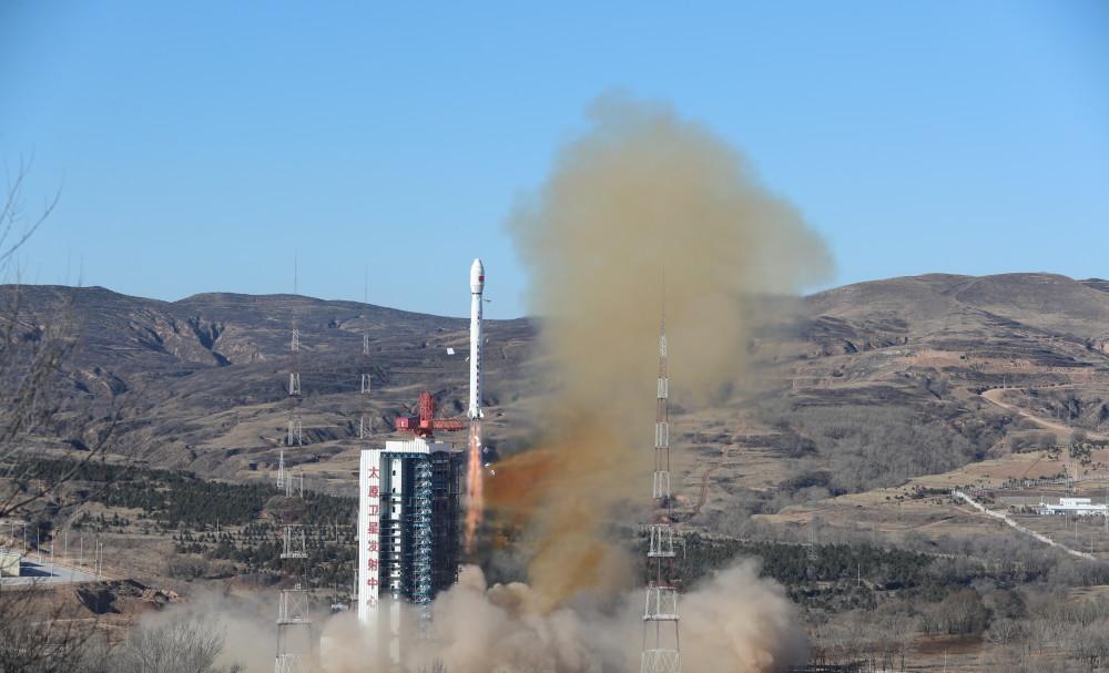
At 11:11 on December 26, China successfully launched the Resource No. 1 02E satellite with the Long March 4 C carrier rocket at the Taiyuan Satellite Launch Center. The satellite successfully entered the predetermined orbit and the launch mission was a complete success. Xinhua News Agency (Photo by Zheng Bin)
According to information released by the China National Space Administration, the Resource-1 02E satellite is a business star in the "National Civil Space Infrastructure Medium- and Long-term Development Plan (2015-2025)", operating in a sun-synchronous orbit, with the main payloads of visible near-infrared cameras, hyperspectral cameras and infrared cameras. The satellite launch quality is about 2500 kg, and in orbit can obtain image data better than 5 meters panchromatic, 10 meters multispectral and 30 meters hyperspectral image data, forming a remote sensing observation capability of terrestrial resources with medium spatial resolution, hyperspectral resolution and high temporal resolution.
After the satellite is put into use, it will be networked with the previously launched satellites, and the revisit time of the visible near-infrared camera land area will be increased from 3 days to 2 days, effectively improving the observation timeliness, achieving efficient global observation, meeting the needs of medium-resolution remote sensing data in China's natural resources monitoring and survey, geological and mineral surveying, geological environment monitoring and other businesses at this stage, and serving disaster reduction, environmental protection, housing, transportation, agriculture, forestry, marine, surveying and mapping and other industries.
According to experts from the Fifth Academy of Aerospace Science and Technology Group, the general development unit of the Resource No. 1 satellite, the 02E satellite is the ninth satellite in the Series of Resources No. 1, which will carry out natural resource monitoring tasks and continue to provide panchromatic, multispectral, and hyperspectral satellite images.
The infrared camera and visible near-infrared camera developed by the Fifth Academy of Aerospace Science and Technology Group 508 are the main payloads of the 02E star. It is reported that the visible near-infrared camera configured by the star has been optimized and upgraded on the basis of the 02D star, which can identify the near-infrared wavelength between visible light and infrared, and distinguish the shape, scale size and part of the color of the monitoring target. In addition, this "eye" will automatically adjust the optimal imaging line of sight, and see the mountains and lakes with a radius of more than 100 kilometers.

Schematic diagram of the Resource 1 02E satellite. Provided by the Fifth Academy of Aerospace Science and Technology Group
Considering the monitoring needs of minerals and mining areas, the 02E star uses a hyperspectral camera with 166 spectral bands, which has the ability to identify and classify features. The camera can fully cover visible light, near infrared and infrared, and subdivided into 166 spectral channels, a shot can obtain 166 photos of different spectrum segments, accurately capture the light information reflected by various types of features, through inversion calculations to calculate the content and coverage of the monitoring target, after synthesis is a veritable "treasure map".
In addition, the 3 cameras equipped with the 02E star give it the three major capabilities of "wide vision, perspective, and night vision". The satellite adopts a three-axis stable control mode of ground orientation, has the ability to yaw calibration, greatly improves the attitude maneuverability, and can quickly adjust the attitude for emergency monitoring needs, aiming at the target "raise the camera, say shoot and shoot".
The launch also carried a small satellite of 101 Middle School Science Popularization, and the user was Beijing 101 Middle School. The satellite is equipped with small imaging cameras, intelligent processing equipment, semiconductor thermoelectric power generation experimental equipment and other loads, and will carry out auxiliary geography teaching, science and technology experiments and other science popularization activities for middle school students after being put into use.
The Long March 4 C carrier rocket performing this mission is a normal temperature liquid three-stage carrier rocket developed by the Eighth Academy of Aerospace Science and Technology Group, for different types of satellites, the Long March 4 rocket can adopt a flexible launch program, with the ability to launch a variety of types and different orbital requirements of the satellite, can implement an arrow single star or multi-satellite launch, its sun-synchronous circular orbit carrying capacity of up to 3 tons (orbital altitude of 700 kilometers).
The mission is the final battle of the 2021 Long March 4 rocket, the 14th launch of this model this year, double the record number of launches in this model in the year, and setting a new high.
The China National Space Administration is responsible for the engineering organization and management of satellites, the China National Space Administration is responsible for earth observation and data center for the overall work of the project, the Ministry of Natural Resources is responsible for the construction and promotion of the application system as the leading user department, the satellite launch measurement and control system department is responsible for the implementation of the launch site and the measurement and control system, and the Resource Satellite Application Center and the Institute of Aerospace Information Innovation of the Chinese Academy of Sciences are responsible for the construction and operation of the ground system. (Reporter Hu Zhe)