Beijing News Express (reporter Zhang Jianlin) At 11:11 on December 26, China successfully launched a 5-meter optical 02 satellite with the Long March 4 C carrier rocket at the Taiyuan Satellite Launch Center, which will be networked with a 5-meter optical service satellite in orbit. It is understood that this mission is the 403rd launch of the Long March series of carrier rockets.
Achieve full coverage of hyperspectral data in the national land range for half a year
The 5-meter optical satellite 02 satellite is a business satellite in the National Civil Space Infrastructure Medium- and Long-term Development Plan (2015-2025), operating in a sun-synchronous orbit, with the main payloads of visible near-infrared cameras, hyperspectral cameras and infrared cameras. The satellite launch quality is about 2500 kg, and in orbit can obtain image data better than 5 meters panchromatic, 10 meters multispectral and 30 meters hyperspectral image data, forming a remote sensing observation capability of terrestrial resources with medium spatial resolution, hyperspectral resolution and high temporal resolution.
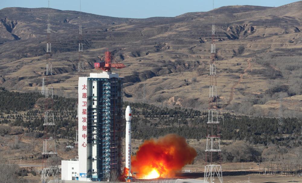
On December 26, China successfully launched a 5-meter optical 02 satellite with the Long March 4 C carrier rocket at the Taiyuan Satellite Launch Center. Photo courtesy of China National Space Administration (Photo by Zheng Fleeing)
After the satellite is put into use, it will be networked with a 5-meter optical satellite 01 satellite, which will increase the revisit time of the visible near-infrared camera land area from 3 days to 2 days, effectively improve the observation timeliness, achieve efficient global observation, meet the needs of Medium Resolution Remote Sensing Data for China's natural resources monitoring and survey, geological and mineral surveying, geological environment monitoring and other businesses at this stage, and serve disaster reduction, environmental protection, housing, transportation, agriculture, forestry, marine, surveying and mapping and other industries.
After the networking operation, it will form the world's leading business-oriented earth spectral detection capability, which can basically achieve half a year's full coverage of hyperspectral data in the national land range, and add another weapon to promote the transformation of Satellite Remote Sensing Monitoring of China's natural resources from quantity to quality ecology.
At present, the Ministry of Natural Resources has carried out large-scale application demonstrations in the fields of remote sensing survey of geology and mineral resources in the mineralization belt, soil organic matter content in northeast China, water quality monitoring of key inland lake reservoirs and vegetation growth monitoring in major ecological function areas, which has provided new important technical support for key work such as land quality monitoring and evaluation and ecological protection and restoration in China. The infrared camera on the satellite can be used to comprehensive remote sensing monitoring and evaluation of the production capacity of high-energy-consuming enterprises such as steel and coal, and provide data support for national industry supervision.
This launch carries the "101 Middle School" science popularization small satellite
The reporter learned that this launch also carries a "101 Middle School" science popularization small satellite, the user is Beijing 101 Middle School. The satellite is equipped with small imaging cameras, intelligent processing equipment, semiconductor temperature difference power generation experimental equipment and other loads, and will carry out auxiliary geography teaching, science and technology experiments and other secondary school students' science popularization activities after being put into use, as an important part of the China-Africa "Hope" science popularization cooperation plan, it will help build a space exchange platform for Chinese and African middle school students, and explore a new model of China-Africa space cooperation in science education.

On December 26, the 5-meter optical 02 satellite was successfully launched. Photo courtesy of China National Space Administration (Photo by Zheng Fleeing)
The 5-meter optical 02 satellite is a hyperspectral service satellite planned and deployed by the National Civil Space Infrastructure, with the Ministry of Natural Resources as the lead user, the Land Satellite Remote Sensing Application Center of the Ministry of Natural Resources as the project legal person directly responsible for the project construction management, and the China Academy of Space Technology and the Shanghai Academy of Aerospace Technology respectively undertake the development of satellites and launch vehicles.
In the next step, the Land Satellite Remote Sensing Application Center of the Ministry of Natural Resources will do a 5-meter optical 02 satellite in orbit test with relevant units. At the same time, based on the satellite application technology system of the ministry and province in the field of natural resources, accelerate the promotion of new payload data and application technologies such as hyperspectral, further improve the quantitative survey and monitoring capabilities of natural resources, timely control the quantity, quality, ecological status and change trend of natural resources, and provide data guarantee for the management and ecological supervision of Natural Resources assets in China.
Beijing News reporter Zhang Jianlin
Edited by Zhang Lei, Proofreader Zhao Lin