Look at the huge granite eagle from a distance, which is amazing, and the route from eagle's beak cliff through Bald Mountain is raiders
author:He Fat Fat Hike
Look at the huge granite eagle from a distance, which is amazing, and the route from eagle's beak cliff through Bald Mountain is raiders
[One mountain per week], today we walk: Fenghuanggou - Eagle's Mouth Cliff - Bald Mountain - Toad Ditch in Fengyuli, this route is 23 kilometers, with a cumulative elevation of 1300 meters, Eagle's Mouth Cliff is 2700 meters above sea level, and Bald Mountain is 2886 meters above sea level. There are dangerous peaks, beautiful views, and it is worth visiting.
Eagle's Mouth Cliff, also known as Phoenix's Mouth, is named after a huge granite rock standing at the top of the mountain, which looks like an eagle with its head held high. It is located on the back of the Qinling Ridge, which crosses the north and south, with babbling streams, primitive trees, and majestic peaks, facing the Bald Head Mountain.
Bald Head Mountain, located in Fengyu, is known as Bald Head Mountain because there is grass and no trees at the top of the mountain, and it looks bare from a distance. At the top of the mountain, there are Shaanxi Radio and Television Transmission Tower, open alpine meadows, spectacular sea of clouds, net red stones, rhododendrons, etc., which can overlook the Taibai Mountain, ice crystal top, deer antler beam, etc., which is a famous net red mountain in Shaanxi.
Look at the huge granite eagle from a distance, which is amazing, and the route from eagle's beak cliff through Bald Mountain is raiders
Navigate to Eagle's Mouth Cliff Homestay on a map, and the car is parked in the courtyard of the farmhouse. Then walk 50 meters back (north) to reach the trailhead.
Look at the huge granite eagle from a distance, which is amazing, and the route from eagle's beak cliff through Bald Mountain is raiders
The owner of the B&B is nice
Look at the huge granite eagle from a distance, which is amazing, and the route from eagle's beak cliff through Bald Mountain is raiders
The road ahead is easy to walk, there are also signs, 1.5 km fork left turn, 2.3 km there is a rest point, after the break point began to rise.
Look at the huge granite eagle from a distance, which is amazing, and the route from eagle's beak cliff through Bald Mountain is raiders
Look at the huge granite eagle from a distance, which is amazing, and the route from eagle's beak cliff through Bald Mountain is raiders
Look at the huge granite eagle from a distance, which is amazing, and the route from eagle's beak cliff through Bald Mountain is raiders
Look at the huge granite eagle from a distance, which is amazing, and the route from eagle's beak cliff through Bald Mountain is raiders
Look at the huge granite eagle from a distance, which is amazing, and the route from eagle's beak cliff through Bald Mountain is raiders
Take a break
At 2.7 km, cross the creek and start walking the first steep stone slope, about 300 meters. Then, slowly and continuously uplift along the dirt road.
Look at the huge granite eagle from a distance, which is amazing, and the route from eagle's beak cliff through Bald Mountain is raiders
Cross the creek
Look at the huge granite eagle from a distance, which is amazing, and the route from eagle's beak cliff through Bald Mountain is raiders
Look at the huge granite eagle from a distance, which is amazing, and the route from eagle's beak cliff through Bald Mountain is raiders
Look at the huge granite eagle from a distance, which is amazing, and the route from eagle's beak cliff through Bald Mountain is raiders
At 6 kilometers, you will reach the stone wall of Eagle's Mouth Cliff. 6.3 km, go up to yakou into the jianzhu forest, turn right along the road signs, and follow the stone wall.
Look at the huge granite eagle from a distance, which is amazing, and the route from eagle's beak cliff through Bald Mountain is raiders
Look at the huge granite eagle from a distance, which is amazing, and the route from eagle's beak cliff through Bald Mountain is raiders
Climb the second section of the very steep and slippery stone slope and soon come to the pass on the beam (7.3 km), which is a T-shaped fork in the road, turn left to bald mountain, turn right to eagle's mouth cliff. Let's go up Eagle's Mouth Cliff first, then Bald Mountain.
Look at the huge granite eagle from a distance, which is amazing, and the route from eagle's beak cliff through Bald Mountain is raiders
Look at the huge granite eagle from a distance, which is amazing, and the route from eagle's beak cliff through Bald Mountain is raiders
At 8 kilometers, climb the Eagle's Beak Cliff, which is more dangerous, but can look around the mountains. The southern beams stretch out to Bald Mountain.
Look at the huge granite eagle from a distance, which is amazing, and the route from eagle's beak cliff through Bald Mountain is raiders
Eagle's Mouth Cliff Top
Look at the huge granite eagle from a distance, which is amazing, and the route from eagle's beak cliff through Bald Mountain is raiders
Look at the huge granite eagle from a distance, which is amazing, and the route from eagle's beak cliff through Bald Mountain is raiders
Look at the huge granite eagle from a distance, which is amazing, and the route from eagle's beak cliff through Bald Mountain is raiders
Eagle's Mouth Cliff Northwest
Look at the huge granite eagle from a distance, which is amazing, and the route from eagle's beak cliff through Bald Mountain is raiders
Look southwest at Bald Mountain
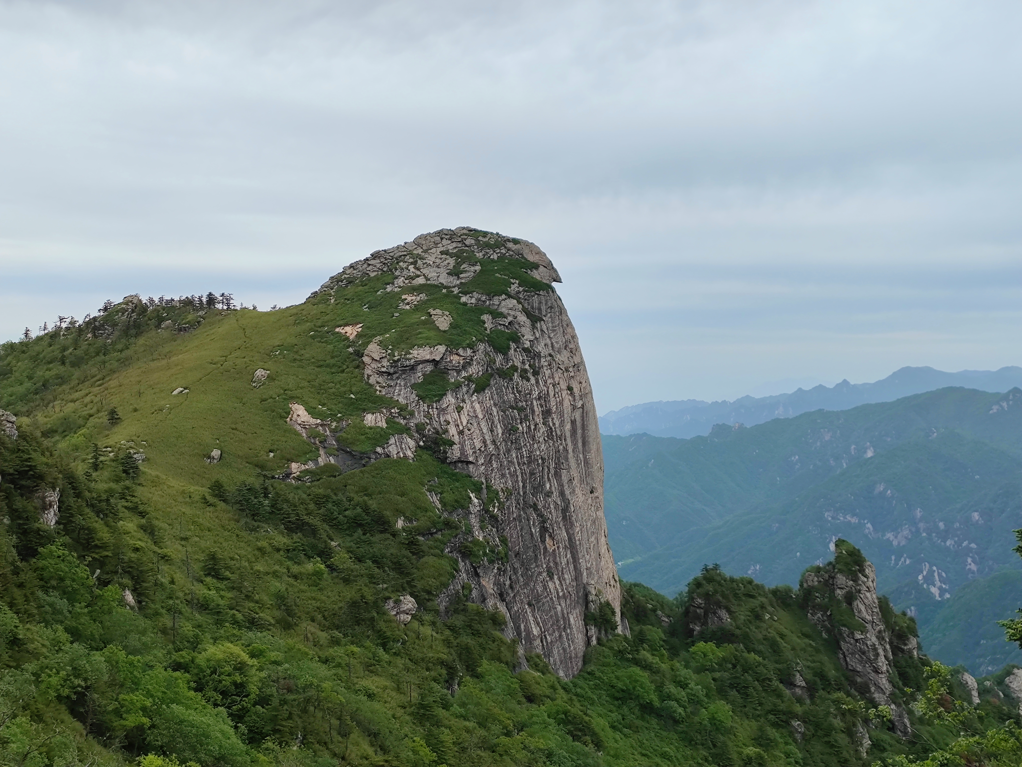
Descend from eagle's beak cliffs and continue through the dense forest of arrows and bamboo, passing a stone turtle. On the way, 10.7 km and 11.1 km, there is a viewpoint with excellent views and can look back at the whole of Eagle's Beak Cliff. When a complete, high-headed eagle stands in front of us, we are amazed.
Look at the huge granite eagle from a distance, which is amazing, and the route from eagle's beak cliff through Bald Mountain is raiders
Jianzhu was one person tall, heading towards Bald Mountain
Look at the huge granite eagle from a distance, which is amazing, and the route from eagle's beak cliff through Bald Mountain is raiders
Stone turtles
Look at the huge granite eagle from a distance, which is amazing, and the route from eagle's beak cliff through Bald Mountain is raiders
10.7 viewpoints
Look at the huge granite eagle from a distance, which is amazing, and the route from eagle's beak cliff through Bald Mountain is raiders
11.1 Viewpoints
The Jianzhu forest is intermittent, with a total of 3.5 kilometers to walk. After 13 kilometers, cross the small lawn and come to a fork in the road, the left side is to retreat (no need to go to the top), and the right side to climb the bald head mountain, where you can already see the red house at the top of the mountain.
Look at the huge granite eagle from a distance, which is amazing, and the route from eagle's beak cliff through Bald Mountain is raiders
After 15 kilometers, climb Bald Mountain overlooking The Eagle's Beak Cliff, purple bush cuckoos and sporadic hedgehogs. We chose to go down the mountain from Toad Gully today, and if we have enough time, we can also take the forest road and descend the mountain from the watershed. Of course, you can also pass through Bald Mountain to Staghorn Beam or The Great Temple. (Due to the arrival of twilight at this time, the photo is relatively dim)
Look at the huge granite eagle from a distance, which is amazing, and the route from eagle's beak cliff through Bald Mountain is raiders
Eagle's Mouth Cliff opposite
Look at the huge granite eagle from a distance, which is amazing, and the route from eagle's beak cliff through Bald Mountain is raiders
That net red stone
Look at the huge granite eagle from a distance, which is amazing, and the route from eagle's beak cliff through Bald Mountain is raiders
Look at the huge granite eagle from a distance, which is amazing, and the route from eagle's beak cliff through Bald Mountain is raiders
Look at the huge granite eagle from a distance, which is amazing, and the route from eagle's beak cliff through Bald Mountain is raiders
The road to Xia Bald Head Mountain is 7 kilometers, very easy to walk, from the red house, along the black cable, even the bungee jump less than 2 hours down to the 210 National Highway Xiawang Farm.
This route, in addition to the two stone steep slopes on the Eagle's Mouth Cliff is a little more difficult, the overall is quite good, and the beautiful scenery of the dangerous peaks on this route is indeed nostalgic.
Tip: When traveling and climbing, be sure to pay attention to the weather and travel together.
Recently, the staff of the Guantoushan Provincial Nature Reserve Management Bureau in Shanxi Province, when the system processed the continuous monitoring results of the identification infrared camera, found that an infrared camera captured the world's rare birds brown...