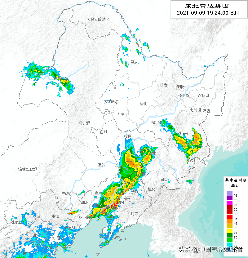
On the evening of September 9, from the northeast radar puzzle, tonight China's northeast region has a vigorous development of radar echoes, especially from the south-central part of Liaoning to the central part of Jilin a dense radar echo belt is particularly conspicuous, the radar echo in some areas also shows a deep red, which not only means that rainfall is developing rapidly in the northeast region of China, but also the rainfall cloud system in some areas has also developed extremely strongly, in addition to rainfall, some areas have encountered fierce thunderstorms, strong winds, hail and other strong convective weather attacks!
For example, this afternoon, from the monitoring data, today in many parts of northern China, there are generally 6-7 gales (blue areas), and the wind in some areas has reached 8-9 (yellow area), and there are also strong winds in the southern part of the northeast plain of China, which is the characteristic of strong convection.

According to many northeastern netizens, this afternoon Liaoning, Jilin and other places encountered sudden changes in wind and clouds, lightning and thunder, wind and rain, heavy rain pouring, and even once day turned into night, and some areas also encountered hail weather. The video taken by netizens shows that in Jilin Jianzhu University, Jilin Jianzhu University was damaged in a foreign wall glass on campus in a storm, and the glass slag was scattered on the ground, and some netizens said that it felt like a "typhoon", Changchun Rail Transit Group Company released a message, and the first section of Rail Transit Line 3 was suspended.
Then some netizens will ask, why is the weather in the northeast suddenly so grumpy, is this typhoon Candu landed? Of course, this is not a typhoon landing, typhoon Candu this afternoon is actually still in the western Pacific Ocean east of the Philippines, "108,000 miles" from the northeast of China, it is completely impossible to hit the eight rods. The system that leads to fierce weather such as thunderstorms and strong winds in the northeast of China is the cold vortex system that comes to the northern region of our country today, and from the satellite cloud map in the afternoon, this powerful cold vortex is circling in the northeast region of China, and it is constantly throwing out the cold air mass south to the northeast, stimulating thunderstorm weather.
But the cold air mass is not enough, in September this year, the warm air in many parts of the northeast is actually still very active, cold and warm battle makes the strong convective weather become extremely fierce, so that this thunderstorm has a dangerous and destructive force. Generally speaking, the warm air in the northeast in September in previous years is not so strong, and this year's fierce thunderstorms may be the product of the northward shift of the climate zone, which may well indicate an abnormal climate pattern this autumn.