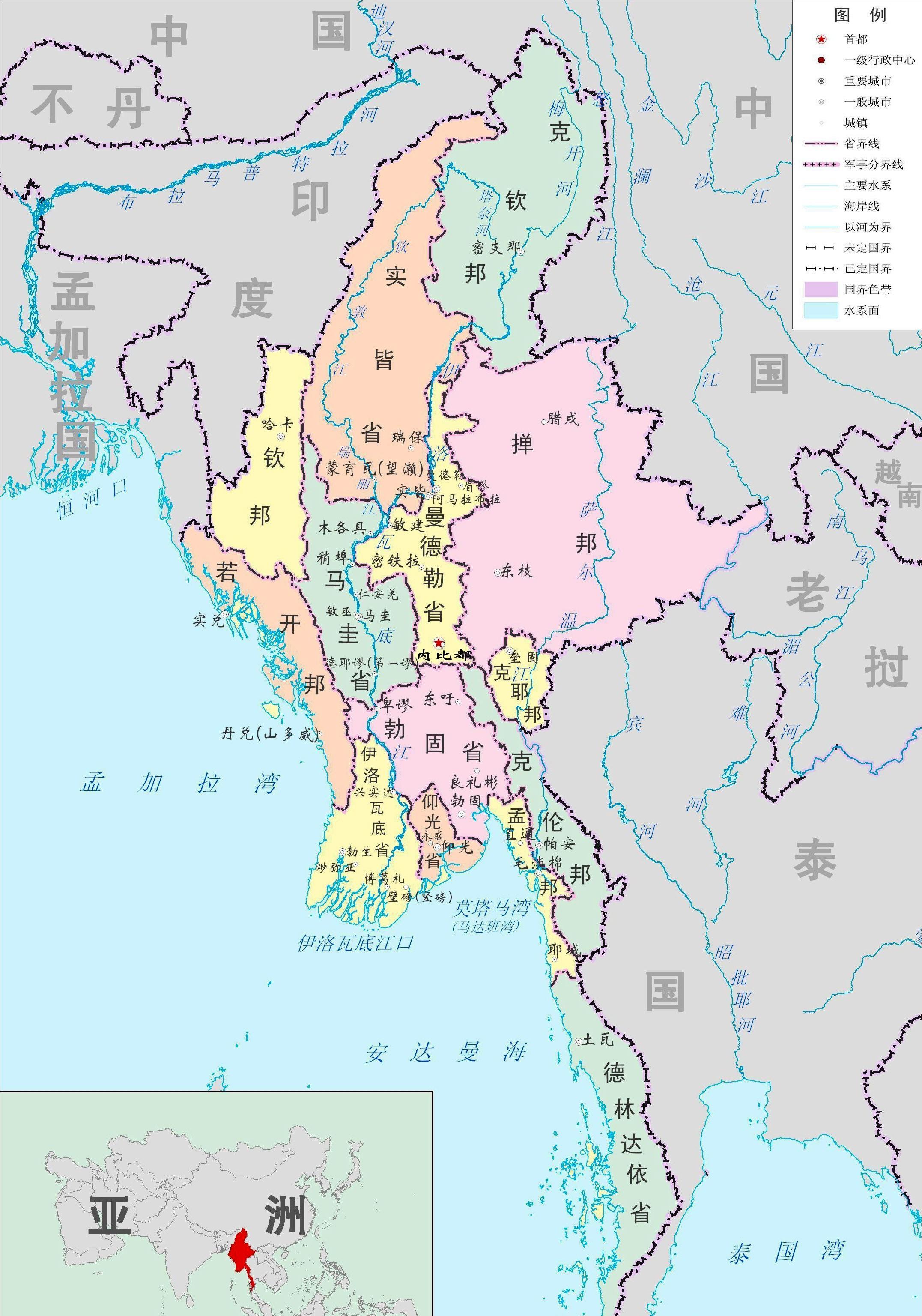
The Republic of the Union of Myanmar, or Myanmar for short, is a country in Southeast Asia and a member of the Association of Southeast Asian Nations. Bordered by the Andaman Sea to the southwest, India and Bangladesh to the northwest, China to the northeast, Thailand and Laos to the southeast, and Naypyidaw as its capital, with a land area of 677,000 square kilometers and a population of 54.58 million (April 2020 data).
Excellent natural geographical conditions
Myanmar's terrain is high in the north and low in the south, surrounded by mountains in the north, west and east, and faces the Indian Ocean like a "dustpan".

The topographic structure of Myanmar is also horseshoe-shaped, with high mountains and plateaus in the east, north and west, alluvial plains in the middle, and the Indian Ocean in the south, and the whole of Myanmar from north to south.
There are three main parallel mountain ranges in central Myanmar, running in a north-south direction, from east to west, the Rakhine Mountains, the Bago Mountains and the Shan Plateau, and these three mountains also divide the whole of Myanmar into three river systems, namely the Irrawaddy River, the Sidang River and the Salween River, which flow into the sea from north to south.
Northern
The northern part of Myanmar is a high mountainous area, which belongs to the continuation of the Hengduan Mountain Range in the Yunchuan-Tibet region of the mainland in northern Myanmar, mostly in a north-south direction, and the altitude of the mountains is mostly 4000-5000 meters.
Some of the peaks in the north of Myanmar are covered with ice and snow all year round, and among the ASEAN countries, only Myanmar has a snow-capped mountain with perennial ice.
Most of Myanmar's rivers originate or flow through it, including myanmar's two major rivers, the Irrawaddy River (the largest river in Myanmar, the east source - the Nmeikai River, originating in the southern foothills of the Bersula Mountains in Yunnan, the western source; the West-source Mai LiKai River originates in the Kumenling Mountains of northern Myanmar) and the Salween River (the second largest river in Myanmar, called the Nu River in the mainland, originating in the Tanggula Mountains in the central part of the Qinghai-Tibet Plateau in the Tibet Autonomous Region).
The highest peak in Myanmar is the Khy kabo Peak (belonging to the Hengduan Mountain Range) near the mainland border, at an altitude of 5881 meters, and the Enmeikai River, the east source of the Irrawaddy River, the largest river in Myanmar, winds around the peak. Here it mainly includes several north-south mountain ranges such as Kumen Ridge and Gaoligong Mountain.
westward
The western part of Myanmar is a longitudinal mountain range and hills in a roughly north-south direction, from north to south mainly includes Mount Patek, Naga Hills, Longalang Mountain and Rakhine Mountains, which is also roughly the natural border between Myanmar and India, which separates the two countries, and can also be approximately said to be the dividing line between Southeast Asia and South Asia.
Most of the mountains and hills in western Myanmar are between 2000 and 3500 meters above sea level, and only a few peaks exceed 3500 meters, such as Saramaty Peak (3840 meters) and Victoria Mountain (3658 meters) on the Indo-Myanmar border. This effectively resists the spread of high pressure zones formed near the equator from India to the east, and also reduces the chance of summer flooding. Note: Myanmar's horseshoe-shaped terrain allows Myanmar to adequately retain water vapor.
This is mainly due to the mountain belt formed by the direct extrusion of the northeast side of the Indian Ocean Plate and the southwest side of the Eurasian Plate (the red circle area in the figure below), coupled with the mutual squeezing of the Pacific Plate, forming the Shan Plateau in eastern Myanmar.
eastern
The eastern part of Myanmar is the Shan Plateau, with an average altitude of 1500-2000 meters, bounded by Mount Laibetsu, Bennong Mountain and Myanmar's second largest city , Mandalay in the west, and the mountains of China, Laos, Thailand and other countries in the east, covering an area of about 170,000 square kilometers.
The terrain of the Shan Plateau is undulating, with rivers running through and dividing each other, forming many folded mountains and deep valleys, ridges and ravines crisscrossing each other.
The plateau is covered with karst landforms, but the ground erosion is intense.
The Kokang region as we know it is located on the northern shan plateau bordering the mainland.
Southern
Myanmar is bordered by the Bay of Bengal to the southwest, the Andaman Sea to the south, and the Andaman Islands of India across the Koko Strait (both of which belong to the Indian Ocean).
It is bordered by Thailand to the southeast and to the south to the Malay Peninsula near the Kra Isthmus (the narrowest part of the northern Part of the Malay Peninsula, only 56 km wide, where the Planned Isthmus Canal of Malaysia and Singapore does not have to cross the Strait of Malacca).
Myanmar's three special economic zones are located on the southern coast of Myanmar, namely the Kyaukphyu Special Economic Zone in Rakhine State, the Dilowa Special Economic Zone in the Ting Yin-Kyaukdan Township District of Yangon Province, and the Tuwa Special Economic Zone in Delintdayi Province.
The China-Myanmar oil and gas pipeline is the fourth largest energy import channel after the Central Asian oil and gas pipeline, the China-Russia crude oil pipeline and the sea channel. It includes crude oil pipelines and natural gas pipelines that allow oil and gas to pass through the Strait of Malacca from Made Island, a miniature island southeast of Kyaukpyu Port on Myanmar's west coast, to Kunming on the mainland, and then the crude oil pipeline north to Chongqing, once plagued by "oil shortages", and the natural gas pipeline south to Guangxi.
Central
Central Myanmar is home to the low-lying alluvial plains of rivers such as the Irrawaddy And Sidang Rivers, the relatively low Bago Mountains, and the Minkin Mountains and the Gan Mountains to the north.
The central plains of Myanmar have a tropical monsoon climate, with most of Myanmar located in the tropics south of the Tropic of Cancer, and only a small part of the region north of the Tropic of Cancer, in the subtropics.
The mountains and plateaus that surround the west, north and east of Myanmar are like barriers that block the cold air of the Asian continent in winter, while the southern part of Myanmar has no mountain range, and the warm and humid air flow from the Indian Ocean can be unimpeded.
Myanmar's temperature does not change much throughout the year, the average temperature in the coldest month (January) is 20-25 °C, the hottest month (between April and May) the average temperature is only 25-30 °C, there is no severe cold and heat throughout the year, and Myanmar has abundant rainfall, here the ecological environment is good, there are fewer natural disasters, and it is very suitable for the development of agriculture.
Myanmar has a total population of 54.58 million, of which the agricultural and pastoral population accounts for about 70% of the total population. Myanmar's main crops include conventional crops such as rice, wheat, corn, beans and industrial crops such as rubber, sugarcane, cotton, and palm.
Yangon, the former capital of Myanmar, is the largest city in Myanmar, located in an area of 598 square kilometers, with a population of 7.61 million, and was the capital of Myanmar from 1855 to 2005 (the capital was moved to Naypyidaw on November 6, 2005).
Naypyidaw, the capital of the Republic of the Union of Myanmar, is the third largest city in Myanmar (Mandalay, located in the inland of south-central Myanmar, is the second largest city in Myanmar), and is strategically important.
Resourceful
forest resources
The forest cover of Myanmar is about 41.3% (2019 data), and the forest is mainly distributed in the northern and western mountains of Myanmar and the Bago Mountains in the central part of Myanmar, which is one of the most forested countries in the world. Among them, the central Bago Mountains are the main production areas of teak, and the reserves are leading in the world.
mineral resources
The Shan State-Delinday Highlands in eastern Myanmar are concentrated with minerals such as lead, zinc, silver, tin, tungsten, antimony, precious stones and jade, and there are mainly copper, gold, oil, natural gas and coal mines in central Myanmar, and chromium and nickel in the Naga-Rakhine Mountains in western Myanmar.
However, due to Myanmar's lack of overall geological exploration capabilities, there is no precise statistical data on the reserves and distribution of mineral deposits, and there may be other unknown mineral deposits. Moreover, Myanmar's mining capacity is limited, the efficiency and cost of the mining process are slightly backward, and the environmental pollution is also large.
Myanmar's oil and gas resources are mainly distributed in the central and coastal regions of Myanmar, with about 160 million barrels of oil and 20.11 trillion cubic feet of natural gas, and Myanmar currently has the seventh most proven natural gas reserves in the Asia-Pacific region.
Myanmar's rubies are the finest in Asia and the world, i.e. "pigeon's blood red" grade, transparent, uniform in color with no or very few cracks and imperfections. Myanmar is therefore also known as the "Land of Rubies".
Hydraulic resources
Abundant rainfall and meltwater from the mountains have created a dense concentration of domestic rivers, the main rivers being the Irrawaddy, Salween, Chintun and Mekong rivers, with tributaries throughout the country. Among them, the Irrawaddy, Salween and Mekong rivers all originate in China.
Myanmar's dense network of rivers provides a great guarantee for Myanmar's agricultural production, where rivers converge to create large alluvial plains and deltas suitable for farming, where there are sufficient irrigation conditions, fertile land and sufficient heat.
Population of Myanmar
Myanmar has a population of about 54.58 million (as of April 2020), a population density of about 83.3 people/km2 (the mainland population density is about 8145 people/km2), more than 60% of the population is engaged in agriculture, Myanmar has a relatively even population living in the central plains, only a few large cities like Yangon, Naypyitaw, Myitkyina and other large cities have more people gathered.
Myanmar is also a multi-ethnic country with a total of 135 ethnic groups, of which the Burmese account for about 65% of the total population.
Why did Myanmar develop into a least developed country with such superior natural conditions?
Myanmar is known as the Asian road bridge, is the hub of connecting Southeast Asia, China's great southwest region, south Asian subcontinent, but also China's nearest external window to the Indian Ocean, it is no exaggeration to say that Myanmar's natural conditions are better than more than 90% of the world's countries, but now Myanmar's per capita GDP is only 1300 US dollars, by the United Nations as "the world's least developed countries" backward countries. So what is holding back Myanmar's development?
First, Myanmar is a multi-ethnic country with complex ethnic tensions that make it difficult for the country to focus on economic development.
Second, the flat terrain of central Myanmar is almost occupied by ethnic Burmese, while the border area of the plateau hills is a gathering area for ethnic minorities, and the uneven distribution of land among various ethnic groups has also led to the pursuit of independence in many border states of Myanmar, and frequent civil wars with government forces, which have greatly depleted Myanmar's national strength.
Third, as a third world country that has long suffered from British colonial rule, Myanmar lacks an advanced industrial base and is difficult to attract foreign capital due to domestic turmoil.
At present, Myanmar's biggest advantage is to be close to the powerful China, and Myanmar has a superior geographical location that is also of great help to China's development strategy, at present, Myanmar has joined the Belt and Road projects built by China, stepped up the construction of the China-Myanmar Economic Corridor, and vigorously radiated modern civilization to the border mountains of Myanmar, and vigorously safeguarded the peaceful development of the nation. Accelerating industrial construction, increasing jobs, and allowing factories to run to replace domestic contradictions, Myanmar has also successfully entered the fast lane of economic development in recent years.
PS: View the map to understand the world to bring you to re-understand a country I am @ map observer The content is for learning and exchange only
There are other additions to Myanmar's topography and the reasons for its backwardness, and everyone is welcome to leave a message in the comments section
Ask for attention, ask for forwarding
——END——