Map of Ayutthaya County
Dacheng County, Langfang City, Hebei Province
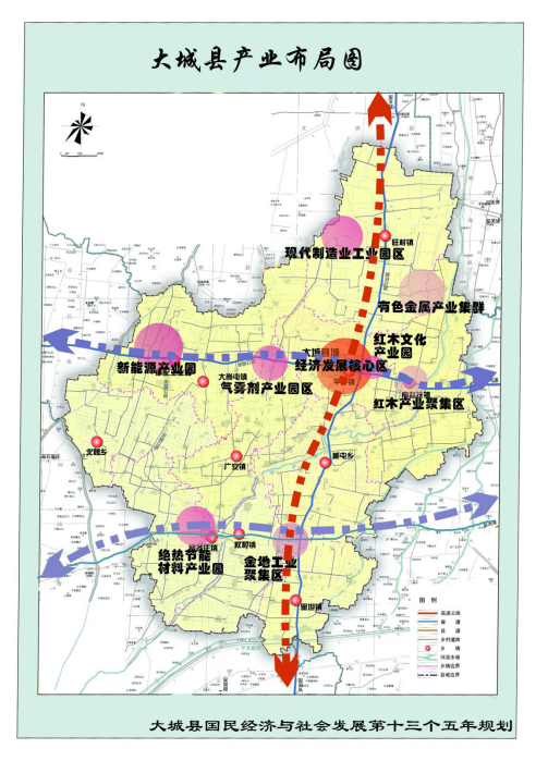
Industrial layout map of Ayutthaya County
The 13th Five-Year Plan for Dacheng County
Original 1.00 MB
Year 2018
Ayutthaya County
Spatial distribution structure of the county
One City:
The central urban area of the county
Two districts:
(1) The northern economic zone composed of South Zhaofu Town, Wangcun Town, Dashangtun Town and Modern Manufacturing Industrial Park.
(2) The southern economic zone consisting of Liugezhuang Town, Quancun Town, Guang'an Town and Litan Town.
One spindle:
Relying on the Langbo Highway, the main axis of spatial development connecting Wangcun Town, Central Urban Area, Liugezhuang Town, and Quancun Town from north to south.
Two secondary shafts:
First, relying on the Jinbao Highway, the east-west spatial development sub-axis connecting Dashangtun Town, the central urban area, and the south Zhaofu Town.
Second, relying on the Cailiu Highway, the sub-axis of spatial development connecting Dashangtun Town, Liugezhuang Town, and Quancun Town from north to south.
Spatial layout of urban and rural areas in Dacheng County
Original figure 2.09 MB

Map of Dacheng County, Wen'an County, Bazhou City
Bazhou City, Wen'an County, Dacheng County
Original figure 1.19 MB
Location of Ayutthaya County
Dacheng County → 140 km from Beijing
Dacheng County → Tianjin 70 km
Dacheng County → Shijiazhuang 204 km
Langfang Humanities Map
Year 2017
Anci District, Guangyang District, Gu'an County
Yongqing County Xianghe County, Dacheng County
Wen'an County, Bazhou City, Sanhe City
Dachang Hui Autonomous County
2017 Langfang Humanities Map