Older generations of Hong Kongers often talk about the terrible "three years and eight months" of the Second World War and the suffering of people during this period of Japanese unification. What Hong Kong experienced before the fall of hong Kong was an 18-day war, known in history as the "Hong Kong Defense War" (8-25 December 1941). Today, the newly developed "Interactive Map" by the research team of the History Department of Hong Kong Baptist University seeks to restore the truth of the battle.
"Hong Kong Defense War"
The Battle for Hong Kong was the most significant military event in Hong Kong in modern times, during which more than 2,000 soldiers and some 4,000 civilians were killed or wounded. Eighty years later, what happened during the war may be unimaginable and incomprehensible to many Hong Kongers today. For a generation that grew up in the digital world, traditional methods of teaching history tend to be tedious. How can we inspire and encourage them to understand a piece of history that is so important to Hong Kong? Dr. Kwong Chi Man, Associate Professor of the Department of History, answered this question with action...
"Hong Kong Defense War Theme Electronic Interactive Historical Map"
Dr. Kwong and his team have been studying the defense of Hong Kong since 2011 and have published books and papers in both English and Chinese, including Fortress of the East: A Military History of Hong Kong, which won the 2019 Hong Kong Book Award.
During the research process, Dr Kwong was granted by the Quality Education Fund to develop the "Electronic Interactive Historical Map on the Theme of the Defence of Hong Kong" that can be used as a teaching material for schools in Hong Kong. The purpose of the map is to stimulate students' interest in learning history and using the map, while strengthening the society's research and attention to history.

The picture shows Dr. Kwong and the Interactive Historical Map
Dr Kwong's team, assisted by HKBU Knowledge Transfer Office and HKBU Library Digital and Multimedia Services, spent two years collecting, researching and analyzing relevant first-hand historical materials. The Chinese and English versions of the map were made available online in August 2021, and a mobile version of the map for smart devices is already available. The team is currently designing instructional resources to train teachers to use maps with students in the classroom.
Visualize historical presentation
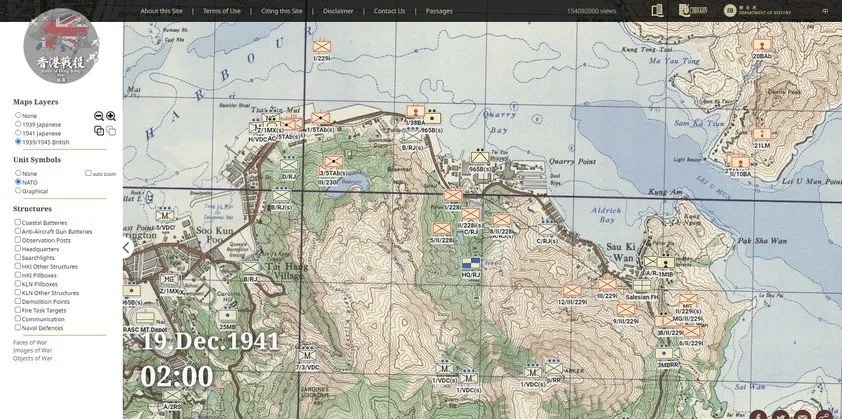
One of the features of the Interactive Historical Map is the innovative use of the Historical Geographic Information System (HGIS), which overlays the wartime maps used by the British and Japanese armies on Google Maps. Users can get a complete picture of the war on the map, viewing the distribution of the warring forces marked at different points in time, the location of relevant military locations, and the wartime people.
Visualize historical maps
The map tells the story from a first-person perspective, and by combining digital technology with historical content, viewers can freely interact with different categories of data, explore the timeline of the campaign, and experience historical events beyond the traditional text level.
The map shows data including military units, more than 300 wartime military buildings, real personal experiences of about 80 soldiers and civilians, descriptions of weapons, war crimes scenes, wartime photos, and photos taken by Dr. Kwong's team at historical sites.
The map collects first-hand information and evidence from multiple sources to recreate the defense of Hong Kong in a multimedia way
Dr Kwong's team includes Prof Wing Chung, Wong Man Kong, Dr Tak Wai And, Dr Tam Ka Chi, as well as three Hong Kong historians, Mr Tony Banham, Mr Choi Yiu Lun and Mr. Ott Kong. Through the data and materials displayed in visual form, they have created a new way of teaching history for Hong Kong students and the public, allowing users to immerse themselves in the historical world from an unprecedented spatial perspective and time dimension. In self-directed exploration and interaction, history education will become a pleasant and surprising experience.