Tan Qijun (1911–1992), a native of Jiashan, Zhejiang, was a famous Chinese historian and historical geographer. He has long been engaged in the teaching and research of Chinese history and Chinese historical geography, and has done a lot of research on China's historical territories, political regions, ethnic migrations and cultural regions. In 1954, New China wanted to produce a new set of historical atlases, and Tan Qihua became its editor-in-chief. This atlas is the Historical Atlas of China, which has been widely cited in middle school history textbooks and many history books, and seems to have become an authority. However, authority is not necessarily real or objective. Due to the influence of the environment of the times, Tan Qihua's "Historical Atlas of China" has many errors. Although Tan Qijun studied under Gu Jiegang, this atlas basically abandoned the style of Gu's atlas, but basically inherited the characteristics of "map opening up frontiers" in Guo Moruo's "Map of Chinese History Manuscript". In addition to "map opening up frontiers" and "map shrinking frontiers", different standards are also major problems in tan edition atlases. This article will roughly talk about the problems that occur in the Tan edition of the atlas.
First, the question of the transition from the Qin Dynasty to the Southern and Northern Dynasties
First of all, start with the Qin Dynasty. The territory of the Gu Dynasty of the Qin Dynasty was toe(northern Vietnam) and not yungui, because the Book of Han records that the Elephant County of the Qin Dynasty was set up in the area of Hanoi, Vietnam. The "Southwest Yi" in the Yungui region did not set up counties until the time of Emperor Wu of the Han Dynasty and included them in the territory. However, Tan Qijun, on the contrary, marked Xiang County in Pingxiang, Guangxi, and at the same time included Yelang and Dianguo into the territory of the Qin Dynasty. Here, the division of Yelang and the State of Dian into the territory of the Qin Dynasty is a map to open up the frontier, with the purpose of showing "since ancient times". The purpose of proposing the territory of the Qin Dynasty is to cater to the views of Vietnamese historians and express the relationship of "good neighborliness and friendship".
Tan version of the Qin Dynasty map
Then look at the territory of the Western Han Dynasty. On the entire map of the Western Han Dynasty, the map of the territory was drawn to the western region. In 60 BC, the Han Dynasty set up the Western Regions Capital Protectorate in the Western Regions, which was a military institution to control the countries and transportation routes in the Western Regions. Because of the military garrison, it can mean that the countries in the western region were included in the territory of the Han Dynasty.
However, the Western Regions Capital Protectorate could not control Wusun and Dawan. The Western Han Dynasty and Wusun were allies and marriages, and in the "Book of Han and the Tale of the Western Regions", Wusun was referred to as a "foreign country", and one of the purposes of the Western Regions Capital Protection was to prevent these foreign intrusions. As for Dawan, although Emperor Wu of Han once attacked Dawan, he still failed to control this place due to the inability to reach the whip. On the territory of the Eastern Han Dynasty, Tan Qijun was not included in Dawan and Wusun. In addition, Tan Qijun did not include Hainan in the territory of the Two Han Dynasties, but Emperor Wu of han set up counties in Hainan.

Territory of the Western Han Dynasty
Map of the Eastern Han Dynasty
During the Wei and Jin dynasties, the problem was here in the Western Regions ChangshiFu. During the Wei and Jin dynasties, the influence of the Central Plains on the Western Regions was greatly weakened and could not control the Western Regions. According to the Book of Jin, when Lü Guang conquered the Western Regions, "the princes descended to more than thirty kingdoms... The Verses of the Shanghan Dynasty". These western kingdoms brought the runes of the Han Dynasty, not the Wei and Jin dynasties, which shows that the Wei and Jin did not rule here. However, the territory of Wei and Jin extended to the Gaochang area in the eastern part of the Western Regions, where there were also Tuntian and Zhujun, and the Changshi Mansion of the Western Regions was located in the Gaochang area, where there were also excavated cultural relics.
Map of the Three Kingdoms
On the map of the Former Qin and Eastern Jin Dynasties, Tan Qijun did not include the Western Regions in the Territory of Former Qin, which was also wrong. Former Qin had already sent Lü Guang to the west to conquer the Western Regions, and had more than 30 countries in the Western Regions surrender and replace their runes, so the Western Regions should be included in the Territory of Former Qin.
Territory of the Former Qin and Eastern Jin Dynasties
By the time of the Southern and Northern Dynasties, the territory of the Southern and Northern Dynasties was not much of a problem, but Goguryeo was not colored. According to Tan Qijun's train of thought, the color on the map is the Chinese regime and the Chinese nation, and Tan Qijun regards Goguryeo as the regime of Korea, and there has been a serious mistake.
The early territory of the Southern and Northern Dynasties
Another thing to complain about is the northern boundary of the nomads. From the Han Dynasty to the Southern and Northern Dynasties, Tan Qihua drew an arc-shaped line from the Heilongjiang River to Lake Balkhash, which has not changed in 600 years, which is extremely abnormal.
Second, from the Sui Dynasty to the Song Dynasty
The sui dynasty was taken in 612. The Sui Dynasty defeated Tuguhun in 609 and set up the four counties of Xihai, Heyuan, Shanshan, and Zhimu, but the two counties of Xihai and Heyuan were all located in the homeland of Hehuang and did not penetrate deep into the interior of Qinghai. After the destruction of Tuguhun, the Sui Emperor sent Murong Shun as Tuguhun Khan, and before Murong Shun arrived, Tuguhun was restored and captured many cities in the Sui Dynasty. It can be seen that the Sui Dynasty did not completely eliminate Tuguhun and therefore could not penetrate deep into the interior of Qinghai. In addition, the Western Turks on the Sui Dynasty's map were incorrect, and the Western Turks controlled almost all of Central Asia, including north of Lake Balkhash.
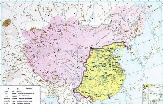
The territory of the Tang Dynasty is a representative work of Tan Qihua's "map to open up xinjiang". Tan Qijun's full map of the Tang Dynasty is three, in 669, 744 and 820. In 669, the Tang Dynasty had eliminated the Eastern Turks, Western Turks, Goryeo and Xueyantuo, and was the peak of the Tang Dynasty's territory. However, the Tang Dynasty never stationed troops in northern Mobei, and the so-called Protectorate of Anbei was only given the title of the leader of the Hui. In the Western Regions, Tan Qijun included the Sogdian states (Zhaowu Jiu surname), the 27 Kingdoms of Tocharians, and the corner of Persia into the territory of the Tang Dynasty, which was very absurd. These small states were at that time between the four major forces of Arabia, Tang Dynasty, Turks, and Tibet, wavering, and nominally accepted the canonization of various countries, which could not be counted as the land of the Tang Dynasty. During the reign of Emperor Gaozong of Tang, the westernmost military stronghold of the Tang Dynasty was the four towns of Anxi, and the Ili River Valley was still a Turkic sphere of influence.
The map of the Tang Dynasty in 744 included the entire northeast in the territory, which was also wrong. Because at that time, Tang Xuanzong only nominally sealed the three governors of Bohai, Murongwei, and Heishui, and did not really manage and send troops. In fact, the Tang Dynasty's sphere of influence had long since withdrawn from the northeast, and the Andong Capital Protectorate had also migrated to western Liaoning within 743. According to the History of Liao, the Liaodong region of the Tang Dynasty was occupied by the Bohai State. The Tang Dynasty lost Liaodong, so why manage the Heilongjiang area? In addition, in 743 the Tang Dynasty painted the westernmost painting to the west of TheRos, which is wrong. At that time, the area around Qiluo belonged to the Shi Kingdom and was one of the nine surnames of Zhaowu. Gao Xianzhi's policy in the Western Regions at that time led to the dissatisfaction of the Nine Surnames of Zhaowu, so Shi Guo and others had already surrendered to Arabia. The Battle of Qiluo was fought by Gao Xianzhi deep into the Arab sphere of influence, so it was not counted as the territory of the Tang Dynasty.
Territory of the Tang Dynasty in 744
The Tang Dynasty's territorial errors in 820 were even more pronounced. At that time, the "Anshi Rebellion" had already been experienced, and the Tang Dynasty could not even control the towns of Hebei Province. However, Tan Qijun still painted the vast land from the northeast to the Heilongjiang River Basin within the territory of the Tang Dynasty, and did not cover the bottom, which is very absurd. At that time, the most important regime in the northeast was the Bohai State, which not only annexed Liaodong during its power, but also defeated the Heishui Jingxiao, basically unifying the Jing region. The Tang Dynasty territory of 820 still marked the "Andong Capital Protectorate" in the Liaoyang area, which moved inland to western Liaoning as early as 743 and was abolished after the Anshi Rebellion.
In the territory of the Song-Liao confrontation period, there was no problem with the general direction, and the only problem was in the northeast. Liaodong once controlled the Jurchen tribes, but it did not know how many Jurchen ministries were controlled, nor did it know where the Liao state's sphere of influence extended northward. Judging from the data, the Jurchen tribes controlled by the Liao State are basically in the Songnen Plain. However, the Tan version of the map also included Sakhalin Island in the territory of the Liao Kingdom, which has no basis for this. The first dynasty in history to control Sakhalin Island was the Jin Dynasty.
Third, the Yuan, Ming and Qing dynasties
The territory of the Yuan Dynasty is also a model for the development of the map. Tan Qijun divided the whole of Siberia into the territory of the Yuan Dynasty, and also assigned it to Liaoyang Province and Lingbei Province, which is a laugh. The northernmost of the Yuan Dynasty, according to the data of the North Sea Survey Station, should be at a latitude of 63 degrees north, that is, the area north of Lake Baikal. According to the route of the Wokoutai march, this point should be located in the Obi River Valley, probably belonging to the territory of the Golden Horde. The ruler of the Siberian Khanate, which later split from the Golden Horde, was in the Ob River Valley. Therefore, the northernmost part of the Yuan Dynasty reached the middle reaches of the Ob River, and it is impossible to reach the middle reaches of the Lena and Yenisei Rivers, let alone the Bering Strait.
The map of the Ming Dynasty was "map opening" and "map shrinking frontier" coexisting. Tan Qijun drew two full maps of the Ming Dynasty, 1433 and 1582. The year 1433 was a special time, because the Envoy Division had been abolished, but the Nuer Gandu Division in the northeast had not been abolished, and the choice of this year was considered to be well-intentioned, taking care of the "friendship" of Vietnam while "opening up the frontier on the map". The biggest problem with the Territory of the Ming Dynasty was on the Qinghai-Tibet Plateau, where the Ming Dynasty never sent a single soldier, a pawn, an official and a half-post into Tibet, how could it possibly administer Tibet?
The Ming Dynasty map of 1582 still includes the northeast and the Tibetan Plateau. Nuer Gandusi was abolished as early as 1434, and the so-called dozens to hundreds of weishou in the northeast were all given names by the Ming Dynasty to the Jurchen ministries, and in fact, there was no official management for a long time. During the Chenghua period (1465-1487), the Ming Dynasty and the Jurchens were already in a state of war. In response to the Jurchen invasion, the Ming Dynasty repaired the eastern border wall on a large scale. Therefore, although the Later Jin appeared in 1582, the Jurchens had long been opposed to the Ming Dynasty and could not be regarded as the territory of the Ming Dynasty.
Regarding the territory of the Ming Dynasty, Tan Qijun expressed his true thoughts in "Historical China and the Territory of Chinese Dynasties". "During the Ming Dynasty, China entered another era of division. Beyond the eastern border wall of the Northeast Liao, the Ming Dynasty's rule over the Qinghai-Tibet Plateau was very weak, it was only a kind of bondage, and real rule could not be discussed. Therefore, during the Ming Dynasty, China was divided into several pieces again, and without the Qing Dynasty, this split situation did not know how long it would continue. The Ming Dynasty's relations with Xinjiang were even less concerned, could not be managed at all, and did not even know what had changed in Xinjiang. If the Qing Dynasty had not been operated for more than 200 years from Nurhaci and Huang Taiji to shunzhi, Kangxi, Yongzheng and Qianlong, there would have been no great unification in the 18th century."
Regarding whether the feudal area is considered a dynastic territory, Tan Qijun also told the truth: "Some areas have not even set up a prefecture, and these comrades will go to find the relationship between the subjects and the tributes, as long as they are called subjects and paid tributes, even if they are included in the territory of the Central Plains Dynasty. Or if it has been given a knighthood by the Central Plains Dynasty, or the Central Plains Dynasty has once made the leader of this tribe, what king, what marquis, or what official title has been granted, then it is said to be part of the Central Plains Dynasty and incorporated into the territory of China. To engage in it is nothing more than to have a little relationship with the Central Plains Dynasty, as if only after the relationship with the Central Plains Dynasty can china be counted, otherwise it cannot be counted as China. This doesn't make sense. ”
But what is the reason for the gap between Tan Qijun's real thoughts and the map he drew?
Welcome to pay attention to the public number: Beidou Weizhuo. I like history, culture, literature, poetry, etc., I have been reading since graduation, and I have created many works on major self-media platforms. The "Beidou Weizhuo" that I founded is mainly about the in-depth interpretation of history and Traditional Chinese culture, and you are welcome to pay attention to it.