Bangladesh is not the same as Bangladesh – in fact, the Broad Sense of Bengal region includes Bangladesh and the Indian-controlled state of West Bengal, and the historical Bengal region has even included the Indian states of Bihar, Tripra and Odisha, Tripra and Odisha. Today's West Bengal is a state of India (equivalent to our province), and Bangladesh is an independent sovereign state. The population living in both places is predominantly Bengali-speaking Bengali.
Historically, the Indian subcontinent has been divided for a long time: in fact, before the arrival of british colonists, India was more of a geographical and cultural concept than a unified political entity – the ancient Indian subcontinent was dotted with large and small kingdoms, and Bengal was one of the many states in the Indian subcontinent. Bengal here refers to the ancient bengal region, including the states of West Bengal, Bihar, Tripura and Orissa in present-day India.

In many ancient books in China, there are records of the ancient state of Bengal: the Book of the Later Han Dynasty records that there is a "Panqi State" here; the Song Dynasty Zhao Rushi's "ZhuFanZhi" records that there is a "Pengjialuo" state here; the "Island Yi Zhiluo" written by Wang Dayuan of the Yuan Dynasty records that there is a "Pengjiala" state here; and the Ming Dynasty Ma Huan's "Yingya Shengguan" records that there is a "Bang Ge La" state here. The Polo Dynasty, which arose in the Bengal region in the 8th and 9th centuries AD, once ruled most of North India. In the 12th century, the Baltic dynasty was overthrown by Muslim conquerors from Central Asia.
Although ancient India was not a unified country for the vast majority of the time, the ancient Indian civilization, one of the world's ancient civilizations, once covered the entire South Asian subcontinent, including today's India, Pakistan, Bangladesh, etc. Similar to the Origin of Chinese Civilization with the two mother rivers of the Yellow River and the Yangtze River, the ancient Indian civilization also originated from the two mother rivers of the Indus River and the Ganges River. However, the two mother rivers of ancient India and the two mother rivers of Chinese civilization are very different.
The Yellow River and the middle and lower reaches of the Yangtze River are alluvial plains suitable for farming, and there is almost no natural geographical barrier such as a high mountain river between the two major rivers; the Indus River and the Ganges River are separated by a Thar Desert. Although ancient Indian civilization originated in the Indus Valley, the Ganges River Basin is also one of the important sources of Indian civilization. In particular, the Peacock Dynasty, the first unified dynasty in Indian history, was born in the Ganges River Basin, after which the center of Indian civilization gradually shifted to the Ganges River Basin, and the Indus River Basin, which was relatively distant from the Geological Distance of the Ganges River Basin, gradually became the marginal area of Indian civilization.
The geopolitical environment of ancient India was relatively closed: the east, south and west were surrounded by oceans, and the north was the majestic Himalayas. It was impossible to conquer India by sea before the Age of Discovery, and it was impossible to conquer India across the Himalayas. India's only geographical gap is the Khyber Pass in the northwest: it has been a necessary route for foreign conquerors to enter India since ancient times. Nomadic peoples living in Persia and Central Asia continued to cross the Hindu Kush Mountains into India through the Khyber Pass.
In the 13th and 16th centuries, Turks and Afghans crossed the Khyber Pass into the Indus Valley. They vigorously developed Islam in the region. In 1526 the Delhi Sultanate was replaced by a Mughal dynasty of mixed Mongol and Turkic descent: the Mughals of Central Asian Turkic descent controlled most of India and subsequently began to promote Islam throughout India. The Mughals, who believed in Islam, were unable to fully assimilate them because of the sheer number of native Hindus, but they gained a foothold in the Indus Valley through measures such as the poll tax levied on non-Muslims.
At this point, the Indus Valley gradually changed from a Hindu Aryan majority to a Majority of Turkic descendants who believe in Islam. Although the Mughal Dynasty controlled most of India, this control was actually more of a control suppressed by force, and there were still many local princes, who were actually semi-independent states within a state. The Mughals vigorously promoted Islam in India, but did not take coercive measures to avoid overstimulating the local kingdoms.
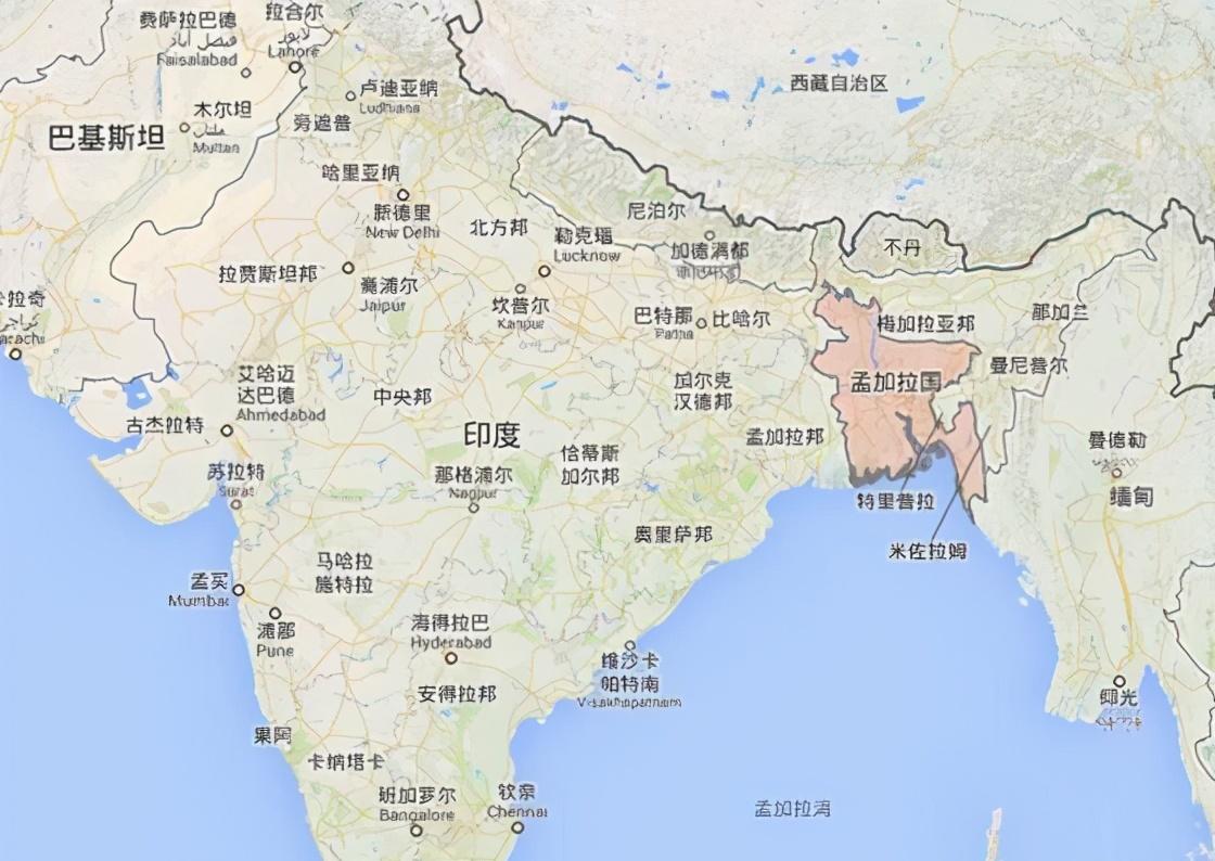
In fact, except for the Indus Valley region, which has long been Islamized, most of the entire subcontinent has not accepted Islam, but the Bengal region far from the Indus Valley has become an important breakthrough of Islam in the subcontinent - Bangladesh is located in the northeast edge of the South Asian subcontinent, only the west is adjacent to the Ganges Plain, the core area of India, and the north and east sides also seem to border India today, but they are already the fringes of Indian civilization. Historically, the northeastern region of present-day India has long been under the control of the Tibeto-Burman-speaking peoples.
Coupled with the geopolitical barrier of the Deccan Plateau, Bangladesh has actually made Bangladesh a weak area for The radiation of Indian civilization, which naturally makes the spread resistance of Islamic civilization in this area much less. However, after all, Indian civilization has been in Bangladesh for a long time, and Bangladesh is far away from other Islamic civilizations, so it has not been completely assimilated by Islamic civilization, but has formed a unique pattern of Coexistence of Islamic civilization in the east and Hindu civilization in the west.
At the end of the 17th century, some British who came to Bengal demanded the establishment of trade points in the area, and local officials casually gave the British a piece of land with poor conditions. However, in the eyes of the locals, the "poor land" is a treasure of feng shui in the eyes of the British: this place faces the river on three sides and the sea on the other. At the strategic level, it is easy to defend and difficult to attack, and economically it is the best place to build a deep-water port. The British built castles and recruited troops. As the population grew, it gradually developed into a large city – this is calcutta, the capital of the present-day Indian state of West Bengal.
In 1757, a large-scale war broke out between the British and the Bengali army in Prasi, in the Bengal region, for de facto control of Calcutta. The British won the Battle of Placi at the cost of seventy-five casualties, thus establishing the British dominance in the Bengal region. After the war, the British expanded from Kolkata to the entire Bengal region and even the entire Indian subcontinent, which eventually allowed Calcutta to become the capital of British India. In order to facilitate its rule, the British adopted a policy of division and disintegration against the princes of the Indian states.
Outside of the British territories, the United Kingdom still recognized the relatively independent rights of the princes of the native states. In religious matters, it is also divided between Hindus and Muslims. The withdrawal of the British from India was inevitable against the backdrop of the collapse of the British colonial system after World War II. Before the British withdrew from the Indian subcontinent in 1947, the former British Indian colonies were divided into two parts, India and Pakistan, according to the principle of religious belief, and india and Pakistan subsequently became independent states. The Mountbatten Plan uses religious belief as the sole basis for demarcating the India-Pakistan border.
The demarcation of the border did not take into account historical, cultural, ethnic and other factors, so in the actual partition of India and Pakistan, it was inevitable to encounter some embarrassing situations: the eastern residents of Bengal at that time mainly believed in Islam, while the western region mainly believed in Hinduism. So the Bengal region was divided in two in a partition plan centered on religious principles: the Hindu western part of Bengal was divided into India and eventually evolved into the present-day State of West Bengal in India; the Eastern Part of Islam was divided into Pakistan.
However, this move lays a major hidden danger: East Bengal does not border Pakistan itself, and the two are separated by India's vast territory. The bulk of Pakistan was located in the western region, and the bengal region in the east (then known as East Pakistan) effectively became an enclave far from the mainland. Even in today's few countries with enclaves, where information and information are quite developed, it is conceivable how difficult it is to control such an enclave in South Asia in the last century with Pakistan's national strength.
The partition of India and Pakistan is based entirely on religious beliefs, while ignoring that East and West Pakistan are almost completely culturally distinct in terms of ethnicity except religious beliefs: the dominant ethnic group in West Pakistan is Punjabi, followed by Sindhi, Pashtun and Baluch, whose official language is Urdu; the dominant ethnic group in East Pakistan is Bengali, whose mother tongue is Bengali. Pakistan's central government, in order to tighten its grip on East Pakistan, far from home, has imposed the Urdu language here in an attempt to assimilate East Pakistan completely.
However, this provoked strong resistance among the people of East Pakistan. At the same time, Pakistan has always been partial to the western mainland in domestic economic construction, and has not been too concerned about the eastern enclaves. Over time, the enmity between the two sides accumulated day by day. The combination of geographical isolation, great ethnic, cultural and linguistic differences and the perceived unfair treatment of the people of the East has made East Pakistan increasingly centrifugal towards the central Government of Pakistan. East Pakistan declared its independence on 26 March 1971.
In April of the same year, the provisional government of the People's Republic of Bangladesh was proclaimed in Calcutta, India, followed by large-scale unrest and refugee flows in East Pakistan. As an old rival, India will naturally not give up this great opportunity to attack Pakistan. India then sent troops to what was then East Pakistan, and the war then expanded to West Pakistan, culminating in the Third Indo-Pakistani War. On December 16 of that year, the Indian army captured Dhaka, the capital of East Pakistan, and the East Pakistan garrison surrendered unconditionally, and East Pakistan became an independent Bangladesh.
Today's West Bengal, Bihar, Tripura, Orissa and other parts of India are divided from the former West Bengal region, while the current Bangladesh People's Republic is evolved from the former East Bengal region. The area of Bangladesh is about 147,570 square kilometers; the area of West Bengal, India, is about 88,752 square kilometers. The population of Bangladesh is about 164.7 million; the population of the Indian state of West Bengal is about 96.7756 million. About 66 per cent of the population as a whole of Bangladesh is Muslim and about 33 per cent is Hindu.