Since October 29, there has been a continuous rainfall process in Guangxi, and heavy rain and heavy rain have also occurred in parts of northern Guizhou and central Guizhou. According to meteorological experts, there have been signs of excessive rainfall in Guangxi since October this year. According to statistics, from 8 o'clock on October 29 to 8 o'clock on November 1, there were 37 townships in 6 cities and 16 counties (districts) with more than 100 mm of rainfall, 433 townships in 68 counties (districts) in 11 cities with 50 to 100 mm, 443 townships in 76 counties (districts) in 13 cities and 76 counties (districts) in 25 to 50 mm, and the largest was Xianshui Town in Quanzhou County, Guilin City, reaching 151.7 mm.
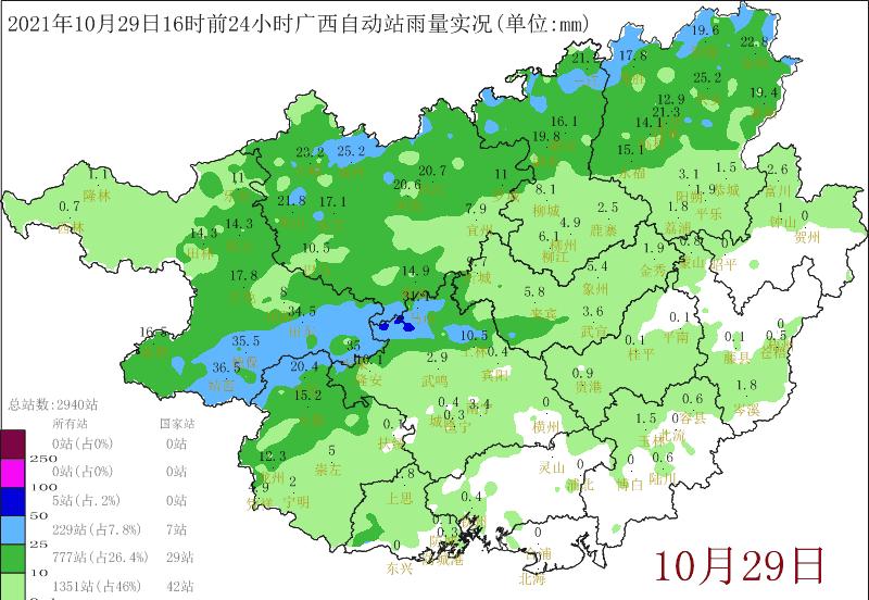
He Jielin, chief of decision-making service of Guangxi Climate Center: The average rainfall in October just this past was 136 mm, which is twice as much as the same period of the year. This year's rainfall can be ranked in the top 10 since 1951.

Meteorological experts analyzed that since October this year, Guangxi has received more rainfall, mainly due to the frequent and intense cold air, resulting in the average number of days of cold dew wind in Guangxi this year is more than usual, and another reason is that the two typhoon processes in October have brought rainfall. Meanwhile, in October, the average temperature in Guangxi was 21.5 degrees, 0.8 degrees lower than the same period of the year. Some citizens have questions: precipitation and temperature are quite different from previous years, will it be a manifestation of abnormal weather?
He Jielin, chief decision-making service of Guangxi Climate Center: Although the temperature this year is low, this is not a very extreme situation, and our temperatures in 2018 and October 2020 are lower than this year's situation. Meteorological experts expect that some parts of northern November will receive 10 to 20% more rainfall, and most of the rest will be 10% to 30% less; The average temperature is 0.1 to 0.5 °C in guibei and guizhong, and most of the rest are 0.1 to 0.5 °C.
Rain rain rain! In the three days from now, there will be heavy rain in the eastern and southern parts of Guangxi, and we need to be vigilant against secondary disasters
For three days from now (November 2 to 4), due to the joint influence of the low-layer shear line and the weak cold air on the ground, there will be continuous heavy rainfall in the eastern and southern parts of Guangxi, and the local area will be hit by heavy rainfall, and the local needs to pay attention to the secondary disasters that may be caused by local heavy rainfall.
The Guangxi Meteorological Observatory predicts that today, there will be moderate rain in some parts of Guilin, Liuzhou, Hechi, Laibin, Nanning, Chongzuo and other cities, with local heavy rain to heavy rain, and other areas with light to moderate rain on cloudy days.
The balance of cold air from the 3rd is insufficient! The South Wind family dominates! The maximum temperature in various places rebounds day by day, and the weather will develop all the way to "warm".
On the 3rd, Guinan is about 24 °C, Yulin and Beihai are 26 ~ 27 °C, everyone will feel that the weather is warm! By the 5th, the maximum temperature generally reached about 27 ° C, and some places have 29 ° C! This is the rhythm of the "summer" to be restored, and everyone's small fans are ready to come in handy again!
On the 4th and 5th, some places may still have sunlight temporarily showing their faces, but the air is generally humid, especially in some places in Guinan, moisture-proof measures should be taken. Rainy road slippery everyone needs to pay attention to the recent weather conditions in Nanning in the traffic safety zone
Guilin
Liuzhou
Wuzhou
Hezhou
Chongzuo
Bose
Guigang
River pond
Yulin
guest
Chin state
North Sea
Fangcheng Port