In January 1950, U.S. Secretary of State Acheson announced that the U.S. defense chain in the Far East would exclude the Korean Peninsula and Taiwan Islands from Alaska and the Aleutian Islands via the Kuril Islands, the Japanese Archipelago, and the Ryukyu Islands to the Philippines. This statement directly led Stalin to mistakenly believe that the United States abandoned the Korean Peninsula and agreed to Kim Il Sung's reunification of the Korean Peninsula, which can be said to be the reason for the outbreak of the Korean War. After the outbreak of the Korean War, the United States found that the United States in the Japanese archipelago was threatened if it lost the Korean Peninsula, so it quickly dispatched troops to intervene in the Korean Civil War. So where are these key islands?
<h1 class="pgc-h-arrow-right" data-track="2" >1, Aleutian Islands</h1>
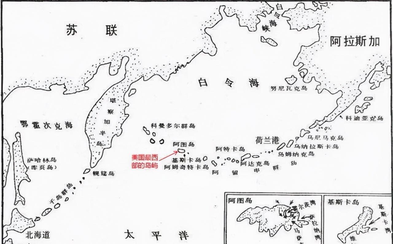
The Aleutian Islands are located between the Bering Sea and the North Pacific Ocean, stretching west from the Alaska Peninsula in North America to the Kamchatka Peninsula in Asia. It consists of more than 300 tiny volcanic islands (57 of which are volcanoes), 1,900 km long and a total area of 17,666 km². The Aleutian Islands are part of the Alaskan Peninsula, which was originally part of Tsarist Russia and was purchased by the Americans in 1867 for $7.2 million from Tsar Alexander II of Russia. Alaska and the Aleutian Islands on the map are the most important places in the North Pacific ocean in the form of the last quarter moon, which is a strategic point for the United States in the northern part of the Pacific Ocean, the shortest road from Japan and the Far East to North America and Northern Europe, and the closest place between the United States and Russia. The Aleutian Archipelago consists of five groups of archipelagos, Fox, Andreyanov, Four Hills, Rath and Neal, with a total of 159 large and small islands, a total area of about 18,000 square kilometers, and a population of about 8,000, of which the main garrison, the rest are indigenous. Among the archipelago, there are only 3 excellent ports, of which it is close to the former Dutch port on the east coast of the Alaska Peninsula, which has strategic value in the military and has always been a US naval and air base. At the northwest tip of the Aleutian Islands is Atul Island, the final island in the U.S. territory and the closest island to Russia. The island has many harbors and dangerous situations, and is a natural anchorage for ships. The United States has a 11,000-kilometer-kilometer National Wildlife Refuge between the archipelago of Unimak and Attu. The inhabitants live mainly on the three islands of Unalaska, Edak and Shemiya, engaged in fishing and the domestication of fur beasts. The archipelago is strategically important and is an important naval and air base for the United States in the Pacific. Adak Island and Shemiya Island are air transport relay stations; Dutch Harbor on Unalaska Island is a natural deep-water port, naval base.
<h1 class="pgc-h-arrow-right" data-track="6" >2, Kuril Islands</h1>

The Kuril Islands are located between the Kamchatka Peninsula in Russia's Far East and the Japanese island of Hokkaido, separating the northwest Pacific Ocean from the Sea of Okhotsk. It is 1,300 km long and consists of 56 islands. The Kuril Islands are now under the jurisdiction of The Sakhalin Oblast of Russia, with the Ainu (Ainu) ethnic group as indigenous people. The Kuril Islands are a natural barrier in the southeastern part of the Sea of Okhotsk, and the evolution of the sea lanes between the Sea of Okhotsk and the Japanese-Russian control zone between the Sea of Okhotsk and the Kuril Islands in the Pacific Ocean is of great strategic importance. Historically, Japan and Russia fought fiercely over the Kuril Islands. In 1855, Russia and Japan decided that the southern part of the Kuril Islands belonged to Japan, the northern part belonged to Russia, and Sakhalin Island was temporarily pending. In 1875, the two countries signed the Treaty of Exchange between Birch Pacific and the Northern Kuril Islands, which exchanged the southern part of the Japanese-occupied Sakhalin Island with the northern part of the Russian-occupied Kuril Islands. After the Russo-Japanese War of 1905, Japan recaptured the southern part of Sakhalin Island, which had been exchanged for Russia, and seized most of Russia's interests in the Far East. In 1945, the former Soviet Union sent troops to the northeast to retake the southern part of Sakhalin Island and the Kuril Islands. The Yalta Agreement of 1945 provided that the entire Kuril Islands was transferred to the former Soviet Union, and the southern Kuril Islands, Iturup, Schkotan and Hbamay Islands in the southern part of the Kuril Islands were assigned to the former Soviet Union after the war, but Japan did not recognize them. After the end of the Cold War, due to the decline of national strength, the Russian naval strategy changed from "ocean-going offensive" to "coastal defense", and the Russian Pacific Fleet shrank from the Aleutian Islands in the Central Pacific and the North Pacific to the Bering Sea, and shrunk to the Sea of Okhotsk and the outside of the Kuril Islands. At the same time, some naval bases on the Kuril Islands were closed, and the number of troops stationed was greatly reduced. In recent years, however, russia has begun to strengthen the military strength of the Kuril Islands in order to restore its status as a naval power. In 2002, after an inspection of the Far East, the Chief of the General Staff of the Russian Army decided to increase the garrison of the Kuril Islands and reopen the closed military bases. At the same time, the Russian military has also held large-scale military exercises in the Kuril Islands on many occasions. The Kuril Islands have once again become an important bridgehead in the Russian Far East base group. The archipelago is mainly composed of volcanic reefs, with 160 volcanoes, of which 38 are active volcanoes, known as the Pacific Ring of Fire. Earthquakes are frequent, averaging once every three days, mostly undersea earthquakes, followed by tsunamis. The peaks of the islands are towering and rugged, with more than 40 peaks above 1,000 meters, and Mount Aled is the highest, with an altitude of 2339 meters. The island has short rivers, rocky beaches and waterfalls. Most of the coast of the archipelago is steep cliffs, with a tortuous shoreline, deep coastal waters, and good harbors. The single crown bay of The island is deep and wide, suitable for a large number of ships to berth in covert harbor. During World War II, the Combined Japanese Fleet that attacked Pearl Harbor was assembled and hidden in Single Crown Bay. The Soviets built airfields on Kunio Island and Zekura Island for heavy bombers to take off and land.
<h1 class="pgc-h-arrow-right" data-track="13" >3, The Japanese Archipelago</h1>
The Japanese archipelago, the Japanese archipelago, located on the western side of the North Pacific Ocean, is part of a series of curved islands on the western edge of the Pacific Ocean, consisting of four large islands of Hokkaido, Honshu, Shikoku, and Kyushu, and more than 3,000 small islands nearby. Four of the largest islands account for 98% of Japan's total area, with Honshu Island being the largest. Because these islands are japanese territory, they are called Japanese archipelagos. The formation of the Japanese archipelago dates back to ancient times, and it is integrated with the Asian continent and is located on the eastern edge of Chinese mainland. Later, due to the orogeny of the Pacific Rim, the earth's crust continued to undergo drastic changes, separating Japan from the Asian continent. The horizontal topography of the Japanese archipelago is characterized by its narrow and long islands, tortuous coasts, and numerous bays, so that any part of the archipelago is within 100 kilometers of the coast. Japan's surface is rugged and mountainous, the plain area is narrow, and the mountains and hills are the most dominant in the topography of the archipelago, according to statistics, 75% of the area of The Japanese state is mountainous and hilly, of which pure mountainous land accounts for 60% of the country's land. The direction and arrangement of the mountains are mostly parallel to the coast, divided into two belts, the inner belt is located on the side of the Sea of Japan, mainly including the larger mountain ranges such as Okuwa, Echigo, and Hida; the outer belt is located on the Pacific side, mainly including the mountains of Kitakami, Abukuma, Kanto, Kiso, Kii, Shikoku, and Kyushu. The plains and low mountains of the Japanese archipelago account for only 13% of Japan's area, and the Kanto Plain near Tokyo Bay is the largest plain in the country, with an area of 16,000 square kilometers and an altitude of only 50 meters. There are also the Noo Plain near Nagoya, and the Kiuchi Plain around Osaka and Kyoto.
<h1 class="pgc-h-arrow-right" data-track="22" >4, Ryukyu Islands</h1>
The Ryukyu Islands are located in the eastern periphery of the East China Sea, with a total length of more than 1,000 kilometers from north to south, in a northeast-southwest direction, with the Osumi Islands, The Tugala Islands, amami Islands, Oshima Islands, Daito Islands and Xiandao Islands, with a total of more than 60 inhabited islands and more than 400 unnamed small islands. Historically, the Ryukyu Islands have long belonged to China's sphere of influence. It is about 700 kilometers away from Shanghai, Ningbo and Wenzhou on the coast of China. Before 1871, there was the Ryukyu Kingdom, which stretched from Amami Oshima Island in the north, Kikai Island in the east, Haruma Island in the south, and Naguni Island in the west. It is under the jurisdiction of Japan, a country defeated in World War II, but the administrative power in some areas is still exercised by the United States, and about 70% of the US military bases in Japan are concentrated in Ryukyu. In 1972, the U.S. military handed over the Ryukyu Islands to the Japanese Trusteeship (sovereignty does not belong to Japan), and the Ryukyu people gathered to protest the US military's denial of their right to independence and self-determination. From north to south, the Ryukyu Islands include the Osumi Islands, the Togaura Islands, the Amami Islands, the Oshima Islands, the Okinawa Islands, the Daito Islands and the Senjima Islands, with a total of more than 60 inhabited islands and more than 400 unnamed islets. [1] It has an area of more than 4,600 square kilometers and a population of over 1.4 million (1985). The highest point is Mt. Miyanoura at an altitude of 1,935 meters (Yakushima Island in the Osumi Islands). Subtropical oceanic monsoon climate, changxia island, annual precipitation of 2,000-3,000 mm, typhoons. Sugar cane and pineapple are two specialties, and sweet potatoes are also produced. There are also many pigs and cattle. Offshore fisheries are well developed and tourism is flourishing. There are international universities and Ryukyu Universities on the island of Ryukyu. The two largest islands are Okinawa (1,204 km2 [465 sq mi]) and Amami Oshima (712 km2 [275 sq mi]). These larger islands were originally volcanic and mountainous, while the smaller islands were mostly coral islands and were relatively flat. It has a subtropical oceanic monsoon climate with abundant rainfall and typhoons every year.
<h1 class="pgc-h-arrow-right" data-track="25" >5, Philippine Islands</h1>
The Philippine Archipelago, part of the Malay Archipelago of Southern Asia. It is bordered by the South China Sea to the west and the Pacific Ocean to the east. The archipelago, made up of more than 7,100 islands, is the territory of the Philippines. The Philippine Archipelago is separated from Taiwan by the Bashi Strait to the north, the South China Sea to the west, the Pacific Ocean to the east, Indonesia and Malaysia's Sabah State to the south, and the Philippine Sea to the northeast and the Mariana Islands. The rain is abundant here, and flowers, plants, and fruit trees are flourishing. The bananas, pineapples and mangoes produced are well known in the international market. Therefore, the Philippine Islands enjoy the reputation of "Pacific Fruit Plate" and "Garden Island". Most of the Philippine archipelago is made up of mountains, plateaus and hills. There are many active volcanoes and frequent earthquakes. Mount Apo in Mindanao is the highest mountain in the Philippines, and Mount Mayon in Luzon is the largest active volcano in the Philippines. The main rivers are the Mindanao River and the Cagayan River, and Bay Lake is the largest lake in the country. The economic composition of the Philippine Islands is mainly agricultural and industrial, with a particular emphasis on food processing, textiles and garments, and electronics and automotive components. Most of the industry is concentrated on the outskirts of Metro Manila , and cebu metropolitan area has recently become another location for foreign and local investment , the Philippines still has great potential for mining , the Philippines has a large reserve of chromite , nickel and copper , and the recent discovery of natural gas on the outer islands of Pala Bay has also joined the Philippines' rich geothermal , hydropower and coal energy reserves.