Yang Yongnian (1929- ) male - a native of Kunming, Yunnan - a senior engineer in the Planning Department of Sichuan Electric Power Company - has long been engaged in hydropower construction, operation and planning
In 2001, he published the paper "South-to-North Water Diversion Project and Preliminary Exploration of West-to-North Water Diversion Project" "Sichuan Water Conservancy and Power Generation"
Yang Yongnian analyzed the relationship between water transfer and power generation from the perspective of hydropower experts, and proposed that both water transfer and balance the interests of southwest hydropower bases should be balanced. At the same time, a large amount of detailed hydrological information along the line is given. Today, 20 years later, this solution is more feasible.
< h1 class="pgc-h-arrow-right" > basic assumption:</h1>
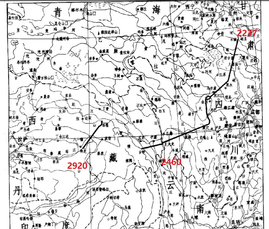
Construct a reservoir in the upper reaches of the Great Bay of the Brahmaputra River, to contain floodwaters, and to build a water inlet on the bank of the reservoir to divert water from the tunnel, open up the Watershed of the Brahmaputra River and the Nu River, the Tanggula Mountain, and divert water into the Nu River; Construction of a regulating reservoir on the Nu River; In the upper reaches of the reservoir to open the watershed of the Nu River and the Lancang River, he read Ta Weng Mountain and used tunnels to divert water to the Lancang River; Build the planned Guxue Reservoir on the Lancang River, regulate the runoff, open up the watershed between the Lancang River and the Jinsha River - Yunling Ridge in the upper reaches of the Guxue Reservoir, and use tunnels to divert water into the Wang Dalong Reservoir in the Jinsha River plan. The Brahmaputra River diverts about 55 to 60 billion m3, and the Nu River diverts about 23 to 40 billion m3, for a total of about 80 to 100 billion m3. After the regulation of the Wang Dalong Reservoir, about 60 billion m3 of water is diverted from the tunnel, through the edge of the Western Sichuan Plateau, into the Dadu River Shuangjiangkou (Yanwang Wang Bian) Reservoir, after the regulation and storage, continue along the edge of the West Sichuan Plateau along the northeast, through the MinShan Into the Tao River in Min County, Gansu Province, from the Tao River into the Liujiaxia Reservoir on the main stream of the Yellow River. In addition, about 40 billion m3 runoff flows into the cascade power stations of the downstream Jinsha River Hydropower Base after generating electricity at the Wang Dalong Power Station, flows into the Three Gorges Reservoir after generating power, and is transferred to the north through the middle line of the South-to-North Water Diversion Project, and the rest is discharged downstream after generating electricity through the Three Gorges and Gezhouba.
The elevation of the original Tongtian River, Yalong River and Dadu River diversion scheme is about 4,000 m, while the water elevation of the Brahmaputra River and nu River is low, and the elevation of the brahmaputra inlet is only 2920 m, the elevation to the JinshaJiang Wang Dalong Reservoir is 2460 m, the elevation to the Tao River, a tributary of the Yellow River, is 2237 m, and the elevation to the Liujiaxia Reservoir is 1735 m, and the whole line adopts the artesian method of water transfer. From the Wang Dalong Reservoir to the Three Gorges Reservoir, all the water is diverted by natural rivers.
<h1 class="pgc-h-arrow-right" > the current state of water resources</h1>
China is a water-scarce country in the world, although the total amount of water resources in the country ranks fifth in the world, but according to the average population of China ranks 109th, and the regional distribution of water resources is uneven, water and soil resources are unbalanced. The distribution of water resources in China is more in the southeast and less in the northwest, decreasing from the southeast to the northwest. The annual precipitation in the vast area south of the Huai River and the Qinling Mountains, as well as in Yunnan, Guizhou, most of Sichuan, and southeast Tibet, is greater than 800 mm; Most parts of Northwest and North China receive less than 400 mm of annual rainfall. The annual runoff of the Yangtze River is about 1,000 billion m3, the Yellow River is 58 billion m3, the Huai River is 53 billion m3, and the Haihe River is 28.3 billion m3. Due to the uneven distribution of water resources, after the founding of New China, a plan for diverting water from the Yangtze River to the north was proposed.
After decades of hard work, the South-to-North Water Diversion Project has made great progress. The Eastern Route Water Transfer Project pumps water from the Jiangdu Pumping Station in the lower reaches of the Yangtze River, north along the Beijing-Hangzhou Grand Canal, passing through Hongze Lake, Luoma Lake, Nansi Lake, Dongping Lake and other lakes to send water to Tianjin. The total length of the diversion line is 1150km, the water supply range includes Jiangsu, Shandong, Anhui, Hebei, Tianjin and other 5 provinces (cities), the general annual water transfer is 19.2 billion m3, in the Huai River is dry year, the Yangtze River water can be adjusted 30 billion m3. Construction began in the 1960s and was basically completed by the 1990s.
The central water transfer scheme is to draw water from the Danjiangkou Reservoir of the HanJiang River, a tributary of the Yangtze River, and the reservoir was built with the head of the Tao Fork Diversion Han General Canal at the time of construction, which is the starting point of the central line of the South-to-North Water Diversion Project. At the initial water level of Danjiangkou Reservoir at 155m, 500 m3/s of water can be diverted, and the annual water transfer volume is about 14.5 billion m3; After the reservoir dam is raised, the normal high water level is raised to 170 m, and the maximum quoted flow can reach 1200 m3/s, which is about 37.8 billion m3 per year. The main canal of the central line plan is 1240km long and directly sends water to Beijing. Recent water supply range of 23 567 km2, including 11 large and medium-sized cities such as Beijing, 33 county seats, irrigated farmland 15250,000 hm2. Henan section of the main trunk canal left 49 water diversion, the main trunk canal in Zhengzhou through the tunnel through the Mountain, in Gubaizui from the underground through the Yellow River, the main trunk canal basically along the west side of the Beijing-Guangzhou Railway north, after the completion of the Yangtze River Three Gorges Reservoir, will be drawn from the Three Gorges Reservoir, the annual water transfer of about 29.1 billion m3, 1999 began construction preparations, the construction period is expected to be about 6 years.
The problem of the western route of the South-to-North Water Diversion Project is more complicated. The Yellow River is an important water source in the northwest and north China, but the annual runoff is only 58 billion m3, the farmland irrigation area in the basin is 4.4 million hm2, and the irrigation area outside the basin is 930,000 hm2, a total of about 5.33 million hm2, plus urban industrial water, domestic water, with the implementation of the strategy of large-scale development of the western region, the water shortage problem in the northwest and north China will be more serious.
In order to solve the problem of insufficient water resources, on the one hand, we must do everything possible to save water and improve people's awareness of water conservation. On the other hand, it is also necessary to try to divert water from outside the region, such as the eastern and central lines of the south-to-north water diversion project, which have played an important role in alleviating the shortage of water sources in the Beijing-Tianjin region, Henan, Hebei, Shandong, Anhui and other places, but the problem of water shortage in the northwest region, the upper and middle reaches of the Yellow River must also be solved by the western line of the south-to-north water diversion.
The problem faced by the western water transfer project is that the Tongtian River in the upper reaches of the Yangtze River and the Jinsha River, Yalong River and Dadu River are proposed hydropower bases. Dadu River has now built two large hydropower stations in Gongzui and Tongjiezi, with a total installed capacity of 1.3 million kW, and is now preparing to build a waterfall ditch power station with an installed capacity of 3.3 million kW; The Ertan Power Station has been built on the Yalong River, with an installed capacity of 3.3 million kW, and is preparing to build the upstream Jinping I, II, Guandi and downstream Tongzilin and other power stations.
Sichuan Province is short of coal and oil, and the main supplementary power supply for development in the 21st century is to rely on hydropower, and these two hydropower bases can install a total of 36 million kW, which will be the main power supply point in Sichuan in the future. The original plan for the western route to divert water to the Yalong River is 6.5 billion m3 and the Dadu River is 2.5 billion m3, which will cause the annual loss of electricity of the Ertan Power Station to be 2.137 billion kW·h, or 745 million yuan; The Gongzui and Tongjiezi power stations lose 350 million kW·h of electricity per year, or 122 million yuan, which does not take into account the loss of industrial output value. Therefore, it is not appropriate to divert water from these two rivers, but reservoirs can participate in the regulation of runoff in the diverted water.
The Jinsha River is also a large-scale hydropower base to be built, and it is also the main power supply point for the transmission of electricity from the west to the east, which is planned to be gradually developed in the 21st century to transmit electricity to coastal areas such as East China and Guangdong. The adjustable water volume of the Tongtian River in the upper reaches of the Jinsha River is not much, and the annual average flow measured at the Tongtianhe Zhimenda Hydrological Station is 403 m3/s and the annual runoff is 12.7 billion m3, and to the Wang Dalong Hydropower Station in Batang, Sichuan, the annual average flow rate increases to 986 m3/s, and the annual runoff is 31.1 billion m3. If the water is transferred from the Tongtian River by 8 billion m3, the usable water of the Tongtian River has been basically dimmed, and if the water is taken from the downstream Wang Dalong Reservoir, the maximum water diversion is only 30 billion m3. When transferring 10 billion m3 of water, the Jinsha river hydropower base will have 6.25 million kW less installed capacity, and if the water is transferred 30 billion m3, it will be 18.77 million kW less installed, and the impact is very large.
In order to solve the problem of the Yellow River and the Yangtze River competing for water in the upper reaches, the "West-to-North Water Diversion Project" is the way to solve this problem. Due to the shortage of water in the northwest and north China, it has aroused the concern of some people at home and abroad, such as comrade Guo Kai in China who proposed the "Shuotian Canal" plan (see "China's Old Year"), and Mr. Xu Xiuhui proposed the plan of "West-to-East Water Diversion" (see "Sichuan Hydropower" Magazine, No. 1 and 2, 2001), all of which put forward the issue of water diversion from the Brahmaputra River, which is worth studying. But to implement, a lot of work is to be done.
"Xishui" refers to the three rivers in western China, such as the Brahmaputra River, the Nu River, and the Lancang River, and the "northern diversion" refers to the partial runoff of these three rivers through the Hengduan Mountains and introduced into the Jinsha River, and then the Jinsha River will send the water to the upper reaches of the Yellow River and the Three Gorges Reservoir respectively, and through the middle line of the South-to-North Water Diversion To the north. The Red River and the Irrawaddy River in the west are located southward due to their low elevation and are not within the scope of water transfer. The Lancang River is also a large hydropower base under construction, and two power stations have been built, Manwan and Dachaoshan power stations, and xiaowan power stations are being built. Moreover, the Lancang River may become a waterway to East Asia in the future, and it is not appropriate to participate in water transfer, but reservoirs can participate in runoff regulation.
<h1 class="pgc-h-arrow-right" > the hydrology of the water source</h1>
The Brahmaputra River originates in the northern foothills of the Himalayas in southwest Tibet, flows from west to east through Shigatse, Zedang and other places, and begins to form a large river bay near the lower Pai district of Milin County, which turns south and flows southwards into India through China's Basika. The annual average flow at the exit is 4425 m3/s and the annual runoff is 139.5 billion m3.
The Nu River originates in Amdo County, the southern foothills of the Tanggula Mountains in Tibet, flows from north to south, and flows into Myanmar through Yunnan, with an average annual flow of 1840 m3/s and an annual runoff of 58 billion m3.
< h1 class= "pgc-h-arrow-right" > the Nyingchi Reservoir, the first hub of the West-to-North Water Diversion Project</h1>
<h1 class="pgc-h-arrow-right" > the development of hydropower in the Brahmaputra River has been included in the 14th Five-Year Plan</h1>
After years of research, the development plan of the Brahmaputra River has 12 cascade power stations such as Gangke, Renqingding, PengCulin, Solanggagu, Gacha, Langxian, Rixue, and Metuo, among which the Metuo power station is the largest and has a large reservoir, located in the lower reaches of the Brahmaputra River, with a large rain collection area, a large annual runoff, closer to the Nu River, a shorter diversion line, a relatively moderate location of the reservoir, better traffic conditions, and a normal high water level to maintain a certain elevation, which is convenient for artesian water diversion. Due to the above reasons, the first hub of the West-to-North Water Diversion Project should be selected in the Pian District of Nyingchi County, combined with the first hub of the Metuo Power Station for construction.
Metuo Power Station is a huge power station that uses the lower reaches of the Brahmaputra River to divert water to generate electricity, with a control basin area of 190 520 km2, accounting for 79% of the 240 480 km2 area of the Brahmaputra River basin. The annual average flow rate is 1 890 m3/s. The barrage is located near Duoxiong and Jabang in Pai District, Nyingchi County, between the Pai District and the downstream canyon inlet, the barrage dam has a height of 70 m, the total reservoir capacity of 11.5 billion m3, the effective reservoir capacity of 7.5 billion m3, the normal high water level of 2 950 m, the stagnant water level of 2 920 m, and the reservoir returns to Nyingchi County and Milin County. This reservoir is referred to as Nyingchi Reservoir. Metuo power station is the use of the terrain of the big river bay, cut and straighten, through the 39 km tunnel to divert water to the downstream of the Metuo near the Lidong Bridge to build a plant to generate electricity, the power station gross water head 2 300 m, citation flow of 2 170 m3 /s, installed capacity of 38 million kW, annual power generation of 228.5 billion kW·h. The scale of the Metuo power station is huge, the geographical location is west, it is very far from the power consumption center, the region can not use this power for a long time, the power transmission is also very difficult, and many technical problems in the construction of the power station cannot be solved now. Therefore, changing power generation to water diversion is also a good way to make full use of water resources.
There is a nuxia hydrological station near the Nyingchi Reservoir, which has hydrological data from 1956 to 1978, and the main data after collation are as follows:
Control basin area (km2) 189 834
The annual average flow rate (m3/s) is 1 890
The maximum and minimum annual average flow (m3/s) is 2 870 to 1 490
The maximum annual and minimum annual runoff (100 million m3) is 905~470
Maximum peak flow (m3/s) 12 700
The driest flow rate (m3/s) is 364
The annual average runoff (billion m3) is 596
The maximum flood and dry water level difference (m) is 11.04
The annual average sand content (kg/m3) is 0.284
The average annual sediment transport (10,000 t) is 1,900
The interannual variation of the Brahmaputra Runoff is not large, the distribution is uneven during the year, the rainy season from June to September accounts for 72% of the annual runoff, November to April accounts for 15% to 18% of the annual runoff, the largest monthly runoff generally occurs in August, and the driest flow occurs in February to March.
According to the analysis of hydrological data, the annual water transfer from Nyingchi Reservoir is about 60 billion m3, and the main water transfer time is from June to September of the flood period, that is, about 43.2 billion m3 of water should be transferred out in these four months. When the capacity of Nyingchi Reservoir is not considered, the flow rate is 4166 m3/s; If the reservoir is considered to store water during this period, the flow rate is 3449m3/s. Comprehensively considered, it is roughly estimated that four pressure tunnels with a diameter of 16 m are used to transport water, each tunnel is about 900 m3/s, a total of 3600 m3/s, and the water can be adjusted by 37.5 billion m3 in 4 months from June to September. The remaining 22.5 billion m3 can be transferred within October to May of the following year.
The dam site of Nyingchi Reservoir is hard gneiss, the riverbed cover is deep, and the cover layer of the bridge foundation of the Dongga Bridge in Milin County upstream is greater than 50 m, which can be used as a reference. The intensity of the earthquake is about 6.5 to 7.5 degrees.
The water of the Brahmaputra River has a small sediment content, but the annual sediment transport volume is still 19 million t, and in order to make the reservoir long-term use, the barrage should still be equipped with flood discharge and sand discharge facilities to reduce the siltation of the reservoir.
After the construction of Nyingchi Reservoir, it is also hoped that the upstream Gangke, Gulu, Renqingding, Peng Cuolin, Solang Gagu, Gacha, Langxian and other reservoirs will be built successively, which have a total capacity of 9.4 billion m3, which can increase the regulation capacity and intercept the sediment upstream, and the construction of these reservoirs will play an important role in the development of Tibet's local economy.
The first hub should have two water inlets, one is reserved for the Metuo Power Station, the scale of which is determined according to the local power long-term plan of Tibet. Another inlet is the inlet of the water transfer, which should be located on the shore of the Nyingchi Reservoir, and the top elevation of the inlet of the diversion tunnel should be slightly lower than the stagnant water level of the reservoir. Anti-sediment measures should be taken to reduce sediment accumulation.
After the completion of the Nyingchi Reservoir, it will not cause adverse environmental impact to the downstream, because the de-flow section is not long, there is a palon zangbu injection, there are more tributaries injected into the great river bay, and the annual runoff from the Bashika outflow of the national border is still 79.5 billion m3, and the flood is basically intercepted, which will play an important role in reducing the flood disaster downstream.
<h1 class= "pgc-h-arrow-right" > 200 km tunnel from Nyingchi Reservoir to Nu River</h1>
Four pressure tunnels with a diameter of 16 m are transported, each tunnel is about 900 m3/s, a total of 3600 m3/s, and the water can be adjusted by 37.5 billion m3 in 4 months from June to September.
The total length of the line from Nyingchi Reservoir to the Nu River is about 200 km, due to the complex terrain, the large amount of citation flow, and to maintain a certain elevation, and to cross the Brahmaputra River and the Nu River watershed Ofsula Ridge, along the line to use pressure tunnels to divert water. The starting point of the tunnel is the Nyingchi Reservoir, the top elevation of the tunnel is 2 920 m or slightly lower, the slope of the tunnel is 1‰, the exit of the tunnel should be slightly higher than the water surface of the Nu River, which is convenient for connecting with the water flow of the Nu River, and the specific cave line should be determined in the survey design. In addition to crossing the watershed section, multi-facility engineering support holes should be sought along the line to facilitate construction.
The tunnel goes north from the water intake of the Nyingchi Reservoir, through the Igong Tsampo, along the southern foothills of the Tanggula Mountains, and in the appropriate position through the Bersula Ridge, with a total length of about 200 km. If the slope is 1‰, the elevation of the tunnel exit is about 2700 m.
<h1 class= "pgc-h-arrow-right" > the Nu River water diversion and nu river reservoir</h1>
The Nu River originates in Amdo County, the southern foothills of the Tanggula Mountains in Tibet, and basically flows from north to south, with a basin area of 124,830 km2, of which 103,330 km2 is in Tibet, 21,500 km2 in Yunnan, and the total length of the main stream is 2,013.4 km. Among them, tibet is 1 392.4 km, and Yunnan is 621 km. The Nu River flows from Tibet to Yunnan near Chaqilong, flows through Yunnan to Myanmar, called the Salween River, and finally flows into the Andaman Sea in the Indian Ocean. The Nu River is bordered by the Bersula Ridge Mountains, which is the watershed between the Nu River and the Brahmaputra River; To the east, he reads The Mountain of Ngong, which is the watershed of the Nu River and the Lancang River. The Nu River is turbulent, with an average ratio of 2.67 ‰ in Tibet and an average annual flow of 1,840 m3/s in the country. The Nu River has rich hydropower resources, and the river drop is relatively uniform, but there is no better reservoir terrain along the river, and it can only be developed as a dam, relying on increasing the dam height to obtain the reservoir capacity. Since no comprehensive survey and planning work has been done on the section of the river in Tibet, data are scarce, and it is not possible to select the location of the Nu River Reservoir or the outlet location of the Brahmaputra River Diversion Tunnel. This will be determined by further work in the future. The main use of water resources in the Nu River is power generation, in Yunnan Territory, the Nu River dam and farmland along the river have irrigation water requirements, but there are many small and medium-sized tributaries along the river, most of which can be solved by self-flowing water diversion on tributaries. The Nu River beach is full of water emergencies and there are no shipping requirements. The nu river hydropower resources are not planned in Tibet, and 6 cascades, including Busi, have been planned in Yunnan, with a total installed capacity of about 10 million kW, but the geographical location is westward, far from the load center, close to the national border, and it is impossible to develop for a long time. To this end, considering the transfer of water from the Nu River is also a way to make full use of the water resources of the Nu River. When conditions permit in the future, the water energy resources in the upper and middle reaches can still be developed and utilized, and the utilization of hydropower resources downstream of the water transfer line should be planned separately and appropriately reduced in scale。
Since there is no hydrological station on the Nu River in Tibet, according to the data of the Busi Power Station in Gongshan County, Yunnan Province, the annual average flow of Busi is 1 487 m3/s and the annual runoff is 46.9 billion m3. If the dam is built in the appropriate position upstream to block the water, it is possible to divert 23 to 40 billion m3.
The location of the Nu River Reservoir can only be determined after the survey and design work has been completed, and in addition to meeting the needs of receiving incoming water from the Brahmaputra River and the upper reaches of the Nu River, it also needs to be coordinated with the elevation of the Guxue Reservoir in the Lancang River plan, and the tunnel that crosses the watershed ta Thakung Mountain is shorter.
<h1 class= "pgc-h-arrow-right" > 50 km tunnel from Zuogong of the Nu River to the Guxue Reservoir of the Lancang River</h1>
Preliminary estimates are that the location of the Nu River Regulation Reservoir is in the lower reaches of the Nu River near Zuogong, and the water from the Brahmaputra River flows into the reservoir through a natural channel, and it is estimated that about 7 tunnels with a diameter of 16 m are needed to divert water into the Lancang River Guxue Reservoir. The tunnel is about 50 km long. The tunnel exit elevation is about 2560 m, and the tunnel inlet elevation is about 2610 m.
< h1 class= "pgc-h-arrow-right" > the Lancang River Guxue Reservoir and the tunnel line into the Jinsha River</h1>
The Lancang River originates in the northern foothills of the Tanggula Mountains on the Qinghai-Tibet Plateau, flows into Yunnan through Tibet, flows out of the country in Xishuangbanna Prefecture, Yunnan Province, and flows into the South China Sea through Laos, Myanmar, Thailand, Cambodia and Vietnam, near Saigon. The average annual flow during the country is 2,180 m3/s.
Lancang River is one of the 10 major hydropower bases under construction in China, planning 16 cascades, of which Tibet has Zhenda and Guxue two levels, the rest are in Yunnan territory, the recent development focus is on the middle and lower reaches of the river, has been built Manwan, Dachaoshan two levels, installed capacity of 3 million kW, is now under construction Xiaowan power station, installed capacity of 4.2 million kW. By 2015, it is planned to complete the construction of five power stations, including Xiaowan, Manwan, Dachaoshan, Nuozhadu and Jinghong, with a total installed capacity of 12.81 million kW, and the remaining power stations will be gradually developed in the future to transmit electricity to Guangdong, Myanmar and other places. The lower reaches of the Lancang River can be navigable, and it is planned to build an international waterway to Southeast Asia in the future, so the Lancang River is not suitable as a water diversion source. However, the Xiaowan Power Station under construction on the Lancang River has an incomplete multi-year regulation reservoir of 15.265 billion m3, which can participate in the runoff regulation of water transfer, and can use the Xiaowan Reservoir to store more water during the flood period, and some water can be transferred to the north during the dry period.
Guxue Reservoir is a reservoir to be passed through in the water transfer route, and its location and elevation are suitable for the needs of the water transfer line. The planned Guxue Reservoir is located in the Mangkang area of Tibet, with an average annual flow of 668 m3/s, a normal high water level of 2 595 m, a dead water level of 2 563 m, a total reservoir capacity of 1.22 billion m3, an effective reservoir capacity of 520 million m3, and a water height of 215 m. Installed capacity of 1.2 million kW.
The task of guxue reservoir in the water diversion route is to intercept the runoff transferred from the Nu River and enter the Jinsha River Wang Dalong Reservoir through the tunnel. In addition to the water from the river, too much water can also be put into the downstream reservoir during the flood, and part of the water can be transferred to the north during the dry period.
The reservoir capacity of the ancient science reservoir is small, it is impossible to store a large amount of water to regulate the runoff, but the dam is very high, the amount of engineering is large, and the dam line can be further studied and adjusted in the next step of work, and the dam height can be reduced to reduce the amount of engineering, and it is also possible to appropriately reduce the storage capacity.
The annual runoff transferred from the Guxue Reservoir to the Jinsha River is still 100 billion m3, and it is estimated that seven tunnels with a diameter of 16 m are still needed to transport water, each tunnel is about 60 km long, the tunnel inlet top elevation is about 2 560 m, and the outlet top elevation is about 2 500 m.
Water and sand prevention measures should be taken at the entrance of tunnels, and river barrages should also be set up to discharge flood and sand gates in order to maintain storage capacity for a long time.
<h1 class="pgc-h-arrow-right" > JinshaJiangwang Dalong Reservoir</h1>
Located on the Jinsha River between Mangkang in Tibet and Batang in Sichuan, wang dalong reservoir is the seventh cascade power station in the Jinsha River plan. The control basin area is 181 890 km2, the annual average flow rate is 986 m3/s, the elevation of the dam site is 2 357 m, the normal high water level is 2 520 m, and the dead water level is 2 490 m; The total reservoir capacity of the reservoir is 14.1 billion m3, the regulated storage capacity is 4.1 billion m3, and the installed capacity of the power station is 2 million kW. The maximum head of the power station (high water) is 160 m. Wang Dalong Reservoir is a larger reservoir in the West-to-North Water Diversion Project, if from the need to divert water, the stagnant water level of the reservoir can also be appropriately reduced, which can increase the adjustment of the reservoir capacity, if the stagnant water level is reduced by 30 m, that is, the working depth is changed from 30 m to 60 m, which may increase the part of the regulation reservoir capacity.
The Wang Dalong Reservoir is a hub point in the water diversion route, the water transferred from the Brahmaputra and Nu rivers is redistributed through the Wang Dalong Reservoir, of which 60% passes through the edge of the Sichuan Plateau in northwest Sichuan, through the Shaluli Mountains and daxue Mountains, north along the Dadu River, into the Shuangjiangkou (Yanwang Wang Bian) Reservoir of the Dadu River. After the adjustment, the northeast along the foothills of the Minshan Mountains enters the Tao River, a yellow tributary in Min County, Gansu Province, and enters the planned Ancient City Reservoir at the Tao River, which flows into the Liujiaxia Reservoir on the main stream of the Yellow River through remediation (and power generation).
The other 40% of the runoff is discharged along the Jinsha River cascade power station after the Wang Dalong power station is generated, and finally enters the Three Gorges Reservoir, where it is redistributed at the Three Gorges Reservoir, and part of it is transferred to the Danjiangkou Reservoir and transferred along the middle line of the South-north Water Diversion Project to North China. The remaining part was discharged after generating electricity through the Three Gorges and Gezhouba power stations.
There are many large reservoirs in the Jinsha River plan that need to be built simultaneously in the West-to-North Water Diversion Project, such as Tiger Leaping Gorge (18.16 billion m3), Hongmen Gate (6.7/200 million m3), Leather Factory (88.2 m3), Baihetan (19.3 billion m3), Xiluodu (12 billion m3); The total reservoir capacity of the Jinsha River cascade is 76 billion m3, the total reservoir capacity of the Three Gorges is 39.3 billion m3, and the total storage capacity of the two is 115.3 billion mb.
Although the sediment content of the water from the Wang Dalong Reservoir is not large, the annual sediment transport volume is about 11.88 million t, but in order to maintain the storage capacity and enable the reservoir to be used normally for a long time, the barrage should have flood discharge and sand discharge facilities, and in the inlet design of the water diversion tunnel, attention should be paid to water diversion and sand prevention to prevent the siltation of the tunnel.
<h1 class="pgc-h-arrow-right" > the western line of the South-North Water Diversion Project diverted by the Wang Dalong Reservoir</h1>
It turned out that the western line of the South-to-North Water Diversion Project proposed by the relevant departments was diverted from the upper reaches of the Tongtian River, the Yalong River and the Dadu River, and their elevations were all about 4,000 m into the upper reaches of the Yellow River; The water diversion from Wang Dalong Reservoir has a low elevation, the stagnant water level of Wang Dalong Reservoir is only 2460 m, the normal high water level is 2520 m, the elevation of the water diversion to the Tao River is 2237 m, and the total drop is only 223 to 283 m, but the diversion line is long, the average drop per km is 03 ‰ ~ 0.4 ‰, and the flow rate of water in the tunnel is only about 3 m/s.
If the diversion tunnel starts from the Wang Dalong Reservoir and reaches the Shuangjiangkou (Yanwang Wang Bian) Reservoir of the Dadu River, the straight-line distance is about 350 km, but because it is necessary to bypass the Western Sichuan Plateau, it can only be along the edge of the Western Sichuan Plateau, and it must be maintained at an elevation of 2 460 to 2 340 m, through the Shaluli Mountains, Daxue Mountain and other mountains, and the route is estimated to be about 400 km long. After crossing the Shaluli Mountains, the cave line runs eastward, and after passing through the Daxue Mountains, it goes north along the Dadu River Valley until it reaches the Yamawangwang Bian Reservoir. The elevation of the tunnel into the Shuangjiangkou (Yanwangwangbian) reservoir should be about 2 340 m, keeping the tunnel ratio drop at about 0.3 ‰. After the regulation of the Shuangjiangkou (Yanwang wang bian) reservoir, the water diverted by the reservoir continues along the northeast, through the Minshan Mountains to the direction of Min county in Gansu, and in the appropriate place through the Minshan Mountains, into the Tao River Basin. The elevation of the top of the diversion tunnel from the Shuangjiangkou (Yanwangwangbian) Reservoir is slightly less than 2 340 m, and the elevation to the Ancient City Reservoir is 2 237 m, with a drop of 103 m, and the total length of the line is about 350 km, and the specific drop is only 0.3 ‰.
The route selection from the Wang Dalong Reservoir to the Ancient City Reservoir of the Tao River via the Shuangjiangkou (Yanwang Wang Bian) Reservoir is a complex and arduous task, with a total length of about 750 km, to cross many mountain ranges, to maintain a certain elevation, and to consider whether the geological conditions can be, so it is necessary to carry out the survey and design work very carefully.
Due to the long line and smaller than the drop, the flow rate of the tunnel is low, although there is a regulation of the Nyingchi, Wang Dalong and other reservoirs, but the annual runoff of 60 billion m3 is quoted, and it is estimated that 4 tunnels with a diameter of 16 m are still needed to transport water. However, in the end, it should still be determined by the survey design comparison.
< h1 class="pgc-h-arrow-right" > dadu river shuangjiangkou (Yanwang Wang bian) reservoir</h1>
The Shuangjiangkou (Yanwang Wang bian) Reservoir is located in Jinchuan County, Sichuan Province, and is the confluence of the Dadu River and the Zhuosijia River, the east and west sources of the Zumuzu River. After the confluence of the two sources, it was called the Dajin River, and it was renamed the Dadu River below Danba. The planned Shuangjiangkou (Yanwangwangbian) Reservoir has a control basin area of 39 322 km2, an average annual flow of 520 m3/s, the normal high water level of the original plan is 2 520 m, the stagnant water level is 2 460 m, the elevation of the dam site is 2 240 m, the total storage capacity is 2.8 billion m3, the effective storage capacity is 1.3 billion m3, and the installed capacity is 1.5 million kW. In order to match the water transport, the parameters of the original plan need to be adjusted. In order to cooperate with the water transfer of Wang Dalong Reservoir, the normal high water level should be reduced to 2 400m, and the stagnant water level, storage capacity and installed capacity should be adjusted accordingly. In the next step, the dam site of the reservoir and related parameters should be further studied.
<h1 class="pgc-h-arrow-right" > from the Taohe Ancient City Reservoir to the Liujiaxia Reservoir in the main stream of the Yellow River </h1>
The Tao River is a tributary of the Yellow River, with a total length of 673 km, a basin area of 22 527 km2, and an average annual flow of 163 m3/s. The river originally flowed from west to east, turning north near Min County, and was closest to the end of the Tunnel of the South-north Water Diversion Project, which could be selected as the outlet of the Tao River. From the outlet of the TaoHe River to the Liujiaxia Reservoir is about 200 km long, with a drop of about 500 m. After the diversion of water, the development scheme of this section should be re-examined as a result of the significant increase in flow, resulting in hydroenergy resource reserves in this section of the river reaching about 10 million kW. In the next step of the study, the following 3 problems will be solved:
(1) On the basis of the original plan, re-study the cascade development schemes of Shimen, Jiudian Gorge, Haidian Gorge and downstream, and make full use of hydropower resources;
(2) After the introduction of water into the tao, the flow rate increased greatly, and it is necessary to study the diversion of water to irrigate the Dingxi area in southern Gansu and the diversion of water to irrigate the Weihe River Plain;
(3) After the introduction of water into the tao, the flow of water increased greatly, along the river should be based on topographical conditions, combined with power generation, irrigation, shipping, etc. for comprehensive planning, especially the 140 km section below the Haidian Gorge, the river valley is open, there are more cultivated land, and embankments should be set up in some sections of the river, dredging the river channel, and comprehensive rectification should be carried out so that the water to be transferred can smoothly enter the Liujiaxia Reservoir. In this 140 km section of the river, there is a drop of 211 m and hydropower resources of about 4 million kW. Combined with river improvement, the development of low-head power stations is the next step to study the problem
<h1 class="pgc-h-arrow-right" > water storage and reservoir joint scheduling</h1>
In the entire West-to-North Water Diversion Project, after the regulation and distribution of the Wang Dalong Reservoir, 40% of the water volume to the Cascade of the Jinsha River and the Three Gorges Reservoir is relatively easy to solve. Transferring 60 percent of the yellow river's water volume is a very arduous water transfer project, but how to store this water and regulate its utilization is also a big problem. The reservoir capacity along the water transfer line is only more than 10 billion m3, and the amount of water entering the Yellow River is 60 billion m3, except for some of the irrigation in southern Gansu and the Weihe River Plain, most of which enter the Liujiaxia Reservoir and lead downstream. Liujiaxia, Yanpanxia, Bapanxia, Qingtongxia and other four power stations with a total storage capacity of only 6.7 billion m3, although the total reservoir capacity of the upstream Longyang Gorge is 24.7 billion m3, which can be adjusted for many years, but during the flood season, in order to generate electricity, there will also be part of the runoff flowing into the Liujiaxia Reservoir through the lasiwa, Lijiaxia and other power stations, in order to impound water, while the construction of the south-to-north water diversion project, it is also necessary to build the Daliushu Reservoir (10.6 billion m3), the Moraine Reservoir (12.4 billion m3) and the Longmen Reservoir (11.4 billion m3) on the main stream of the Yellow River at the same time. In this way, the reservoir capacity can be increased by 34.4 billion m3 in the upper and middle reaches of the Yellow River. In addition, it is also necessary to give play to the water storage function of various types of reservoirs in the irrigation system, including studying the water storage function of wuliangsuhai, so that the transferred water can be fully stored and utilized.
In addition to the upper and middle reaches of the Yellow River, as far as possible to store and utilize incoming water, we should also consider using part of the storage capacity of the Sanmenxia and Xiaolangdi reservoirs to store and transfer the transferred water for the use of the middle and lower reaches.
After the implementation of the West-to-North Water Diversion Project and the Western Line of the South-to-North Water Diversion Project, it will unite China's Brahmaputra, Nu, Lancang, Yalong, Dadu, Jinsha, and the Han River and the Yellow River in the middle reaches of the Yangtze River into a unified water network. For this water network, unified scheduling must be carried out in order to exert the greatest economic benefits.
<h1 class="pgc-h-arrow-right" > engineering benefits
</h1>
The main purpose of the West-to-North Water Diversion Project is to solve the problem of water shortage in northwest and north China, and providing sufficient water resources to northwest and north China is the greatest benefit. If 60 billion m3 of water can be transferred to the upper reaches of the Yellow River, it will be fully guaranteed for the development of irrigation and the satisfaction of industrial and urban domestic water. It is estimated that if the upper reaches of the Yellow River increase the amount of water by 20 billion m3, the irrigation area can be expanded by about 2.333 million hm2, of which 1.6 million hm2 is in the upper reaches of the Big Willow Irrigation Area and the Ningmeng Plain Irrigation Area, and about 733,000 hm2 in the middle reaches of the Longmen Irrigation Area. Under the condition of abundant water resources, it is also possible to further expand the irrigation area, change the farming system, gradually return farmland to forest on the Loess Plateau, do a good job in water and soil conservation, improve the ecological environment, and make it develop into an area for the comprehensive development of agriculture, forestry, and animal husbandry. Slowing down and curbing the development of desertification has gradually turned the Ningmeng Plain, the Ordos Plateau, and tens of millions of acres of desert in the Tengger Desert into oases. These issues require further study.
In terms of water supply in towns and industrial areas, with the strategic development of the country's western region, a large number of new industrial bases will be built along the Yellow River and neighboring areas, and the original industrial cities will be further developed. Nonferrous metals development zone centered on Lanzhou, Ningxia Dawukou, Lingwu, Yinchuan area, Inner Mongolia Dongsheng, Zungar, Baotou and other areas, Shaanxi Shenfu, Hancheng and other areas; In Datong, Liulin, Pingshuo, Taiyuan and other areas of Shanxi, the urban population of these industrial zones is expected to reach about 38 million in the medium and long term, and the industrial and domestic water demand will reach 19.5 billion m3. After the West-to-North Water Diversion, all of this water can be met.
After the West-to-North Water Diversion Project, the installed capacity and power generation capacity of some hydropower stations in the Yellow River Basin can be increased. As mentioned earlier, the hydropower resources of the Tao River could be increased by approximately 10 million kW. The section below Liujiaxia can increase the hydropower resource reserves by 29 million kW. In the Yangtze River Basin, it is beneficial to avoid "fighting for water" in the upper reaches and the Yellow River, and at the same time, after the water transfer, the runoff of 40 billion m3 is increased, which is discharged after generating electricity through the Wang Dalong Reservoir, and then enters the Three Gorges Reservoir after generating electricity through the Jinsha River cascade power station, which can increase the installed capacity by 28 million kW, thus bringing great economic benefits.
After the west-to-north water diversion, it has positive significance for improving the allocation of land resources in northwest and north China, improving the environment, and improving the water transport capacity of the Yellow River. After the water resources are sufficient, the water use in some areas should be planned separately under the principle of not wasting, and some desert border areas should be developed.
Although the West-to-North Water Diversion Project is a huge project, it can be implemented in stages under unified planning, gradually developed from the downstream to the upstream, the first phase of the project first diverts water from the Dadu River to the Tao River, and then transfers part of the water from the Nu River to the Yellow River, and then expands the project and increases the amount of water transfer as needed, and all the projects can be gradually implemented in decades and hundreds of years.
The water diversion project is the country's centennial plan, it is necessary to compare and select more plans, consider comprehensively, plan carefully, and eliminate the advantages and disadvantages, but here are some superficial ideas for reference. If the leading department finds it valuable, it is recommended to organize forces to carry out survey and research work.
![Handan: Vice Mayor Zhang Xuejun and his party went to Yongnian District to investigate the import and export of foreign trade[fig]](data:image/gif;base64,R0lGODlhAQABAIAAAP///wAAACwAAAAAAQABAAACAkQBADs=)