In the early years of Emperor Wu of the Han Dynasty, a group of Xiongnu surrendered to the Han Dynasty. While chatting with them, Emperor Wudi of the Han Dynasty discovered that in the northwest of the Han Empire, in the distant western region, states such as the Great Moon Clan (zhī) were perennially invaded by the Xiongnu.
Emperor Wu of Han, who learned of this news, had a flash of inspiration, if the powerful Han Empire and the Great Moon Clan in the Western Regions united to attack from east to west and defeat the Xiongnu, wouldn't it be more effective with half the effort?
Therefore, under the edict of Emperor Wu of Han, a young man named Zhang Qian led a caravan of more than a hundred people and embarked on a journey to find the Great Moon Clan.

Statue of Zhang Qian. Image source: Figureworm creative
Due to the obstruction of the Xiongnu, Zhang Qian and others walked for 13 years and traveled through various parts of the western region. Although Zhang Qian's envoy failed to promote the alliance between the Great Moon Clan and the Han Dynasty, it provided Emperor Wu of Han with many information on the geography, humanities, customs and habits of the Western Regions, and also provided valuable reference for the Han Dynasty to open up the Silk Road to Central Asia.
After Zhang Qian, the trade between the dynasties of the Central Plains and the Western Regions became increasingly frequent. By the end of the 19th century, the vast land of the western region had a familiar name: Xinjiang.
Video loading...
Click to play "This, is Xinjiang", author: Jin Gongzi
<h1 class="pgc-h-arrow-right" data-track="998" >1</h1>
In the novel Journey to the West, four Tang monks and apprentices go to the Western Heavens to learn the scriptures. On the way, the monsters of the Flame Mountain, the Tongtian River and the Spider Mountain have made the Tang monks and disciples go through countless hardships, and these necessary places for the western heavens to learn the scriptures can be found in Xinjiang.
Flame mountain with thermometer. The heat of the Flame Mountain is famous since ancient times, the surface temperature exceeds 70 degrees Celsius, and from the tall thermometer, people can see the temperature of the Flame Mountain in real time. Image source: Figureworm creative
As the largest provincial-level administrative region in China, the Xinjiang Uygur Autonomous Region (hereinafter referred to as Xinjiang) covers an area of 1.66 million square kilometers (source: Xinjiang Uygur Autonomous Region Government official website).
Compared with other provinces and cities, Xinjiang is about equal to 10 Henan provinces, 15 Jiangsu provinces, 101 Beijing municipalities, and 261 Shanghai municipalities, which is a proper domestic "boss".
Even today, when the express delivery industry is booming, Xinjiang is always on the list of remote unpacked deliveries. Because, starting from Kashgar in the west of Xinjiang to the Hami region in the east, the whole journey is nearly 1800 kilometers, and it takes less than 15 hours to reach the destination.
Xinjiang Uygur Autonomous Region (line drawing), you can click to enlarge to view
From the Altay region, which has not yet been connected to the high-speed railway, to the Hotan region, the length of this railway trip has been extended to 32 hours, which shows the size of Xinjiang. Such a vast area has brought many inconveniences to Xinjiang, but it is precisely because of this that the Xinjiang region has been able to retain its unique charm between modern and primitive, artificial and natural.
Xinjiang Highway. Image source: Figureworm creative
The time in Xinjiang varies greatly from that of the inland regions. Due to the influence of the earth's rotation, The time zone in Xinjiang is generally in the East Fifth and East Sixth Districts, which is two to three time zones away from the unified Beijing time (East Eighth District). So when Beijing is in the rush hour, most Urumqi people have not yet gotten out of bed. Looking at Xinjiang from the map, "three mountains and two basins" is its salient feature. The Kunlun Mountains, the Tianshan Mountains and the Altai Mountains
Just like the three-way army, it split the primitive and natural nature of Xinjiang. With their help, the tarim basin was formed in the south, and the north became the Dzungar basin.
China topographic map part, you can click to enlarge to view
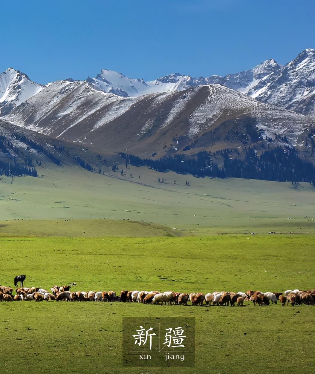
As the Xinjiang people sang in the lyrics, "We are a good place in Xinjiang, the Tianshan Mountains are good pastures in the north and south, and the Gobi beach has become a good field." "In the eyes of Xinjiang people, tianshan is like a father mountain.
In this mountain range, which is about 2,500 kilometers long, more than 250 kilometers wide, and has an average altitude of more than 5,000 meters, the snow melts from the mountains, forming the main source of many major rivers in Xinjiang.
Xinjiang rivers. Image source: Figureworm creative
As one of the seven major mountain systems in the world, the Tianshan Mountains, with their huge body, have resisted the cold currents in the northern Siberian region to the south, and also prevented the desert hot winds in the southern Tarim Basin from invading the north, making the climate between the south and north of the Tianshan Mountains quite different.
In the northern foothills of the Tianshan Mountains, because the cold front can no longer continue south, the summer is cool, and the winter is severely cold. As the elevation rises, the landscape also changes from mountain grasslands, mountain meadow grasslands, coniferous forests, and alpine grasslands to alpine glaciers that do not cover snow all year round.
The northern foothills of the Tianshan Mountains. Image source: Figureworm creative
On the other side of the Tianshan Mountains, due to the fact that there is always no cold front to supplement, the summer is unusually hot, and the winter is relatively warm, and the landscape is diametrically opposite to the northern foothills.
Southern foothills of the Tianshan Mountains. Image source: Figureworm creative
In traditional Chinese myths and legends, the Tianchi of tianshan is the "yaochi" where the queen mother of the west invites the immortals to hold a peach festival. It is said that King Mu of Zhou of Western Zhou also visited the Queen Mother of the West here and spread a good story.
The Tang Dynasty poet Li Shangyin also wrote a poem praising: "Yaochi Amu's window is open, and the yellow bamboo song is moving and mourning." Eight Jun traveled thirty thousand miles a day, and King Mu did not come back. ”
Tianshan Tianchi. Image source: Photo Network
Compared with the mystery of the Tianshan Mountains, Kunlun Mountain, another sacred mountain located in the south of Xinjiang, seems to be more grounded.
In the Chinese Taoist cultural system, Kunlun Mountain is known as the "ancestor of ten thousand mountains" and the "first sacred mountain" in China. Taoism believes that Kunlun Mountain is the place where the Jade Emperor lived on earth, and it is also the hometown of the gods.
Kunlun Mountain. Image source: Figureworm creative
As one of the main mountain ranges in southern Xinjiang, Kunlun Mountain was recorded as early as the "Classic of Mountains and Seas" in the pre-Qin period: "Kunlun's void, eight hundred miles square, high wanling." ”
Compared with the height of the Tianshan Mountain, the height of the Kunlun Mountain is really high. Known as the "Three Heroes of Kunlun", Muztag Peak, Gonggel Peak and Gonggel Jiubie Peak have an average altitude of more than 7,000 meters, which is as proud as optimus prime. The main peak of the Karakoram Mountains, Chogory Peak, reaches 8611 meters above sea level, second only to Mount Everest, the second highest mountain in the world.
Tibetan antelope at the foot of Kunlun Snow Mountain. Image source: Figureworm creative
Sandwiched between the Kunlun Mountains and the Tianshan Mountains, the Tarim Basin is the largest basin in Chinese mainland. "Tarim" means river confluence in Uyghur. In the past, the Kashgar River and the Weigan River in the basin once joined the Tarim River.
However, due to the influence of the Kunlun Mountains and the Qinghai-Tibet Plateau and the Himalayas in the south, the Indian Ocean monsoon with marine moisture cannot cross the barrier to reach the Tarim Basin, resulting in sparse rainfall and arid climate here all year round. Due to the increasing use of water for agricultural irrigation, both rivers have now been cut off.
Taklamakan Desert. Image source: Figureworm creative
Although the natural environment of the Tarim Basin is harsh, nature has also blessed the Tarim Basin with rich oil and gas resources, making it the most important energy and economic center in western China and playing an important role in the node of the "West-to-East Gas Transmission Project".
Tarim Oilfield. Image source: Figureworm creative
Hotan, in the southwest corner of the Tarim Basin, has been china's famous jade town since ancient times. With its crystalline warmth and solidity, Hetian jade has always been known as "one of the four famous jades in China". In the hierarchy of Hetian jade, mutton fat white jade is the best, and it is also the treasure in the palm of many royal nobles in ancient times.
Xinjiang Hotan has beautiful jade and jujube. Xinjiang Hetian sun jujube. Image source: Figureworm creative
Compared with the desolate scenery of the Kunlun Mountains, the natural environment of the Altai Mountains is obviously superior. In Mongolian, "Altai" means "gold". The Altai Mountains in the north of Xinjiang, the lush green and majestic scenery is of course a rare natural gold.
Due to the infiltration of the Irtysh River, the deeper you go into the Altai Mountains, the more you can enjoy the grasslands and forest greenery that are very different from southern Xinjiang. Kanas, Burzin, Kalamaili Hill and many other landscapes and beautiful nature reserves are the masterpieces here.
Xinjiang Altay Kanas Scenic Area. Kanas Lake in autumn. Image source: Figureworm creative
Compared with the beauty and richness of the Altai Mountains, the Junggar Basin, sandwiched between the Tianshan Mountains and the Altai Mountains, remains a bit cold. In this land, there is a kind of granite wind erosion "stone egg landform". Because the surface of the rock is weathered by sunlight, running water, and air, the edges and corners are gradually smoothed out to form a huge rounded stone.
<h1 class="pgc-h-arrow-right" data-track="998" >2.1 miles away</h1>
Historically, the Xinjiang region has long been closely engaged in exchanges and integration with various ethnic groups in other provinces in the Central Plains.
More than 2,000 years ago during the reign of Emperor Wu of the Han Dynasty, the ancestors of Xinjiang extended from the Kunlun Mountains and the Hotan area from near and far to the east and west wings, transporting the Hetian Jade, which was abundant in the Kunlun Mountains, to distant places.
The route passes east through Gansu, Ningxia, shanxi, and henan; to the west, it passes through Uzbekistan and reaches the Eurasian countries along the Mediterranean coast. Since then, the western trade opened by Wada Miyu has flourished for a long time. On this road, King Mu of Zhou began his journey around the world.
Zhang Qian also left Chang'an according to the direction of the jade road and embarked on a journey to find his ally in the vast desert, the Great Moon Clan.
Caravans in the Xinjiang desert. Image source: Figureworm creative
The Western Civilization and the Central Plains Civilization have undergone fierce cultural collision and integration on this road. The Central Plains is exquisitely bronzed and exquisitely crafted silk fabrics.
As the caravans traveling between the two places approached the western region, they went far away. Artistic masterpieces and jade from the Western culture also flowed into the hands of the ancient royal family and nobles, affecting the process of cultural development in the Central Plains.
Women in Xinjiang are threading needles. Image source: Figureworm creative
Although Zhang Qian's visit failed to broker an alliance between the Great Han Dynasty and the Great Moon Clan, with his exploration, the Han Dynasty paid more attention to this great northwest, which was thousands of miles away.
Since Emperor Xuan of Han, the Han Dynasty has set up the Western Regions Capital Protectorate in the area of present-day Luntai in Xinjiang, to unify the jurisdiction and maintenance of commercial exchanges on the Silk Road, coordinate contradictions and disputes between countries in the Western Regions, stop the intrusion of foreign forces, and guard the peace and tranquility of the Silk Road.
In the second year of the Western Han Dynasty (60 BC), the central government established the Western Regions Capital Protectorate and ruled the city of Wulei. Its establishment marks the formal incorporation of Xinjiang into China's territory. Archaeologists have calculated from the relative distances between the cities recorded in the Book of Han that Wulei City may have been located near present-day Luntai County. This is exactly the same as the location of the ancient city of Kuiyuk Xiehaier and the ancient city of Zhuorkut, which ancient city is the specific Wulei City? Only waiting for more informative archaeological discoveries can be conclusively proven. The picture shows the ancient city of Kuiyuke Xiehaier in Luntai County, Xinjiang. Source: Xinjiang Institute of Cultural Relics and Archaeology
In the ensuing alternation between the two Han Dynasties, the Western Regions Capital Protectorate was abolished, and the Xiongnu once again took advantage of the void to disturb the peace and stability of the Western Regions, but the countries of the Western Regions never gave up their faith in the Great Han Dynasty and demanded that the Western Regions Capital Protectorate return to rule the Western Regions.
In order to continue to maintain and strengthen the connection between the Central Plains and the Western Regions, under the coordination of the second emperor of the Eastern Han Dynasty, Emperor Ming of the Eastern Han Dynasty, the Han Dynasty attacked the Xiongnu in four ways. In this expedition, Ban Chao, an outstanding diplomat who influenced later generations, embarked on the journey of envoys to the Western Regions for the first time.
Statue of Ban Chao. Image source: Figureworm creative
In the contest with the Xiongnu for the countries of the Western Regions, Ban Chao relied only on the weakness of the 36 soldiers around him to persuade the states of Shanshan, Jimi, Shache, Shule, Yueshi, Wusun, and Kangju to submit to the Han Dynasty. The history book evaluates: "Sixty-five years since the Western Regions have been extinguished, but they have been restored. ”
With the efforts of Ban Chao for decades, the countries of the Western Regions have restored their worship and worship of the Han Dynasty and continued their past glory, and this tradition has also deeply affected the relationship between the Later Central Plains Dynasty and the Western Regions. According to the Book of Wei, the Zizhi Tongjian and other records,
Since the 5th century AD, Guizi, Shule, Wusun, Shanshan, Yanqi, Cheshi, etc. in the Western Regions have paid tribute to the Northern Wei Dynasty, the northern regime of the Central Plains Dynasty at that time. In return, the Northern Wei also sent a number of official missions to the Western Regions to strengthen trade cooperation and friendly exchanges between the two places.
The ancient city of Gaochang. Image source: Figureworm creative
By the 7th century, with the advent of the Tang Dynasty, this tributary bond became more frequent. Tang Taizong once said: "The king regards the four seas as one family, and within the feudal domain, all are pure sons." ”
During this period, the Tang Dynasty monk Xuanzang set out from Chang'an, crossed the desert, turned over the Tianshan Mountains, and entered Central Asia, traveling all the way to today's Afghanistan, Pakistan, India and other places. After 19 years of westward travel, the Tang monk returned to Chang'an and left behind a book, "Records of the Western Regions of the Tang Dynasty". Later, combined with what he saw and heard during his journey to the west, coupled with artistic creation,
Wu Cheng'en's "Journey to the West" was born. Under the inspiration of the Sheng Tang Dynasty, all parts of the Western Regions have launched a trip of tribute in full swing. In order to facilitate the pilgrimage to the Tang Dynasty, the Uighur ancestors of today's Uyghurs requested the construction of a passage from the desert to Chang'an, and gave the road a name: The Samtian Khan Road.
Qianling Sixty-one Statues of The Emperor. Image source: Figureworm creative
Today, the statue of the Sixty-one Emperors standing in the Qianling Tomb of Emperor Gaozong of Tang dynasty wears a round neck and tight sleeves, and the placket is to the left, which is different from the han people in the Central Plains, which usually has a right and wide sleeves. This detail reveals their ethnic minority identity from the Western Regions. Among the 36 stone statues that have been identified so far, there are Persian princes, Western Turk chiefs, Uighur chiefs, Khotanese kings, Guizi kings, Tocharian kings and other western nobles.
From this, we can also see the respect and worship of the Western Regions for the Tang Dynasty. Since the Tang Dynasty, this connection has remained close and frequent, although due to many factors such as war, the Central Plains Dynasty has once again fallen into a situation of multi-regime coexistence. The Western Regions were also in chaos due to the westward advance of the Arab Empire in Central Asia, but the Western Regions never gave up their ties with the Central Plains.
Even though there were many difficulties, they still tried their best to reach the Central Plains. With the assistance of the Liao regime in the northern central plains, the tributes of the western regions and the central plains rose to the state system. At that time, the Qarakhanid Dynasty, which represented the Western Regions, paid tribute to the Central Plains every three years.
Qianling scenery. Image source: Figureworm creative
After the fall of the Liao Dynasty, Yelü Dashi, the eighth grandson of the founder of the Liao Dynasty, Yelü Abaoji, led the remaining 200 Khitan warriors to break through many difficulties and enter the western region, once again continuing the glorious culture of the Liao Dynasty in the hinterland of Central Asia.
It was not until the iron hooves of the Mongols swept across Eurasia that the whole process of cultural integration between the Western Regions and the Central Plains was completed. In the 17th century, due to the alternation of the Ming and Qing dynasties, the Dzungars of the Mongol tribe of Weirat controlled the north and south of the Tianshan Mountains.
The leaders of the Dzungar clan sent envoys to the Qing government every two years, and the Qing government repeatedly gave a large amount of money to the Dzungars, but within the Dzungar aristocratic clique, there were still some people who insisted on a rebellious position. In view of this, the Kangxi Emperor of the Qing Dynasty resolutely marched and completely conquered the Dzungar Khanate.
With the joint efforts of the three emperors of Kang, Yong, and Qian, the northwest region was finally effectively controlled, and the western region and the central plains became inseparable.
The ruins of the ancient city of Dzungar. Image source: Figureworm creative
However, with the decay and decline of the Qing government, some feudal landlords and religious upper-class elements began to dominate one side again. Since the 1830s, the western region has been invaded by zhang ge, Agubai and other forces, and the northwest border defense has encountered unprecedented pressure. At this time of crisis, two different voices arose within the imperial court at that time.
Regarding the going or staying in the Western Regions, the ministers expressed different attitudes one after another. At the repeated insistence of Zuo Zongtang, the governor of Shaanxi and Gansu, the Qing government finally decided to march west and quell the civil unrest.
Urumqi Xinjiang International Grand Bazaar. Bazaar means bazaar, and there is a local saying that bazaar can be found in addition to parents. Image source: Figureworm creative
In 1876, Zuo Zongtang sent troops to the Western Regions in Gansu. In the campaign to retake The city of Dihua (present-day Urumqi), the Qing army set up cannons on the mountain and beat up the Agubai rebels, causing the opposite side to collapse and flee in a hurry.
After this victory, in order to facilitate the jurisdiction of the western region, the Qing government officially announced to the world in 1884 that it would establish a province in the Xinjiang region.
<h1 class="pgc-h-arrow-right" data-track="998" >3. Xinjiang is so big that it can't be stewed in one pot</h1>
In the process of thousands of years of integration between Xinjiang and the Central Plains, there have also been subtle changes in religion, culture, eating habits, and customs. Today's Xinjiang has been officially named the Xinjiang Uyghur Autonomous Region. The so-called "Uyghur" means united and friendly.
Today, in Xinjiang, there are nearly 50 ethnic groups living in Xinjiang, including Uyghurs, Kazakhs, Hui, Xibo, and Han.
Children in the old town of Kashgar. Image source: Figureworm creative
As one of the most important Muslim settlements in China, the Uyghurs living in this land have traditional festivals such as Eid al-Adha and Meat Festival. Eid al-Adha, a festival of sacrifice and sacrifice.
According to tradition, pilgrims are required to slaughter animals on this day. Eid al-Adha is the largest muslim worship of the year. On this day, all adult men are required to pray at the nearest mosque, which is called a "gathering ceremony". After attending the ceremony, families need to go to the cemetery to pray and remember their deceased ancestors.
After the ceremony, the mosque's musicians also beat the nagra (iron shell drum) and blow the sunai (唢呐) to express the festive mood.
In the summer, Xinjiang Urumqi Xingguang Night Market opened. Image source: Figureworm creative
Every year around March 22, in the Xinjiang region, Kazakhs begin to celebrate their own "Spring Festival" - The Nauruz Festival.
On this day, the Kazakh people travel in full costume, walking in groups of streets and alleys, and paying respects to each other. Similar to the traditional Han Chinese New Year, on this day people pay attention to "auspicious wishes", according to the custom, they will sacrifice the head of the first sheep slaughtered in the New Year to the oldest elderly in the family to pray for the health and longevity of the elderly, and the elderly will also thank the devotees with various blessings.
Among these grand festivals, the Turpan Grape Festival is probably the most well-known to the Chinese people. In Xinjiang, every August is the season when the grapes ripen. Grapes are one of the most representative characteristic fruits in Xinjiang. When people celebrate the harvest, they always express their joy in the form of a festival.
Xinjiang shade room, drying raisins. Image source: Figureworm creative
Due to the special geographical environment of the Turpan region, the summer weather is quite hot, and it is known as the "Fire Continent". The temperature difference between day and night allows the plant sugar to accumulate, resulting in the excellent quality of the grapes produced. In terms of diet, after two thousand years of the influence of the Silk Road, the diet structure of Xinjiang people has also been greatly improved.
In the past, the people of Xinjiang, who were deeply influenced by nomadic culture, mainly ate meat and dairy products, and rarely ate vegetables, but after exchanges and integration with the Han nationality, vegetables have gradually added a richer food experience on the basis of "eating meat and drinking cheese" in Xinjiang. Because the Xinjiang region is located inland, there is drought and little rainfall.
Animal husbandry has greater advantages over other agriculture. Therefore, in the diet of Xinjiang people, it is still mainly cattle, sheep and chickens.
Xinjiang large plate of chicken. Image source: Figureworm creative
The lamb is cut into pieces, skewered with red willow branches, grilled on a charcoal fire, and sprinkled with chili noodles and cumin noodles, which is a delicious feast for foodies.
However, if we talk about the food that Xinjiang people love the most, "naan" should be on the list. In Xinjiang, the bun, also known as Amaik, is a product of more than 2,000 years of food culture, and is also known as the poplar tree in the food industry. Like the poplar tree, it has the characteristics of being hidden for a long time.
Made from flour, naan is both a traditional dim sum and a staple food in Xinjiang. People in Xinjiang even believe that "it is better to have no meat for a day than to be without bread for half a day."
Xinjiang naan. Image source: Figureworm creative
Rice is more like a snack in Xinjiang's diet system. In Xinjiang, pilaf is a traditional specialty. This rice is made with lamb, carrots, onions, clear oil, mutton fat and rice as the main ingredients, added water and salt, and simmered over low heat, and is said to have considerable therapeutic effects.
Xinjiang hand pilaf. Image source: Figureworm creative
As a specialty of Xinjiang, the famous roasted whole lamb in the country is actually from the Kyrgyz ethnic group, and it is only grilled on the spot when the most grand festivals are celebrated, or when the most distinguished guests visit, and it is the most "hard" dish in Xinjiang cuisine.
Xinjiang roasted whole lamb. Image source: Figureworm creative
Roasted whole lamb is very expensive, after roasting can not be served immediately, to tie a red head knot, with celery or coriander in the mouth, the shape is like a live sheep lying down to graze, and then put on the table, for guests to cut and taste. The roasted whole lamb has a bright color, crispy skin, tender meat, rich flavor, and when eaten, it is sliced and eaten with salt.
<h1 class="pgc-h-arrow-right" data-track="998" >4. Xinjiang, new weather</h1>
In addition to the food and beauty, Xinjiang's transportation is also a highlight. Over the past 2,000 years on the Silk Road, camels and horses have been the main tools for Xinjiang people to travel. Today, in places like Urumqi, the capital of Xinjiang, the innovation of transportation has made major changes to the way people travel.
Since the reform and opening up, Xinjiang began construction in the 1980s to build the first high-grade highway ever built in northwest China, the Wuchang Highway. From Urumqi, xinjiang people feel the progress of modern industry.
Since then, the construction of highways in Xinjiang has entered a new stage, with a network of highways intertwined, large buses, small passenger cars, private cars, in less than 30 years, Xinjiang people have completely changed the past thousand years of traffic travel traditions.
Xinjiang Guozigou Bridge. Image source: Figureworm creative
By the end of 2020, the total length of expressways in Xinjiang has exceeded 5,500 kilometers, and the total length of local highways has reached a staggering 200,000 kilometers. In addition, the housing environment of Xinjiang people has also changed from the previous nest to a bright two-bedroom and three-bedroom apartment, combined with the living habits of Xinjiang people, equipped with a basement, which can store cabbage and turnips for winter.
After entering the 21st century, Xinjiang is lined with high-rise buildings and the weather has been renewed.
Aerial photo of Bagua City in Xinjiang. Image source: Figureworm creative
As an important petroleum and petrochemical production base in the country, Karamay in Xinjiang is the "leader" in this construction trend. In the past, due to the erosion of intermittent torrents and the long-term effect of strong wind erosion, the Karamay area was mostly dry and cracked loess, with no grass, and the surrounding area was dead and silent, which was creepy and creepy.
Karamay Oilfield. Image source: Figureworm creative
Today, Karamay has gradually become a famous oil city in China with its unique oil reserve resources and a prosperous chemical industry.
cotton. Image source: Figureworm creative
Xinjiang lavender. Every June, lavender begins to bloom. Before the 1960s, China's lavender spices were all imported. In order to change this situation, people have carried out trials in several provinces. After waiting for 6 years, only the lavender cultivation of Ili was successful. Today, 95% of China's lavender comes from here. Image source: Figureworm creative
In the past, with the camel caravans walking on the Silk Road, the Western Regions opened the way to the civilization of the Central Plains. Today, Xinjiang, which is constantly changing in food, clothing, housing, and transportation, will surely shine again in the rejuvenated China.
Bayinbrook Grassland, Xinjiang. Image source: Figureworm creative
References: Traveling through The Editorial Office of China: Xinjiang, China Tourism Publishing House, 2007 Lou Wanghao: Xinjiang Cuisine, Xinjiang People's Publishing House, 2006 Wanghao: Xinjiang Folk Customs, Xinjiang People's Publishing House, 1996