Tonga, short for Kingdom of Tonga, is an archipelagic country located in the western South Pacific Ocean, about 650 kilometers west of Fiji and about 1770 kilometers southwest of New Zealand. Tonga consists of a total of 173 islands, most of which are coral islands, of which 36 are inhabited, with a total land area of about 747 square kilometers, which is one of the smallest countries in the world, and the total population of Tonga is about 110,000 people.
The "Tidal Vent" on Tongatapu Island
The main islands in the Tonga archipelago include Tongatapu, Eva, Tofua, Afo, Lathai, Kapa and Hon A. Among them, the largest island in Tonga is "Tongatapu Island", located in the southern part of the Tonga Archipelago, with an area of about 257 square kilometers, accounting for about one-third of the total area of the country. Located on the island of Tonga Tab, which is home to 70% of the country's population, Tonga's capital, Nuku'alofa, is the economic and transport centre of Tonga.

Location map of the Kingdom of Tonga
The latitude and longitude of Tongatapu Island is about 21° south latitude and 175° west longitude, located in the tropics, belongs to the tropical oceanic climate, the annual precipitation is as high as 1700 mm or more, the natural vegetation distributed on the island is mainly tropical rainforest, and coconuts and bananas are mainly grown in agriculture. Tongatapu Island is a coral island formed by the continuous accumulation of exoskeletons of marine coral insects, the rocks distributed on the island are mainly limestone, the average altitude of the island is about 10 meters, and the terrain is very low.
Map of the Tonga Islands
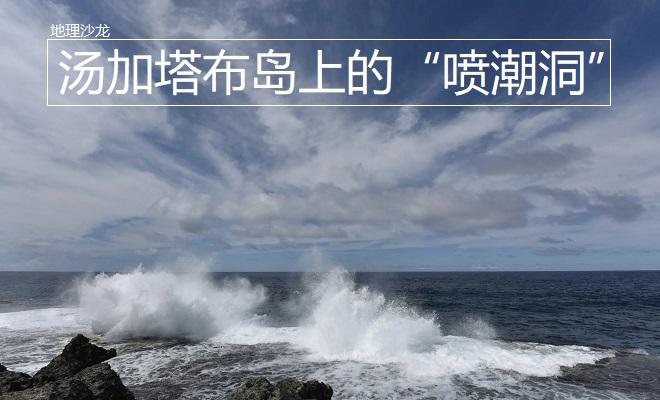
There is a strange natural phenomenon on Tongatapu Island, whenever the tide rises, on the southern coast of Tongatapu Island, the tide will gush out along the thousands of large and small caves in the reef, forming tens of meters of water column, blooming in the air, like a fountain, forming a strange "tidal cave" landscape. Why is there such a peculiar "tidal cave" on the southern shore of Tongatapu Island?
Tidal spray holes
Obviously, to form a water spray landscape, first of all, there must be fissures and holes in the rocks on the shore, Tongatapu Island is a coral island, the island is widely covered with soluble rocks, under the erosion of external weathering, a large number of cave fissures have been formed, providing a basis for the phenomenon of jetting. Secondly, at high tide, the tide is more powerful, so that the tide quickly pours into the cave and gushes out from the other end. Since Tongatapu Island is a coral island, there are more coral reefs around the island, while there are fewer coral reefs in the south side of the island, which is less resistant to tides.
Satellite view of Tongatapu Island
In addition, from the perspective of the pressure belt and wind belt, Tongatapu Island is affected by the southeast trade winds, and the sea south side of the island is located on the windward side of the southeast trade wind. At high tide, the southeast trade wind will blow the sea water to the shore, increasing the high tide level and enhancing the power of the tide, thus forming a tidal spray landscape. The large number of caves and fissures on Tongatapu Island will not only cause the sea to pour in at high tide, but also the surface fresh water that will flow away from the caves, thus exacerbating the water shortage on the island.
Aerial photography of Tongatapu Island