Author: Bin Ge
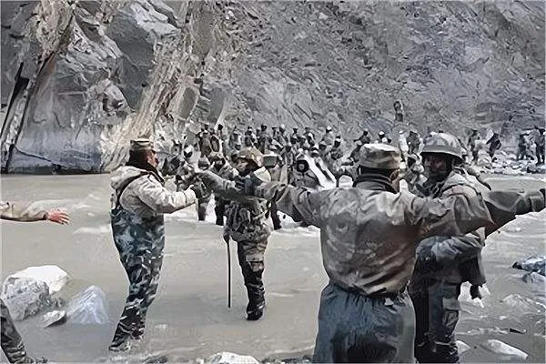
In February last year, the domestic media focused on the casualties of our side in the 2020 China-India border conflict. In June 2020, our border troops lost at least 20 Indian troops at the cost of four casualties and one serious injury in the Galwan Valley area of the China-India border.
By August, China and India had almost lost fire in the Pangong Lake area. Unlike southern Tibet, the western section of the Sino-Indian border has long been relatively calm. But in fact, the Galwan Valley and Pangong Lake are two important control nodes in the struggle between the mainland and India on the western front; it can be said that if our army firmly controls these two places, india will be in a passive position in the entire western border line.
"Disputed areas" on the China-India border
Many people's understanding of the Sino-Indian border dispute is focused on the eastern sector, where the contradiction between the two sides is very simple; that is, we believe that the Sino-Indian border should follow the traditional customary line, while India has occupied the southern Tibet region according to the illegal "McMahon Line". China and India also have 2,000 kilometers of land in the middle section of the border, which is actually controlled by the Indian army.
The current western boundary is about 650 kilometers long and is under the jurisdiction of the Ali region of Tibet and the Hotan region of Xinjiang respectively. The disputed Aksai Chin region here covers an area of more than 30,000 square kilometers, and the rest is controlled by China except for Barigas. But according to India, Aksai Chin should be India's "inherent territory"; then, where did the absurd idea of Indians come from?
There is no clear demarcation between the historical local government of Tibet and the fragmented India, which is also an important reason why India can create friction on the Sino-Indian border.

The Ladakh region in present-day eastern Kashmir was historically also under the jurisdiction of the local government of Tibet; it was occupied by the Sikh kingdom of India in 1835. The British colonists not only "took over" Ladakh during their conquest of all of India, but also concocted the so-called "Johnson Line" in 1865, and the Aksayn region east of Ladakh was also included in British India. Although successive Chinese governments have not recognized the "Johnson Line," Indians have used it as a basis for believing that Aksai Chin is Indian territory.
Unlike southern Tibet, however, India has never actually controlled Aksai Chin in its history. In 1962, the People's Liberation Army (PLA) expelled all the Indian strongholds that had invaded Aksai Chin and once penetrated deep into the Ladakh region. However, because of logistical difficulties, it can only retreat, so the current china-India western border actual control line has been formed, rather than the national border that has been determined.
The Galwan River Valley is condescending, making the Indian army sigh
Many people have a lot of criticism of our army's victory in the 1962 Sino-Indian War and its retreat. It was believed that our army should have done its part in one battle and completely recovered all the disputed land. However, the topography of the Sino-Indian border and the national strength of China at that time determined that our side could only carry out a punitive war of limited scale. Therefore, although the mainland announced a ceasefire and withdrawal, the PLA firmly controlled some key points in southern Tibet and the Aksai Chin region.
The Galwan Valley, where bloodshed broke out in June 2020, was an important camp chosen by our army after the end of the self-defense counterattack. Although India has until now coveted the Aksai Chin region, the terrain on the Ladakh side it controls is also very harsh. Unless you can cross the Karakoram Mountains, you can only enter AksaiChin through the river valley.
The Galwan Valley is an important gateway for India to penetrate deep into Aksai Chin. Although the overall terrain is higher, the river valley is relatively flat, and the altitude is about 500 meters lower than on both sides. Although the Galwan River is only 83 kilometers long, the current is very rapid and there are deep pools of tens of meters under the water. Therefore, once the personnel of both sides fall into the water in the conflict, it is not easy to survive.
Galwan Valley and Pangong Lake area
The Galwan River joins the Shijok River in the area of the current China-India Line of Actual Control, and the Shijok River eventually joins the Indus River. In the vicinity, only the present river valley beaches are suitable for garrisoning, which is why our army has firmly controlled it since 1962.
In the view of the Indian army, as long as the Chinese set up camps in the Galwan Valley, it will be difficult for them to do anything in the nearby areas; this is also an important reason for the conflict between the two sides.
On the other hand, if the Indian army abandons the Galwan Valley, they can follow the Shiyok Valley around the Daodypsin Plain and then invade Aksai Chin. However, due to the condescending area of the Galwan River Valley, all the movements of the Indian army in the Shyok Valley can be seen at a glance. Therefore, if India wants to move from the direction of the Depsang Plain, its troop movement and logistical support are under the watchful eyes of the Chinese troops in the Galwan Valley. Therefore, the Indian army can only look at the mountains and sigh in the Galwan Valley area, and cannot exert any advantages.
Topography of the Pangong Lake area
Pangong Lake is salty in the east and salty in the west, which is conducive to the garrison of our army
The Indian army did not take advantage of the Galwan Valley, so it moved the battlefield to the Pangong Lake area more than 100 kilometers away. Pangong Lake, which means "long-necked swan" in Tibetan, is located about 12 kilometers northwest of the county seat of Ritu County in the Ali region of the Tibet Autonomous Region. Pangong Lake is also the boundary between Aksai Chin and Ladakh, which means that this area originally belonged to Chinese territory.
China's garrison at Pangong Lake is a water squadron of a division of the Ali Military Sub-district, which is known as the "National Gate Fleet on the Top of the Mountain" and is called the "West Sea Fleet" by some media. The squadron was formerly known as the Water Transport Squadron of the Zhoushan Islands of the East China Sea Fleet, and was transferred to Pangong Lake after the Sino-Indian War in 1962. After arriving at Pangong Lake, they quickly ran away the Indian patrol boats, thus forming the current line of actual control.
Our army patrols the trail in the Pangong Lake area
Pangong Lake is a typical highland lake, limited by the terrain in an east-west narrow direction. Among them, 413 square kilometers in China and 191 square kilometers in India-controlled areas. In the eastern part controlled by China, a large amount of high mountain meltwater was injected into fresh water, which not only met the needs of the local garrison but also developed tourism by the lake. The western part controlled by India has become a saltwater lake because it is very difficult to exchange water bodies with the eastern water body.
Under the harsh temperature and illumination conditions of the Qinghai-Tibet Plateau, there is almost no grass on the west side; the Indian troops stationed nearby even need to supply drinking water from the rear, and naturally it is impossible to deploy a military force comparable to our side.
The contest between China and India in the Pangong Lake area is not simply the army and logistical support capabilities, but also the water equipment of the two sides. At present, the "West Sea Fleet" is equipped with 22 advanced Type 928B high-speed patrol boats, each of which can carry 5 to 7 soldiers, and the boats are equipped with large-caliber machine guns. India has also purchased high-speed patrol boats from the United States, but overall we have the upper hand.
China is doing its best to maintain the status quo
The fact that China and India clashed in the Galwan Valley and Pangong Lake area also shows the cleverness of the Chinese military at that time. Neither Aksai Chin nor Ladakh is suitable for normal human production activities, and the army, which consumes a lot of logistical resources, can only be stationed in a few areas with relatively good conditions. If you want to not be dragged down by the enemy and maintain the initiative, you can only occupy a strong control point to achieve "half the effort".
My "West Sea Fleet" on patrol
Although there are always people who want to devote themselves to a battle to completely solve the Sino-Indian border problem. Unfortunately, whether in southern Tibet or Ladakh, the People's Liberation Army is in a dilemma that cannot be said. For example, in 1962, my 30,000 border troops easily defeated the invading Indian army. But further into the hinterland of India, India can use its huge population base to pull out a million troops to engage in a war of attrition with our army. In this way, it became an enlarged version of the "Battle of the Golden Gate," and our army had no chance of winning at all.
Since a war of this magnitude cannot solve the fundamental problem, it is even more difficult to gain by relying on small-scale conflicts. Therefore, in 1962, our side took the initiative to withdraw from southern Tibet, but firmly controlled all the commanding heights and cut off the idea of the Indian army advancing north. The western border, which only needs to hold the Galwan Valley and pangong Lake area, will allow India to not invade Aksai Chin, but instead fear that the PLA will threaten New Delhi 400 kilometers away.
Beautiful Pangong Lake
It is now also clear to the Indian government that its attempt to seize Aksai Chin by military means is unrealistic. However, because Prime Minister Modi and the newly ascended Chief of Defense Staff Rawat have been advocating "great Indian nationalism" for many years, some Indian military officers have the sinister purpose of getting rich by touching porcelain at the border; they will provoke in the Galwan Valley and Pangong Lake areas, trying to change the line of actual control between the two sides through small-scale adventures.
Our army has already occupied the time, location and people in these two places at the same time, and whether it is a small-scale provocation or a large-scale attack by the Indian army, it can be easily cracked. As long as the Indian army is unable to make a difference on the Sino-Indian border, our army can concentrate more resources on the more important eastern direction, which is in the overall interests of the mainland's national defense at present.