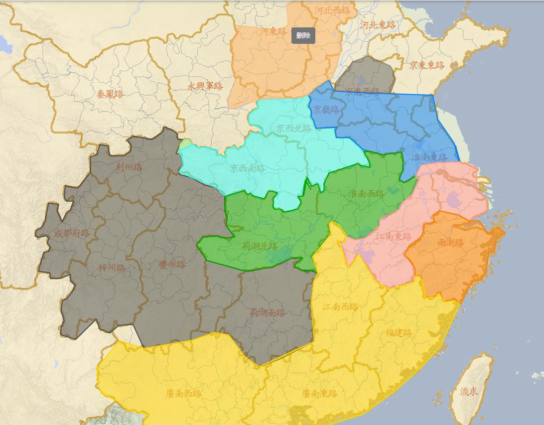
Recently, in sorting out the control areas of various forces, I have basically reorganized the original work, which is really a lot of work. The comparison of place names alone took two days, and only the approximate location of the place names was aligned. Plus the novel is alternate history, and the Song Dynasty prototype on the map, many places do not match.
The clues to the dividing lines of the various forces are basically hidden in some small events. For example, the dividing line between black flag and Dai Mengwei's forces, I found some clues from the line from NingJi out of the southwest to roughly determine their dividing line.
Without further ado, the results of these two days will be counted.
roughly depicted, without detailed geographical names,
Black Flag's sphere of influence

Black Flag Forces
Key Locations:
Huaxia Core: Zhangcun (Jiazhou, now Leshan), Chengdu (where the government center is located)
Sphere of influence, Chengdu Road (Fifth Army), Zizhou Road (Fifth Army), Fuzhou Road, Lizhou Road (Hanzhong is controlled by the Seventh Army, other places are still the Fifth Army), Jinghu South Road (controlled by the Twenty-seventh Army led by Chen Fan), south of Jinghu North Road (Lan Huan Dong), northern Jingdong Road (the Seventeenth Army led by Zhu Biao and the Third Division of the Fifth Army led by Liu Chengzong, and controlled by luo Ye led by special regiments)
Most of the above is analyzed from some small clues in the original work, and the mountainous part can only be regarded as the sphere of influence.
Black Flag mainly controls the Chengdu Plain, as well as some mountainous cities. Lan Huan Dong I think it should be in the Chenzhou, Yuanzhou area of Jinghu North Road, which belongs to the Miao ethnic concentration area in western Hunan Province, and the central and southern part of Kuizhou Road is also a gathering place for ethnic minorities, and Chen Fan has gone to Chengdu several times, and it should be the south-central part of Kuizhou Road, which should be within the influence of Black Flag forces.
Chen Fan also captured Changsha, and the south road of Jinghu should be controlled by the Twenty-seventh Army.
Let's talk about ningji's deikawa line,
Zizhou crossed the Jiange Pavilion to Zhaohua (here there are two roads in and out of Shudi, one is the Golden Bull Road, which goes straight to the central and western Han Dynasty, and the other is to go east to Bazhong and then take the Micang Road. Ning Ji took the second road) from Zhaohua to Bazhong, and then crossed the Micang Mountain (as mentioned in the original work, crossing the Micang Mountain to Dai Mengwei's territory) After crossing the Micang Mountain, they came to Zhenba County, where Dai Mengwei's nephew was appointed as the county commander (the text also mentions a Mingtongyuan, which is the present-day Wanyuan City) In Zhenba County, the leader of the caravan was beheaded here. After that, it was time to go to Ankang.
Cao Silong's sphere of influence
This man's sphere of influence was not large, and it should be within the scope of today's Shiquan County. After all, he is the product of compromise between the parties.
Cao Silong forces
Dai Mengwei's sphere of influence
Jingxi Southwest Road, Jingbei Northwest Road
Dai Mengwei forces
Liu Guangshi's sphere of influence
Most of Jinghu North Road, Huainan West Road
The text mentions Tongshan, saying that this is Liu Guangshi's territory, and after this place, it is not.
Liu Guangshi forces
Zou Xu's sphere of influence
Gyeonggi Road, South of Jingdong Road, South of Jingdong East Road, Most of Huainan East Road
Jindi's sphere of influence
Most of Hedong Road (Taihang Mountain, Mainly Zhongtiao Mountain), Hebei West Road
Fairness Party's sphere of influence
Jiangnan East Road, north of Liangzhe Road
Fairness Party forces
Lin'an Wu, Iron Sphere of Influence
South-central Liangzhe Road
Lin'an Wu, iron force
Fuzhou Imperial Court's sphere of influence
Fuzhou imperial court power
The core range of direct control: southern Wenzhou to Quanzhou
Indirect Sphere of Influence, Fuzhou Road, Jiangnan West Road, Guangnan East Road, Guangnan West Road (speculation)
Here to explain, the Wenzhou imperial court and Lin'an Wu, the iron power dividing line, I call it the Yongjia line, in the original work, Zhou Junwu and his sister Zhou Pei mentioned this line when discussing sea trade, in confrontation with Lin'an, and this line mentioned "The power of lin'an small imperial court gathered in the area of Yongjia (present-day Wenzhou) north of Changxi (present-day Xiapu County, Fujian)"
The text also mentions that Jiangnan West Road and Guangzhou are giving blood transfusions to Fuzhou, so it is speculated that Jiangnan West Road and Guangnan East Road are still adhering to the orthodox status of Junwu, and Guangnan West Road can only guess, after all, there is no mention in the text
In addition to the goods delivered to Fuzhou, Lu Wenke mentioned that he was the son of the prefect of Hongzhou (Nanchang), and if the Fairness Party controlled Hongzhou, a landlord family like him should have been raided, and it was impossible to have spare money to travel the world, nor could he go back.
Many places may not take care of you If you find a clue to the door, you can bring it up, I will sort it out, and the map used this time is also drawn by hand, and it has not been done in detail.
I try to mark the location of some cities and important place names, this work is difficult to do, after all, it is only a novel, bananas can not do a very detailed study, especially some battles, I tried to comb the route, found that some places the error is still very large.
If I dig a pit for bananas like this, will I be scolded by him?