"The southern boundary is Huaishui, and the north reaches the Yinshan Great Wall", which is described in 1908 by the geographer Mr. Zhang Xiangwen in "New Writings of Geography", which refers to the first time he proposed the dividing line between southern and northern China, the Qinling-Huai River.
We have learned in geography textbooks that the Line of the Huai River in the Qinling Mountains is the boundary between the south and the north. China has 23 provinces, 5 autonomous regions, 4 municipalities directly under the central government, and 2 special administrative regions.
So do the provinces and regions have their own divisions between the south and the north? Do they have their own "Qinling-Huaihe" dividing line?
Today we are talking about the north-south dividing line between Hebei Province and the Beijing-Tianjin-Hebei region.
Xiong'an North and South - Yan and Zhao - Liao and Song
The term Yanzhao Dadi today refers to present-day Beijing, Tianjin, and Hebei, that is, the Beijing-Tianjin-Hebei region. In ancient times, the Yanguo or Yandi culture was centered on Beijing, and the Zhao guo and Zhaodi cultures were centered on Handan. The dividing line between Yan in the north and Zhao in the south and Yan and Zhao can be regarded as the "Qinling-Huai River" of Beijing-Tianjin-Hebei.
So, how do Yan and Zhao divide?
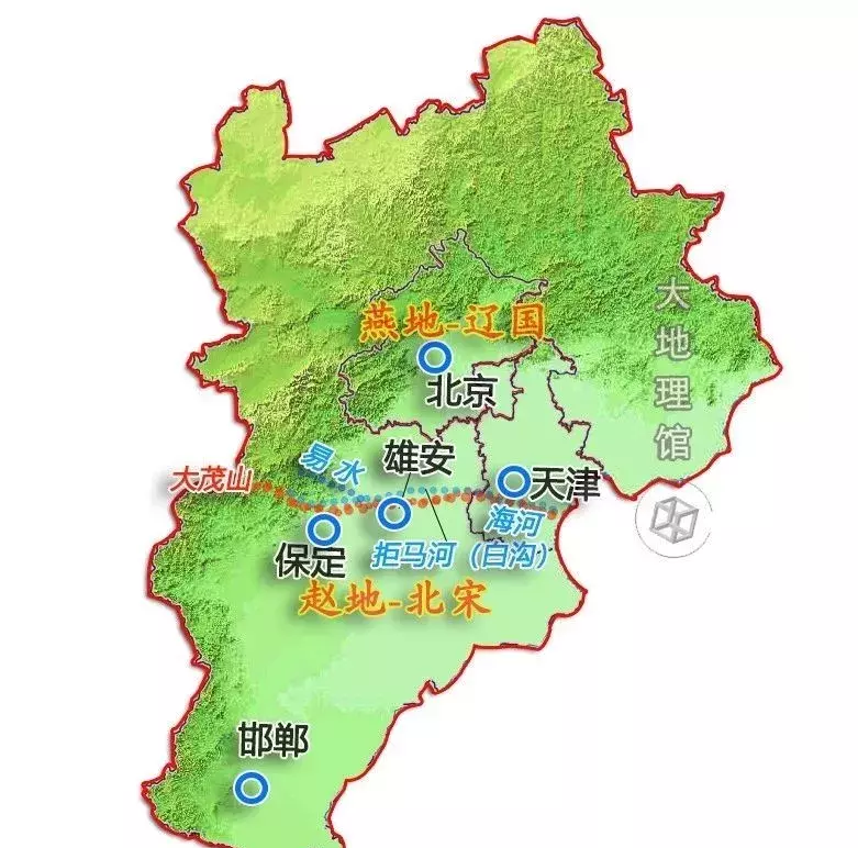
| schematic diagram of the north-south demarcation of Beijing-Tianjin-Hebei | Cartography: Grand Geographical Pavilion
Princely states often traded off each other, and it was difficult to determine a stable line. Jing Ke stabbed Qin Nandu Yishui to go beyond the border, and it can be seen that the boundary between the two countries is roughly near the south of Yishui, which belongs to present-day Baoding Yi County. There is a saying that the Yan-Zhao boundary is bounded by Baoding City, and there is a meteorite called the Yan-Zhao Boundary Stone in the ancient city.
The land of Yan and Zhao, in the Han, Wei and Jin Dynasties, the Northern Dynasty, the Sui and Tang Dynasties, and the Five Dynasties belonged to the same district, and after the Northern Song Dynasty separated again- the alliance of Liao and Song Yuanyuan, ushered in a long-term peace, the two sides demarcated the boundary of the Baigou River (the upper reaches of the Juma River), one of the tributaries of the HaiHe River, and opened a field on the river bank as a trading place.
Xiong'an New District is located near this boundary. This boundary is also roughly the boundary between Yan and Zhao.

Map of the Liao-Song confrontation
Liao-Song demarcation: Damao Mountain - Baigou River - Haihe River
The western starting point of this line is the Damao Mountain in the present-day Baoding area - it is worth mentioning that this mountain is actually the location of the earliest Beiyue Hengshan Mountain, which was transferred to present-day Hunyuan in Shanxi during the Ming Dynasty, where the Ancient Beiyue Temple is still preserved. The eastern foothills of Damao Mountain gave birth to the Baigou River, which is called juma River, Baigou River, Ziya River and Haihe River from upstream to downstream.
This is the "Qinling-Huai River" of Hebei and Beijing-Tianjin-Hebei, which demarcates the north and south here, namely Yandi and Zhaodi.