There are three representatives in geographic information technology, which we call "3S technology", which specifically include geographic information systems (GIS), remote sensing (RS) and global positioning systems (GPS, BDS and GLONASS, etc.). Remote sensing technology is through technical means, on the basis of not touching geographical things, to obtain geographic information, according to the height difference of remote sensing equipment, can be divided into aerospace remote sensing, aerial remote sensing and near-Earth remote sensing.
Traffic and settlement distribution in satellite photographs
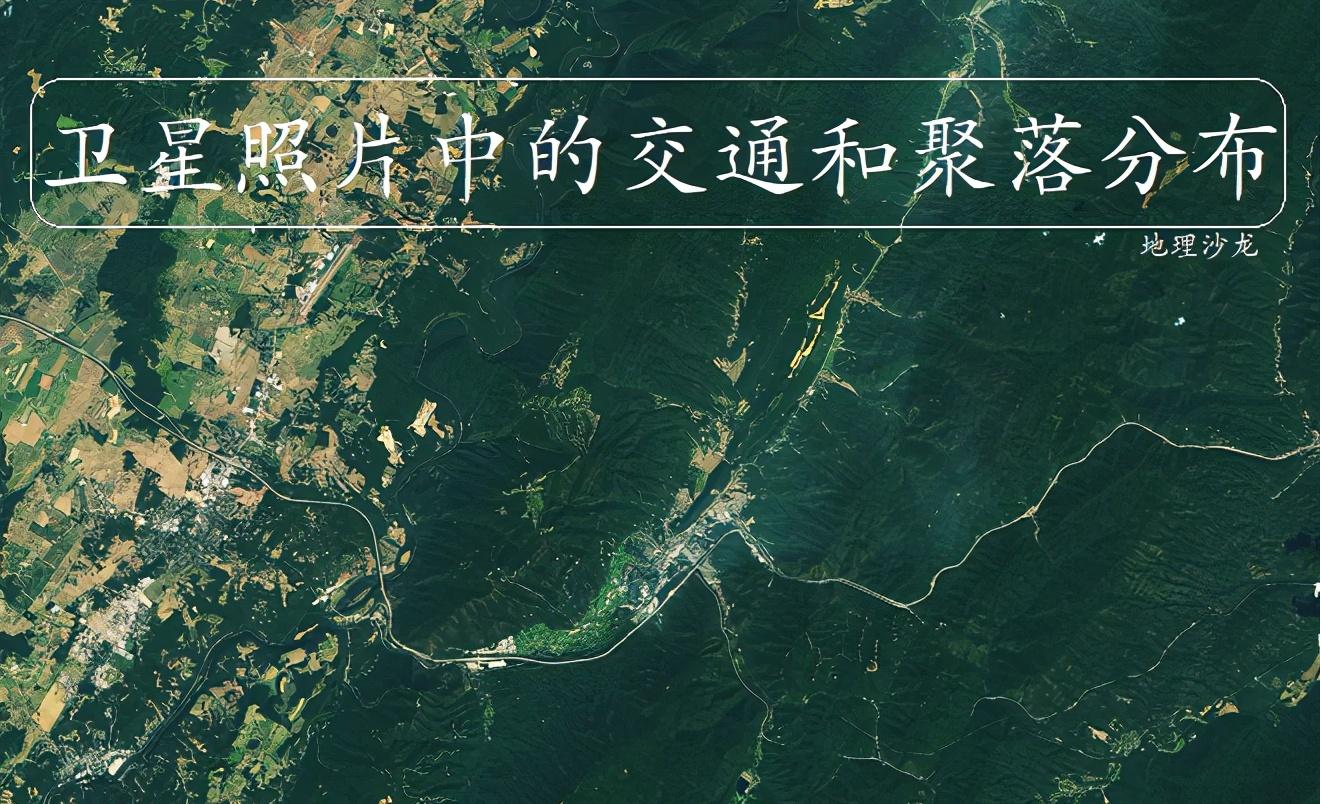
Remote sensing can obtain a large amount of surface information and plays an important role in resource census, disaster monitoring, agricultural yield estimation and so on. We can learn a lot of geographical knowledge by looking at remote sensing images, and today we will look at a satellite remote sensing photo to see the impact of terrain on traffic routes and settlement distribution. The photo was taken by Landsat 8 in 2019 and was taken in the Allegheny Mountains, part of the Appalachian Mountains in the eastern United States.

Satellite photo of the Appalachian Mountains region
The Appalachian Mountains are the most important mountain range in the eastern United States, running northeast-southwest, with a total length of more than 3,000 kilometers, a width of between 130 and 560 kilometers, and an average elevation of between 1,000 and 1,500 meters. We know that the terrain is an important factor affecting the selection and construction of traffic routes, and most of the area on the middle side of the satellite photo is a mountainous hilly terrain with a rough terrain, while the western side is a relatively flat plain or wide valley.
Traffic routes in the shape of a zigzag
As far as traffic is concerned, in the flat topographic distribution area, the number of traffic lines is usually larger, and the traffic lines are relatively straight and mostly in a network layout. In the rugged hilly and mountainous areas, the number of traffic routes is usually small, and the direction is limited by the terrain, and in the satellite photos we see that the main traffic routes in the eastern area are mostly distributed along the lower valleys, in a linear distribution. In the hilly and mountainous areas on the east side, due to the steep slope of some areas, the construction of traffic routes will mostly be in a "zigzag" layout, which can reduce the slope of traffic routes.
Flat area on the west side of the satellite photo
Terrain is an important influencing factor in settlement construction, and flat terrain is ideal for settlement construction, including terrain such as plains, plateaus and basins. In the western area of the satellite photo, the terrain is relatively flat, and the development of settlements in between is less limited by the terrain, and large-scale settlements can be developed, and the settlement form will mostly show a "reunion type".
Mountain settlement "White Sulfur Spring Town"
In the hilly and mountainous area on the east side of the photo, the situation is different, a large area of rugged hilly mountain land is not suitable for settlement construction, human beings in order to build settlements, can only find relatively flat areas, mostly choose in the valley area. Due to the limitations of the terrain, the settlement form in the mountainous area is mostly "banded" distribution, and the scale of the settlement is usually small. In the photo there is a "white sulfur spring town", located in a valley, distributed in a circular arc according to the mountain. Similar situations are also very common in China, such as Lanzhou, the capital city of Gansu Province, which is a settlement located in the Yellow River Valley, limited by the terrain on the north and south sides, and distributed in a striped manner.
Aerial view of Lanzhou City