Ye Weiqi
Ningde City is one of the northeastern coastal gateways of Fujian Province, and the main river in the area, Huotong Creek, runs through the whole territory from northwest to southeast. The meandering Huotong Creek originates from the hinterland of the mountains and flows into the sea through more than 100 kilometers. Where the stream passes, the villages on both sides of the river valley are scattered, and for thousands of years, Huotong Creek has silently fed the mountains and rivers here. Thinking about the past, the ship that had been bumping in the flood waves for several days suddenly saw that the water surface was gentle and open, and the trees on both sides of the river were lush and peach blossoms, and in the face of this scene, people could only sigh that this place was really the place of heaven and earth. The warm and clear stream has brought abundant property resources to the people of this place, and the shore people and water people of Huotong rely on this mother river for production and life, but they have gradually developed into different groups of people based on different divisions of labor and cooperation and livelihood methods.
As the head of the "Thirty-Six Little Cave Heavens", Huo Tong has a special understanding and use of the mountains, rivers and waters that nourish them. The unique mountain water potential and the frequent exchange between mountains and seas have shaped a complex local social system, and under the two very different lifestyles on the shore and on the water, the unique livelihood patterns and relationships between different groups of people in the Huotong Creek Basin are an important window for us to understand where Dongtian Blessed Land is located.
Basic information on the Huotong Creek Basin
Huotong Creek is located in Ningde City, Fujian Province, and its section mainly flows through Huotong Town, so it is named Huotong Creek. The total length of the stream is 126 kilometers, located between latitude 26° 47'-27 ° 18' north and longitude 118° 54'-119 ° 35' east, which is the seventh Daxi River in Fujian Province and an independent water system in eastern Fujian.
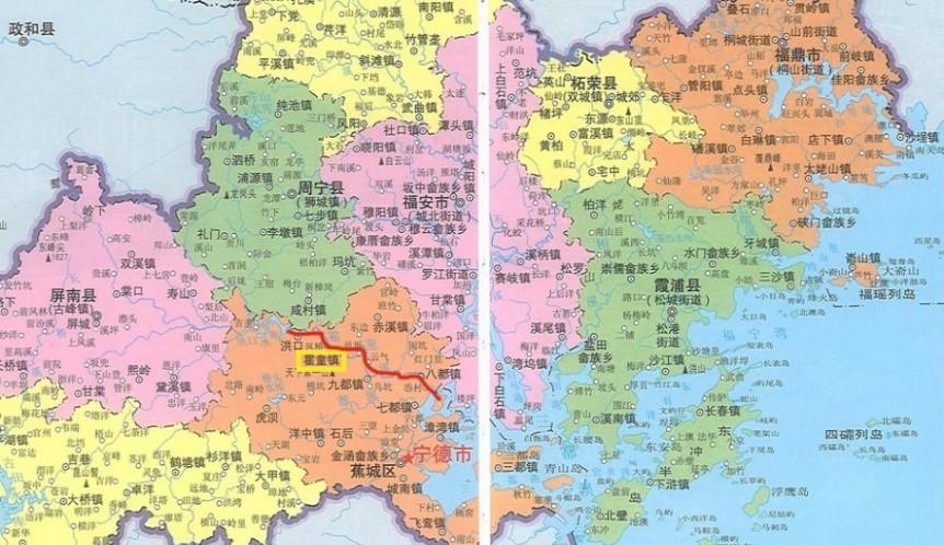
Figure 1 Location map of Huotong Creek (excerpt from the Atlas of Ningde City)
Huotong Creek originates in the southeastern foothills of the Vulture Peak Mountains and flows southeast through Jiaocheng District to the sea at Sanduao. The "Chronicle of Ningde County" says: "Its source is from the political and county boundaries, descending from the Yuchuan River, and the Xiancun River and the water from the Xiangshan Rock will flow in the Waixiao Creek." Through the villages of Jiahou, Dutou, Qingyan, Shiqiao, Bantou and other villages, we reach Huotong. [1] The Zhiti Temple Tuzhi also records about the source of Huotong Creek: "There are three sources of Huotong Creek: one from Xian Village, one from Yingzhou, and the second from One Hundred Steps. From Xiaoshiling to Phoenix Bridge and Erxi convergence into one. [2] To put it simply, the upper reaches of Huotong Creek come from two directions: Xiancun in the north and Juzhou and Hongkou in the west. It merges into Baibu Village, enters the Huotong Valley, flows through Shiqiao, Huotong, Yisaka, Guicun, Fuyu, Xichi, enters the sea in Badu, and finally flows into Sanduao.
"Ningde County Chronicle , Volume I : Mountains and Rivers" " The largest person in Ningshan is like Huo Tong, so the largest person in Ningchuan is also like Huo Tong." [3] For a long time, Huotong Creek has provided abundant hydraulic resources for farmland water conservancy, freshwater fishing, production and transportation in the basin through which it passes. Through the survey, it was found that there are at least four types of people in the Huotong Creek basin, namely: farmers living by the mountains, river people transporting inland water, offshore fishermen who make a living from fishing, and dock people in maritime ports. In the following, this article will take today's Shiqiao Village, Huoxi Village, Starfish Village and Ju'an Village as examples to illustrate the way of life of these four people who are separated from each other and "drink one stream together".
Farmers nourished by the tributaries of Huotong Creek: Take Shiqiao Village in Huotong Town as an example
In the 126-kilometer basin of Huotong Creek, the largest number of people and the main position are the shore dwellers living on both sides of the river. However, unlike the general experience of "relying on mountains to eat mountains and relying on water to draft water", farmers living on both sides of Huotong Creek do not directly use the nearest Huotong Creek, but open canals from the mountains to divert water and use mountain springs. Judging from our research, the villages on both sides of Huotong Creek have very complete and exquisite water conservancy systems to solve the problem of water for production and domestic use in the village, and what is more interesting is that most of these water conservancy systems will not be directly linked to Huotong Creek. The mountain spring water is self-contained and recycled, and is not directly discharged into huotong Creek, so the water conservancy system in the village is relatively independent.
There are two main reasons for the above phenomenon: First, Huotong Creek is in a river valley, the terrain on both sides is high, and it is inconvenient to divert water from the stream. Correspondingly, the hydraulic power formed by the drop can drive the operation of production tools such as water pillars; second, there are many floods in the Huotong Creek Basin, and in order to prevent flooding, all villages along the coast have a long tradition of planting banyan trees to prevent flood control, and rows of ancient banyan trees are the natural and effective embankments of the villages (Figure 3). Each village genealogy has strict rules for the protection of banyan trees, and the protection of river embankments is the top priority for the survival of the village, let alone the opening of the embankment to divert water. Stonebridge Village is typical.

Figure 2 Map of the Huotong Creek Basin (excerpted from the 13th series of Ningde Wenshi Materials)
Figure 3 Ancient banyan tree by the river (Photo by Ye Weiqi in 2020)
Shiqiao Village is a single surname village, and the whole village is surnamed Huang. The village is located a few hundred meters upstream of Huotong Village, on the south bank of Huotong Creek (as shown in Figure 4), and is also the site of the Huangju Water Conservancy Project, a world heritage of irrigation engineering. The villagers believe that the Sui Dynasty counselor Huang Ju resigned from the world and came to the stone bridge to build the Huangju Water Conservancy Project, which has blessed future generations.
Figure 4 Location relationship between Shiqiao Village and Huotong Town (from Gaode Map)
The article "The Founding of the Stone Bridge" in the Huang family tree describes the water conservancy system in the village in detail and clearly: "The stone bridge leans on the north and faces the south, the room and family are connected to The Yu, and its Yang is flat and the domain is fertile and fertile. The middle of the ring village is the street, and the road side is dissolved into a ditch, that is, it is the cause of the waterway, and the water out of the ditch, the source of which is due to the large stone pit, over the dragon waist, the field is strange, and enters the village. The ditch went from the street to the ancestral hall a little, and then returned to the field to moisturize the ze. The ditch is nine folds, so it is called nine curves of water, and there are three stones of toads in the nine curves to calm the flow. Twenty-five floors of stone are built on the street, and the rest of the ping is built, that is, the place where the god of racing sleigh is in February of the year, and there are three large and small lakes outside the ping, named the sun, the moon, and the three lakes of the stars, which are chiseled by the ancestors to suppress Mars also. It is also said that the three lakes are connected, and the shape is like a flying crane. In the middle of the village, there are three stone toads in the middle of the nine folds, so as to calm the turbulence, so it is called 'three toads and nine curved water'". [4]
Figure 5 Schematic map of Huangju World Irrigation Engineering Heritage (quoted from Shiqiao Village brochure)
As shown in the figure above, the Huangju Water Conservancy Project diverts water from Dashikeng Creek, a tributary of Huotong Creek, because the opening canal is located in the middle of the local feng shui dragon vein, which is called the dragon waist, so it is called the dragon waist canal. Flowing through the Longwaist Canal to Shiqiao Village, the stream is divided into two branches, east and west, irrigating farmland in the west, and flowing all the way down to longwaist water. The Dragon Waist Water Pillar was built with a drop of about 15 meters and is divided into five levels (5 seats) for grain processing. (As shown in Figures 6 and 7) consists of a gate, a water wheel, a mill rock, a mill rock, a hammer, and a sieve box, and a water wheel drives a water wheel, and the water wheel drives a mill rock, a mill rock, a hammer, and a sieve box, and after crushing the grain, it enters the sieve box, and separates the grain bark and grain center through the sieve pendulum to form grain such as rice and flour. Once the floodgates are opened, it is equivalent to five small workshops starting at the same time, which has effectively solved the production and processing problems of the villagers for a long time in the past, and is highly efficient and energy-saving. After the water flows through the water pillar, it is divided into two branches, one for irrigation of good land, and the other for directly introduced into the village as the villagers' living water, sometimes to the right, sometimes to the left, in order to fairly take into account the families in the village, so the formation of the Jiuqu. The three lakes of the sun, moon and star flowing through the stream at the head of the village, the "Yan Pond" and "Goldfish Pond" in front of the Huang Clan Hall in the village, and the "Xingluo Lake" at the end of the village have formed a complete water conservancy system that takes into account production and life, irrigation and fire protection.
Figure 6 Grade 5 Water Pillar in Shiqiao Village (Photographed by Ye Weiqi in 2020)
Figure 7 Grade 5 Water Pillar in Shiqiao Village (Photographed by Ye Weiqi in 2020)
The above-mentioned water conservancy facilities for opening mountains and diverting canals have been recorded as early as the Song Dynasty's "Chunxi Three Mountains Chronicle": "Xian Lake, Tuoping Lake, Tangbei Lake: Hui Xiao Xi Water, Sui Zhi Huang Gongchuang, Irrigation Field More than a thousand acres." [5] The Xian Lake, Duping Lake, and Tangbei Lake mentioned in the book are all formed by bringing together many small streams, which is similar to the Xingluo Lake and Goldfish Pond in the present-day Shiqiao Village. More importantly, this kind of water conservancy project that does not divert water from Huotong Creek is not unique in the Huotong River Basin, and many villages along the creek have built water channels similar to Huangju Water Conservancy. For these farmers, who had traditionally not relied on Khotong Creek for water or irrigation (of course today is very different), Khötton Creek existed for them first and foremost only as a "waterway" of transport arteries. This is fundamentally different from the way jiangers who live in the creek and call their boats their homes in their livelihoods and water use.
Second, generations of inland river people who have taken boats as their home: Huoxi Village, Huotong Town
Figure 8 Location map of Huoxi Village (from Gaode map)
Huoxi Village, Huotong Town, is located in the northwest area of Huotong Town, adjacent to Huotong Creek, which is a village formed after the Jiangmin who originally lived in Huotong Creek came ashore, and is administratively parallel to the local Huotong Village and Dongtian Community, but does not mix with the villagers of the other two villages, and presents a relatively independent state. For generations, they have been mainly engaged in transportation on Huotong Creek, supplemented by fishing, which is the basis for the existence of the Huotong Creek waterway. Although these jiangmin people have all come ashore, they still do not farm and are not accustomed to land, and their main source of livelihood still revolves around Huotong Creek. But now the dams on the creek are cut off, the waterways are cut off, and the boats that shuttle between the valleys are no longer useful, and in addition to going away, these water river people can only fish for aquatic products in the stream for a living. But in any case, before going ashore, Huoxi villagers rarely fished, which is the most important reason why this article calls them "Jiangmin" rather than "fishermen". If the peasants are the masters of the land, then the Jiangmin are the masters of Huotong Creek, as they say: "The river of Huotong Creek from Hongkou to Badu is our field, it belongs to our watershed, and only our village is eligible to fish." ”
Figure 9 Huo Tong Xi (Photo by Ye Weiqi in 2021)
Figure 10 Huo Tong Xi (Photo by Ye Weiqi in 2021)
Huoxi Village is a single surname village, Jiangmin surnamed Zheng, according to the villagers themselves they have been a family since ancient times. However, due to the lack of genealogy and written records, they have different opinions about the origin of their ancestors: some believe that Zheng's ancestors moved here from Fu'an during the Jiaqing period, but others believe that their earliest ancestors can be traced back to Xingyang, Henan, the birthplace of the Zheng surname.
Since the development of the commodity economy in northern Fujian in the Song Dynasty, the transportation of the entire mountainous area of the river basin has completely relied on Huotong Creek. The main activities of the Jiangmin people, who make a living from water transport, are concentrated in the Hongkou-Huotong-Badu line. The water flow in the basin from Hongkou to Huotong is relatively turbulent, and the transportation is mainly based on discharge. From Huotong to Badu, it is the world of lianjia ships.
Figure 11 Map of the Huotong Creek Basin (excerpted from the 13th series of Ningde Wenshi Materials)
As the name suggests, the wood or bamboo is tied into rafts down the river, mainly used to transport wood and bamboo produced in Hongkou, Juzhou and other places, but also to carry some relatively light goods such as tea. In addition to the Jiangmin on Huotong Creek, some villagers in Hongkou also master this technology. However, whether it is the villagers of Hongkou or the platoon released by huoxi jiangmin, after arriving at the port of Huotong Town, it must be collected by the jiangmin and then carried to Badu. The Hongkou-Huotong line is steep and the water flow is the most cost-effective mode of transportation, and this livelihood continued until the 1980s and 1990s, and it is still a intangible cultural heritage and tourism preservation project in Hongkou Township.
Huotong and Badu are the two terminals that connect the mountains and the sea. Most of the goods transported back to Huotong by Badu are salt, shell ash, salted fish goods, daily necessities, etc., while the goods from Huotong to the sea are mostly firewood, wood, native products and grain. Between these two ends, the Huoxi River weaves a fine route with their lianjia boats. In fact, even family boats can go to sea, and the old people recall that they could go down to Sanduo, Saiqi Wharf and Fu'an, and upwards to Pingnan and Xiancun, but very few of them went. Going upstream is high and the water is urgent, and even the family boat is not as efficient as the discharge. Going out of Haikou is also more than worth the loss, the return trip is mostly counter-current, most of them need to pull a boat to go up, so unless there is a designated order, Jiangmin will not go to a place outside the Bayu Sea.
In the 1950s and 1960s, there were about 200 Zheng jiangmin on Huotong Creek, and more than 30 family boats, which were the main force in the transportation of bulk goods in the basin. In recent years, there has been a lot of research on the history of "people on the water", but what the research group wants to point out is that there are strong technical barriers to water transportation, which on the one hand makes the income of Jiangmin not low, but on the other hand, it is also an important reason why they have an invisible boundary between them and "people on the shore". In 1958, the Ningde Municipal People's Government organized the establishment of a collective-owned transportation society, and all Jiangmin joined the society, but still lived on the water. The old people recalled that the Jiangmin people thought that they were of low status and had difficulty in marrying wives, and they could not even wear shoes when they went ashore, because "bent hooves and feet" were the direct signs that distinguished them from "people on the shore". Jiangmin often rescued people who had lost their feet and fell into the water, but never accepted remuneration, on the grounds that they did not dare (or did not want to) participate in the personal exchanges of "people on the shore", preferring to become their own and take the boat as their home. There is an "invisible boundary" between Jiangmin and peasants, which is embodied in all aspects, which is an important problem discovered by a large number of anthropologists and historians in the study of the people and the "people on the water".
In April 1966, the government set aside land at Dashi Farm to allow the Jiang people to live ashore, but because they could not farm, they soon returned to Huotong Creek. It was not until the road was gradually completed and opened to traffic in 1975 that the water transport of Huotong Creek declined, and the Jiangmin who had lost their source of livelihood had to start leaving the Lianjia boat one after another. In 1998, when Comrade Xi Jinping was in office, he promoted the "Lianjia Boat Shore Benefit Project", until 2004, when more than 300 people from Jiangmin finally landed. In 2013, Huoxi Village was officially established, but the "water people" have since changed their identity as "Jiangmin" and have been certified as "fishermen" for their current production activities.
Historically, however, the Huoxi river people focused on releasing row boats, rarely fishing for aquatic products, and forbidding other groups to go down the river to fish. As the "owners of Huotong Creek", they cherish this water home incomparably. Under their protection, the creek was once drought and flooded, the stream was clear, there were many fish, and the ecology was excellent. However, with the transformation of economic mode, especially the completion of badu Reservoir and Hongkou Reservoir, the ecological environment of Huotong creek has been greatly affected. In order to store water for power generation, the reservoir has caused Huotong Creek to operate at a low water level all year round, and the fish cannot survive. At the same time, the reservoir with high water level power generation all year round can not play a role in flood storage, but increases the flood hazard, and the knowledge of flood control passed down from generation to generation by huoxi jiangmin has become helpless under the intervention of the reservoir. However, despite the deterioration of the environment, the villagers of Huoxi Village still have a high emotional attachment and identification with Huotong Creek: "The water of our Huotong Creek is clean, the fish are clean", "This is our home, our field".
3. Offshore fishermen engaged in fishing full-time: Take Starfish Village in Badu Town as an example
Follow huotong creek all the way down to Badu Town, which is the outlet of Huotong creek. Brackish water and fresh water are demarcated here, narrow inland waterways are widened from here, and the Zheng surnamed Jiangmin on Huotong Creek rarely sets foot in the waters outside Badu, while the offshore fishermen represented by Starfish Village fish at the mouth of the sea to make a living.
Figure 12 Location map of Starfish Village (from AutoNavi map)
Located a few hundred meters downstream of Badu Town (Figure 12), Starfish Village has been established since the 1950s and is home to fishermen from the coastal area. At the beginning of the establishment of the village, there were about 500 fishermen and nearly 100 fishing boats. In 1998, Starfish Village was the direct beneficiary of the benefit project of lianjia ship ashore. By 2010, more than 200 families of fishermen had all disembarked. So far, there are still more than 50 people in the village who make a living from fishing, and there are more than 180 fishing boats of various types, with costs ranging from 10,000 to 30,000.
Figure 13 Fishing boats and fishermen in Starfish Village (Photo by Ye Weiqi in 2021)
Figure 14 Fishing boats and fishermen in Starfish Village (Photo by Ye Weiqi in 2021)
Unlike Huoxi Jiangmin, who belong to the same Zheng family, the fishermen of Starfish Village mainly have four surnames: Lin, Bian, Tang and Weng, which come from different ancestral places. Taking the Surname of Lin as an example, they are mainly from Qidu, Fu'an and other places, and after landing on the shore, they merged with the Badu Lin clan to have a family tree, and since then they have been traced back to Lin Cong of The Eight Capitals Xiasaka Village as the ancestor. The main area of activity of these offshore fishermen is concentrated in the area from Badu to Doumu (Figure 15), that is, the offshore area. Old people recall that their furthest fishing range can reach Zhoushan, Zhejiang Province, specializing in catching wild yellow croaker. But no matter where you go, you will definitely return to the vicinity of Starfish Village at night, and you can't return on the same day, nor will you leave the village for more than a week. This offshore area, not the entire fishing range, is their "home".
Figure 15 Map of the location of Starfish Village and Doumu (from Gaode map)
The location of Starfish Village is considered home, first of all because it is a natural haven. Fishermen must return regularly to repair their boats and trade supplies, and this port is a relatively stable anchor in a moving ocean. In the "homeland", the docking position of the fishing boat in Starfish Village is also extremely exquisite, each vessel has a fixed parking position, such as the beach and other good stops are mostly inherited from the ancestors, the sea has a boundary, just like the soil has a boundary, and the beach and sea boundary are actually "ancestral relics".
Unfortunately, this "relic of the ancestors" is also greatly challenged today. In addition to the deterioration of waterways caused by flood estuarine reservoirs and the occurrence of floods, the reclamation of the sea at the mouth of the sea has a greater impact on them. Yuntan Island, outside the mouth of the Badu Sea, was once an important place for Qi Jiguang to fight and an important island outside Haikou. After the water of Huotong Creek entered the sea, it originally flowed into the ocean from the east and west sides of Yuntan Island (Figure 16). Especially in the west, the open ocean, gentle water flow and abundant products are the coastal fishing grounds on which the fishermen of Starfish Village have relied for generations. However, in order to build a factory a few years ago, the entire tributary was directly filled in, and the fishermen could only turn to the small branch in the east, which was the main reason why local aquaculture and fishing were difficult to sustain in recent years. (Figure 17)
Figure 16 Map of the estuary of Huotong Creek before reclamation (from the Atlas of Ningde City)
Figure 17 Map of the estuary of Huotong Creek after reclamation (from Gaode Map)
Fourth, dock people: Take The Case of Ju'an Village in Badu Town
In addition to farmers who rely on the stream to nourish the land, and river people and fishermen who call water as their home, Huotong Creek also raises a fourth group of livelihoods: dock people, especially the Badu pier is the largest and most organized.
Dockers in Badu have two main ways of subsistence: dock handling and offshore shipping. The latter category of "sea sailors" was small in Badu and had only over 80 in the 1950s. They are rooted in the docks, and in addition to the young and middle-aged men, women, children, and children, all live on the docks for their livelihoods, and in their own words, "we have always been on the shore", which is the main reason why these sailors are also regarded as dockers in this article.
Figure 18 Location map of Ju'an community (from AutoNavi map)
Like the outer seafarers, the number of dock workers directly engaged in cargo handling is also small, about 60 in the 1950s, but this number is also only the young and middle-aged labor force in this group. According to the old people's recollection, the dock workers had their own guild, which was always divided into four groups, one group on duty, one group reserve, and the order was orderly. Their range of activities has three main distribution points: Badu Wharf, Starfish Village in Badu Town, and Sanyu Village in Qidu Town. Specifically, because Sanyu islands were near the sea in the past, they mainly docked large tonnage ships; medium-sized ships docked starfish; and smaller ships entered Badu Wharf. Therefore, the goods handled at the three terminals are not exactly the same, and the porters also need a more detailed internal division of labor and cooperation. For example, the timber from Hongkou Juzhou came ashore from Badu and then transferred to the Sanyu Timber Factory for unified processing before it could be put on a ship and went to sea. All dock workers must be uniformly deployed and shifted to ensure the effective flow of goods.
Figure 19 The original Badu Pier site has now built a sinking trail along the river (Photo by Ye Weiqi in 2021)
At the end of the article, we can see that even people living next to each other in the same river basin will form a group with boundaries because of their different relationships with "mountains and rivers" and different ways of livelihood, and infiltrated into different "sense of place". In the Huotong Creek basin, water connects mountains and connects to the endless ocean. Whether it is farmers who are highly vigilant about limited land resources, jiangmin who are active in fixed river basins, or offshore fishermen who rely on marine resources and groups that live on docks and ports, they all coexist with heaven and earth within the boundaries of "our group", enjoying the gifts of water and soil on this side, and achieving subtle balance and symbiosis in the division of labor and cooperation.
bibliography:
[1] [Qing] Lu Jianqixiu, Edited by Zhang Junbin, Chronicle of Ningde County, Xiamen: Xiamen University Press, 2012, p. 41.
[2] [Qing] Cui Ling, "Ningde Zhiti Temple Atlas", Fuzhou: Fujian Provincial Map Publishing House, p. 13.
[3] [Qing] Lu Jianqixiu, edited by Zhang Junbin, Chronicle of Ningde County, Xiamen: Xiamen University Press, 2012, p. 41.
[4] Excerpt from the Huang clan genealogy of Shiqiao Village.
[5] [Song] Edited by Liang Kejia, compiled by fuzhou local history compilation committee, Chunxi Sanshan Zhi, Fuzhou: Haifeng Publishing House, 2000 edition, p. 187.
Editor-in-Charge: Huang Xiaofeng
Proofreader: Luan Meng