1. Administrative division of Chuanhui District, Zhoukou City
In February 1948, Zhoukou City set up Nanzhai District and Beizhai District. Later, 12 town offices were set up, nanzhai district jurisdiction yuelai, Pifang, Phoenix, Xida, Xinjie, Shanwu, Yongxing 7 towns, Beizhai district jurisdiction Taiping, Sanyi, Xizhai, workshop, Mopan 5 towns. In May, 12 town offices were merged into 10: Sanyi, Xizhai, Yongxing, Xida, Fenghuang, Dehua, Taiping, Workshop, Yuelai, and Shanwu. The countryside near the towns are also under the jurisdiction of the towns. In August, the 10 town offices were further reduced to 6: Taiping, Dehua, Yuelai, Xida, Fenghuang, and Xizhai. In December, the Nanzhai District and the Beizhai District were abolished.
In May 1950, Xihua, Huaiyang and Shangshui counties were assigned to 85 villages in Zhoukou City, and the suburbs of Zhoukou City were established, with the following jurisdiction: Sunzui, Wangying, Wuli, Shuiguantai, Wangzhuang, Caozhai, Shibei and Shinan 8 townships.
On June 10, 1952, Zhoukou City was changed to Zhoukou Town, which came under the jurisdiction of Shangshui County. On November 10, 1953, Zhoukou Town was changed to Zhoukou City and became independent from Shangshui County.
In 1955, Zhoukou City abolished 6 towns and replaced them with 4 subdistrict offices: Renhe, Xiaoqiao, Yongxing, and Pangong; by October 1956, the Chenzhou (Hui) Subdistrict Office had been newly established. In March 1956, the 8 townships in the suburbs of Zhoukou were reduced to 4 townships: Li Duolou, Peng Xinzhuang, Yanzhuang, Liu Fangping (or Niuying); by October, they were further reduced to 2 townships: Shinan and Shibei; by April 1958, the 2 townships of Shinan and Shibei were downsized and merged into suburban townships.
On April 7, 1958, Zhoukou City was changed to Zhoukou Town (renamed Zhoukou Commune in April 1959), and was merged into Shangshui for the second time. In March 1960, Zhoukou Commune set up The Sha'nan and Shabei Branches, under the jurisdiction of the Shabei Branch, there were two subdistrict offices of Renhe and Xiaoqiao, and then the subdistrict office was abolished and the three management areas of Hongqi, Mill and Workshop were set up; the Shanan Branch had three subdistrict offices of Pangong, Yongxing and Chenzhou, and then abolished the subdistrict office and changed to four management districts of Chenzhou, Xinhua, Yongxing and Xinjie. In September, Zhoukou Commune abolished its branches and reduced the number of 7 administrative districts to 5: Mopan, Hongqi, Xinjie, Yongxing, and Chenzhou.
In February 1961, Zhoukou Commune was renamed Zhoukou Town, and the five administrative districts of Zhoukou Commune were renamed 5 subdistrict offices. In August, the suburban townships of Zhoukou Town established four township communes: Pengxinzhuang, Liduolou, Xiyangzhuang and Shuiguantai. In August 1962, the four township communes on the outskirts of Zhoukou Town were merged into the suburban communes of Zhoukou Town.
On November 25, 1965, Zhoukou Town was changed to a special town, and for the second time it became independent from Shangshui County. The original 3 subdistrict offices (Mopan, Hongqi, Xinjie) of Zhoukou Town were changed to: Renhe, Xiaoqiao, Pangong, Yongxing, Chenzhou 2 subdistrict offices remain unchanged. In January 1966, a new vegetable street office was established in Zhoukou Town, and a total of 6 street offices have been established.
Later, the 6 subdistrict offices of Zhoukou Town were downsized to 2 subdistrict offices in Shanan and Shabei.
In March 1972, the suburban communes of Zhoukou Town were divided into two communes: the southern suburbs and the northern suburbs.
On March 19, 1972, there were 5 brigades in Xizhanglou, Mazhuang, Zhaozhai, Guobukou and Chentan of Qiankou Commune in Huaiyang County; Xiaowangying and Zhongcun of Tangzhuang Commune in Shangshui County, Xuzhai, Chaitang and Aiying in Chengguan Commune of Shangshui County, Yangjingyan (Ya) of Lianji Commune in Shangshui County, Zhao Zhai, Dongdanzhuang, Mengying and Zhengwa of Libukou Commune in Shangshui County, a total of 10 brigades; Youzhuang, Xiakou and Dangzhuang of Dawangzhuang Commune in Xihua County, Xialuo, Liying and Xuying of Piying Commune in Xihua County, a total of 6 brigades. It was placed under the jurisdiction of Zhoukou Town.
In 1975, Zhoukou had a new Yinghe Commune under the jurisdiction of The town, which had 8 brigades under its jurisdiction: Qianjin, Zhangbukou, Sunzui, Pengxinzhuang, Dongfeng, Guozhuang, Dangzhuang and Xiakou. In 1979, a new vegetable commune was built in Zhoukou Town. In 1981, Yinghe Commune was abolished and merged into the Northern Suburbs Commune.
In October 1980, the town under the jurisdiction of Zhoukou was renamed Zhoukou City.
In April 1983, Zhoukou City abolished the two subdistrict offices of Shanan and Shabei and replaced (expanded) 11 subdistrict offices: Renhe Street, Xiaoqiao Street, Workers' Road, Jianshe Road, Xinjie Street, Chenzhou Street (Hui), Bayi Road, Qiyi Road, Hehua Road, Railway Station, and Textile Road (now the western section of Qiyi Road).
On December 30, 1984, the northern suburbs, southern suburbs and vegetable communes of Zhoukou City were renamed as northern suburbs, southern suburbs and vegetable townships.
In October 1984, the 11 subdistrict offices in Zhoukou City were downsized to 5: Renhe Street, Xiaoqiao Street, Chenzhou Street (Hui), Qiyi Road, and Textile Road (now the western section of Qiyi Road). The old street under the jurisdiction of the Hui Street Office of the Municipal Government in Chenzhou Street.
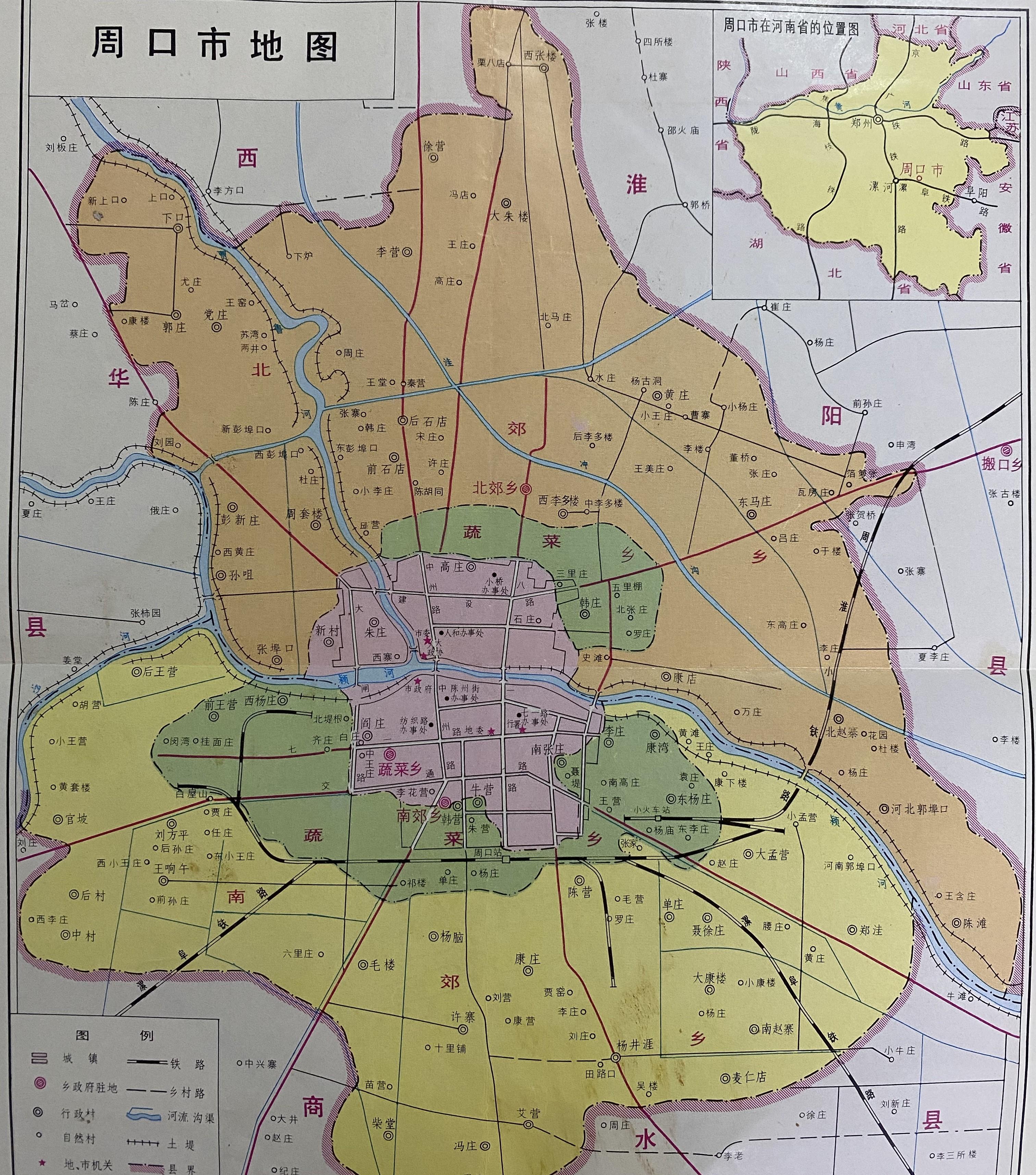
On June 8, 2000, Zhoukou District was renamed Prefecture-level Zhoukou City, and county-level Zhoukou City was renamed Chuanhui District. In 2000, the total population of Chuanhui District was 323,738, including: 18,720 in Chenzhou, 72,373 on Qiyi Road, 19,332 on Textile Road, 27,409 in Renhe, 23,189 in Xiaoqiao, 51,894 in Nanjiao Township, 46,043 in Beijiao Township, 41,075 in Vegetable Township, 8,491 in Shachang Virtual Street, and 15,212 in Economic and Technological Development Zone.
In 2004, huaiyang county's moving mouth township was transferred to the jurisdiction of Chuanhui District. The total area of Tuokou Township is 66 square kilometers, with a total population of 47,000. After this administrative adjustment, the population of Chuanhui District increased from 376,000 before the adjustment to 422,000.
In 2005, Vegetable Township, Nanjiao Township, Beijiao Township and Qiankou Township were abolished, and corresponding subdistrict offices were set up (Chengdong, Chengnan Subdistrict, Chengbei Subdistrict, and Moving Mouth Subdistrict). Later, Chengdong Subdistrict was abolished, and its jurisdiction was merged into Chenzhou, Textile Road (later renamed Lotus Street), Qiyi Road, Renhe, Xiaoqiao and other streets.
In 2006, Libukou Township in Shangshui County was transferred to the jurisdiction of Chuanhui District of Zhoukou City.
Lizhuang, Zhaozhai, Kangdian, Wanzhuang, Chentan and Guobukou in Chengbei Subdistrict were demarcated and separately established as Wenchang Subdistrict Office.
On February 28, 2011, the two subdistrict offices of Wenchang and Qiankou in Chuanhui District and Xuwan Township in Huaiyang County were transferred to the management committee of Dongxin District of Zhoukou City.
On August 17, 2012, Fengzhuang and Chaitang 2 organized villages of Taihao Road Subdistrict Office in Chuanhui District were transferred to the jurisdiction of Chengguan Township, Shangshui County.
2. Chenzhou Street Hui Street Office
It is bounded by Dazha Road in the west, Bayi Road in the east, Bank Hutong (on the south side of Pifang Street) in the south, and Yinghe in the north. The Subdistrict Office took over the north side of Houzhangying and had jurisdiction over 13 neighborhood committees of Ningzhuang Street, Yuelai Street, Chenzhou Street, Qianzhangying Street, Pifang Street, Beiyongguang Street, Nanshan Freight Street, Xinjie, Wenhua Street, Heping Street, West Street, and Huajingtai Street. Because the main street in the jurisdiction, Chenzhou Street, was originally a Hui residential area, it was named.
In 1948, it was named Yuelai Town, in 1952 it was renamed Yuelai Administrative Street, in 1953 it was established as the Chenzhou Hui Autonomous Region Government, and in 1956 it was renamed Chenzhou Subdistrict Office. In March 1960, it was merged into the Shanan Branch, and in September, the Chenzhou Management District of the Shanan Branch was established. In 1962, the Chenzhou Administrative District was renamed the Chenzhou Subdistrict Office. In 1967, it was named the Anti-Repair Street Office. In 1973, it was merged into the Shanan Subdistrict Office. In 1983, the Shanan Subdistrict Office dissolved the Chenzhou Street Hui Street Office.
The jurisdiction is adjacent to the confluence of shaying river and Jialu river and Zhongzhou Road Bridge (Laoyang Bridge), which is the earliest development area on the south bank of the Shaying River in Zhoukou. A street in Zhoukou --- Meridian Street (now Laojie), the earliest ferry port ---- Zhoujiabukou, the earliest street named after the industry---- Shan cargo street, Oil Fang Street, Pifang Street, Xifangzi Street are distributed here. At the peak of the late Ming and early Qing dynasties, there were 7 ferries and 12 gates. Zhoukou used to be "Eight Views of Yingchuan" downtown wheel hoof, riverside fishing singing, port crossing, Tai'an Jixue, Puji bells, Liuxiang Sheng song and other landscapes here.
There are Yinghe Shopping Mall (north of the middle section of Jianxin Road, selling electricity), Zhoukou Department Store and other commercial vendors, Dashi street and Dajing along the 2 cooked food trading markets that are more than 100 years old, cooked food trade and night market stalls until midnight. There are cultural primary schools, Zhoukou No. 3 Middle School (formerly Zhoukou No. 8 Middle School), vocational secondary school, maternal and child health hospital, the Third People's Hospital, Jutong Cable Group (formerly Zhoukou Cable Factory) and other units.
1. Ningzhuang Street Neighborhood Committee
It has jurisdiction over No. 48-338 Renmin West Road, with 685 households and 1782 people in 2002, including 1054 Hui people, which is one of the Hui settlements in Zhoukou City. The neighborhood committee was established in December 1983, and the jurisdiction area was Ningzhuang Street at that time, hence the name. Huaiqing Mosque and Zhoukou Municipal Bureau of Quality and Technical Supervision are stationed here.
2. Yuelai Street Neighborhood Committee
It has jurisdiction over Zhoubin Middle Road (Shayinghe South Road) between Yuelai Street and Xindukou Street North Exit to Bayi Road Shayinghe Bridge (Shengli Bridge), with 293 households and 1128 people in 2002. Originally belonged to the Chenzhou Street Neighborhood Committee, it was established in 1966 and named Yuejin Road Neighborhood Committee. Because the main street under its jurisdiction is Yue Lai Street, it was renamed to its current name in 1982.
Yuelai Street, from Chenzhou Street in the west to the northern end of Ningzhuangkeng in the east, is 350 meters long and has a triangular distribution. It is a Hui settlement. It belongs to the Chenzhou Street Neighborhood Committee and the Yuelai Street Neighborhood Committee. In 1918, the "Chronicle of Continuing to Repair Shangshui County" recorded that in the middle of the Qing Dynasty, Zhoukou commerce was prosperous, thousands of merchants gathered, and inns were lined up, taking the meaning of "near yue, far away coming", taking the name Yuelai Street. It was renamed Anti-Repair Street in 1967 and restored to its original name in 1982.
3. Former Zhangying Neighborhood Committee
It has jurisdiction over Renmin Road between Jiepai Street, Stadium Hutong, Sanlian Kengkou and Zhongzhou Road. In 2002, there were 453 households and 1672 people, including 756 Hui, which was one of the Hui gathering areas. Because the neighborhood committee is stationed in qianzhangying Street, it is named. In 1966, it was renamed Renmin Road Neighborhood Committee, and in 1983 it was renamed to its current name. Fur factory, municipal engineering department, municipal management office, film company, the Third People's Hospital, Jutong Cable Group (formerly Zhoukou Cable Factory) are stationed here.
Jiepai Street, from Qinghe Street in the north to Qiyi Road in the south, is 250 meters long. When this street was first built, there was a boundary plate, which belonged to Shangshui County in the west and Huaiyang County in the east, so it was named Jiepai Street. It is also divided into South Boundary Pai Street and North Boundary Pai Street. In 1967, the south and north boundary Pai Street merged and renamed Yuejin Road (south section), and in 1982 it was restored to its original name (Jie Pai Street).
Stadium Hutong, from Jiepai Street in the west to the north of the Family Hospital of the Post and Telecommunications Bureau in the east, is 200 meters long and has a rectangular distribution. On the north side of the hutong are row houses for residents, and on the south side are the Zhoukou City Stadium and the Zhoukou City Trade Union Office. In the western part of the hutong, there is the Zhoukou Film Company. The hutong was originally jiepai street, because it was located after the Zhoukou City Stadium, and was named separately in 1987.
4. Pifang Street Neighborhood Committee
It has jurisdiction over Pifang Street, Bank Hutong, the east side of Zhongzhou South Road (south of the west entrance of Renmin Road to the north of the Post and Telecommunications Building), with 344 households and 1350 people in 2002. The neighborhood committee was newly built in 1983 and named after the main street under its jurisdiction--- Pifang Street. Originally under the jurisdiction of the Qiyi Road Street Office, it was transferred to the jurisdiction of the Chenzhou Hui Street Office in 1987. Chuanhui District Cultural Center, The State Taxation Bureau, and the Second Tannery are located here.
Pifang Street, from Renmin Road in the north, to Bank Hutong in the south, to Jiepai Street in the east, is 323 meters long. At the end of the Ming Dynasty and the beginning of the Qing Dynasty, from Beijing, Tianjin, Nanjing, Jining City, Shandong Province, Sangpo Village, Xingyang, Yu County and other places in Mengxian County, Henan Province, some cobblers came to settle here and produce leather goods, so the street was named after the fang. It was renamed Red Star Street in 1967 and restored to its original name in 1982. The second tannery is located here.
Bank Hutong, from Jiepai Street in the east to Pifang Street in the west, is 100 meters long. Because it is located on the south side of Pifang Street, it was formerly known as Pifang South Street. In 1967, it was renamed Red Star Street. Later, because it was located behind the People's Bank of Zhoukou City (now moved to the intersection of Zhongzhou Road and Qiyi Road) and was the address of some employees of the bank, it was renamed Bank Hutong in 1982.
5. Chenzhou Street Neighborhood Committee
It has jurisdiction over Chenzhou Street, Xindukou Street, Qinghe Street and Yuelai Street, with 665 households and 1820 people (including 1429 Hui people) in 2002, which is a concentrated residential area for Hui nationality. In 1966, it was renamed the Anti-Repair Neighborhood Committee, and in 1982 it was renamed to its original name.
Chenzhou Street. In 1918, the "Chronicle of Shangshui County" recorded that this street was first built during the Qing Xianfeng period and came under the jurisdiction of Chen Prefecture (present-day Huaiyang County), hence the name. In 1967, it merged with Yuelai Street to form anti-repair street, and in 1982 it was restored to its original name. In 1985, when Dongfanghong Avenue (now Zhongzhou Road) was expanded, it occupied the western part of Dongpan Gong Street; in 1987, the remaining East Pan Gong Street was assigned to Chen Zhou Street, so the street extended westward, from Yuelai Street in the east to Zhongzhou South Road in the west, with a length of 250 meters. The Huimin Primary School and Chenzhou Mosque are stationed here, which is a Hui settlement.
Xindukou Street, from Qinghe Street (now merged into Jiepai Street) in the south and Zhoubin Middle Road (now Binhe Road or Shayinghe South Road) in the north, is 80 meters long. Because the new ferry port, one of the main ferries in the original Zhoujiakou, is located at the northern end of this street, it is named. In 1967, it was renamed Yuejin Road (North Section) and restored to its original name in 1982.
Qinghe Street, from Xindukou Street in the north to Jiepai Street in the south, is 20 meters long. Although the street is adjacent to the downtown, the street is secluded, the environment is quiet, and the Hui and Han people live in harmony, so the street is named after "quiet and harmonious". In 1967, it was renamed Yuejin Road (North Section), and in 1982 it was renamed Qinghe Street, which has now been merged into Jiepai Street.
6. Mass Street Neighborhood Committee
It has jurisdiction over a section of Dazhong Street, Xinsheng Street and Zhoubin Middle Road, with 182 households and 650 people in 2002.
Volkswagen Street, alias Pastoral, Oil Mill Street. It runs from Zhoubin Middle Road in the north to Chenzhou Street in the south, with a length of 160 meters. In 1918, the "Chronicle of Continuing to Repair Shangshui County" said that during the Qing Dynasty, this street was full of oil mills, and was formerly known as Oil Mill Street. In the early days of the founding of the People's Republic of China, the Shangshui County Popular Theater Troupe was stationed in this street, and performed in this theater for a long time, and was renamed Mass Street in 1967. Zhoukou Municipal Housing Management Bureau and Huimin Primary School are stationed here.
Xinsheng Street, also known as Yi vulgar street, belongs to the jurisdiction of the Dazhong Street Neighborhood Committee. Before liberation, it was fireworks willow lane, with many brothels, and it was known as Wanguan Street. This street is where the "Liu Lane ShengGe", one of the eight scenic spots in Zhoukou, is located. In 1949 prostitutes were liberated and reborn and renamed Xinsheng Street. In 1985, when Dongfanghong Avenue (Zhongzhou Road) was expanded, the west side of the street was demolished, and there were few street houses left. In 1992, when the new riverside amusement park was built and The Zhoubin Road and Zhongzhou Road were widened, only a century-old locust tree was left on the street, standing on the side of Zhongzhou Road, remembering the vicissitudes of Xinsheng Street.
7. North Yongxing Street Neighborhood Committee
It has jurisdiction over the east side of North Yongxing Street, Houzhangying Street, and a section of Zhongzhou Road (between the west exit of Renmin Road and the Shayinghe Bridge of Zhongzhou Road). In 2002, there were 287 households and 969 people. Zhoukou Insurance Company and Zhoukou Yinghe Shopping Mall are stationed here.
North Yongxing Street, north from West Street, south to the mouth of T-shaped Street, 380 meters long. In 1918, the "Chronicle of Shangshui County" recorded that the street was prosperous in the early Qing Dynasty, and the masses determined the name of the street in order to take the auspicious and determine the location. In 1967, it was renamed as the northern section of Dongfanghong Avenue. In 1985, when Dongfanghong Avenue (now Zhongzhou Road) was opened, the houses on the east side of North Yongxing Street were demolished; in 1986, after the completion of Dongfanghong Street (now Zhongzhou Road), North Yongxing Street became increasingly depressed.
After Zhangying Street, from Zhongzhou Road in the west, to Ma mane factory in the east, and to Chenzhou Street in the north, it is 400 meters long. During the reign of the Qing Dynasty, Zeng Guofan camped here to suppress the Twist army, and the residents of this area were mostly surnamed Zhang, and they were located after the former Zhangying, so it was named Houzhangying Street. It was renamed Commune Street in 1967 and restored to its original name in 1982. The Chenzhou Hui Street Office is located on the north side of this street.
8. Mountain Goods Street Neighborhood Committee
It has jurisdiction over Nanshan Freight Street and Old Street, with 302 households and 1003 people in 2002. In 1967, it was renamed the Dongfanghong North Section Neighborhood Committee, in 1982 it was renamed the Nanshan Freight Street Neighborhood Committee, and in 1983 it was renamed the Shanshang Street Neighborhood Committee.
Nanshan Freight Street (including Scissor Street), from Zhoubin Road in the north to West Street in the south, is 650 meters long. In 1918, the "Chronicle of Shangshui County" recorded that during the Qing Dynasty, merchants in Shanxi, Shaanxi and western Henan used ships to transport coal, stone mills, ceramics and other specialties of the mountain, of which they operated in this street, so it was called Mountain Goods Street. In 1967, it was merged with Scissor Street and named The Northern Section of Dongfanghong Street; in 1982, it was renamed Nanshan Freight Street (Scissor Street was merged into Nanshan Freight Street at this time, and now merged into Old Street) in order to distinguish it from Hebei Shan Cargo Street. Chuanhui District Maternal and Child Health Hospital and Department Store are located here.
Old Street, formerly known as Meridian Street, is the earliest street on the south bank of the Shaying River in Zhoukou. From Zhoubin Road in the north to Nanshan Freight Street in the south, it is 350 meters long. In 1918, the "Chronicle of Shangshui County" said: "In the old days, on the south bank of the Shahe River, there was only Meridian Street, and there were several residents. "After Ming Yongle, it gradually developed. During the Qing Dynasty, this street was famous for its cloth villages and money houses. Chuanhui District Government, Zhoukou Municipal Local Taxation Bureau Inspection Branch, Chuanhui District Labor Bureau Labor Market, Chuanhui District Finance Bureau are stationed here.
9. New Street Neighborhood Committee
It has jurisdiction over Xinjie and Wenhua Street, with 530 households and 1773 people in 2002. In 1986, it was renamed as the Hongwei Road North Section Neighborhood Committee, and in 1982 it was renamed its original name. The former Zhoukou Municipal Court, Leather Goods Factory, Federation of Industry and Commerce are stationed here.
New Street, now known as Hehua Road (northern section), north from Zhoubin Road (Binhe Road), south to West Street, 300 meters long. At the end of the Ming Dynasty, this street was part of the Jialu River (also known as the Little Yellow River), which means that the Jialu River and the Shaying River are not a T-crossing at the north entrance of this street, but a cross crossing. The Jialu River passes through Xinjie, (Small) South Street, the Gunpu Pit on the west side of the People's Shopping Mall, the Nan lotus pit in the Lotus Market, Hanying, Danzhuang, Yangnao, Xuzhai, Lilao, Yaotan, Lianji, Heyan, Jiaolubukou, Yangjubukou, reaches Nanton, and after confluence with the Yunliang River and Qingshui River, it flows along the Guhe River, and joins the Yinghe River in Shizhai Village, west of Huaidian. In addition to this main road, there are also some branches of the Jialu River that extend to the eastern outskirts of Shangshui County, along the dry river in Huahe Township, and in the southern suburbs of Shuizhai in Xiangcheng County, which are commonly known as Zhao Kuangyin Grain Transport River. After the Jialu River in the south of the Shaying River was filled in, a new street was formed, which was named New Street relative to the old street of Meridian Street.
10. Cultural Street Neighborhood Committee
Cultural Street, starting from Old Street in the east, passing through New Street in the middle of the way, and reaching the southeast gate of Cultural Primary School in the west.
11. Heping Street Neighborhood Committee
Heping Street, from West Street in the south to Wenhua Street in the north, is 1100 meters long.
12. Huajingtai Street Neighborhood Committee
It has jurisdiction over Furong North Road, West Avenue West, and east of Dazha Middle Road, with 564 households and 2118 people in 2002. In 1949, it was renamed the West Street Neighborhood Committee, in 1962 it was renamed the West Street Neighborhood Committee, in 1966 it was renamed the Anti-Di Road Neighborhood Committee, and in 1982 it was renamed the Huajing Taiju Street Committee. Vocational secondary schools and printing plants are located here.
13. West Avenue Neighborhood Committee
It has jurisdiction over No. 1-137 on the north side of West Avenue and No. 368-459 on the south side of West Avenue, with 414 households and 1392 people in 2002. In 1966, it was renamed the Anti-Imperialist Road Neighborhood Committee, and in 1982 it was renamed. The former City Leather Shoe Factory, Siliang Store, Grain Situation Powder Factory and so on are stationed here.
West Avenue, from Zhongzhou Road in the east to Dazha Road in the west, is 1400 meters long. It is under the jurisdiction of the Heping Street Neighborhood Committee, the West Street Neighborhood Committee and the New Street Neighborhood Committee. In 1918, the "Chronicle of Shangshui County" recorded that this place was originally named Xixinji, and later merged with Dongxinjie to call Xinji Street. At the end of the Qing Dynasty, there were more grain mills, named Xifangzi Street. After 1949, the grain mill was banned, and it was named Xixinji Street and West Street respectively. In 1967, it was renamed Anti-Imperialist Road. In 1982, West Avenue and West Xinji Street were merged to form West Street. In 1987, Xi pan Gong Street was incorporated.
The vertical intersection of West Avenue and Nanshan Freight Street - North Yongxing Street, commonly known as The Great Cross Street, is a bustling area of Zhoukou, and there is a well-known Hui food trading market. The vertical intersection of West Avenue and New Street-Xiaonan Street, commonly known as Little Cross Street, is a Han cooked food trading and vegetable farmers' market. Along the road, there are also municipal leather shoe factories, printing factories, vocational secondary schools and other units.
