First, the necessity of satellite remote sensing in modern warfare
The Russian-Ukrainian conflict that broke out at the end of February has become increasingly anxious and its influence has been expanding, and the attention of all sectors of international society to the current situation of the conflict has also increased.
According to the Arstechnica website on March 2, Mykhailo Fedorov, deputy prime minister and minister of digital transformation of Ukraine, clearly stated in a letter seeking real-time remote sensing data for ukrainian theaters that it hopes that commercial satellite operators "provide real-time high-resolution satellite images to the Ukrainian armed forces and real-time SAR satellite images to the Ukrainian armed forces." Ukraine hopes to obtain information on the movement of Russian troops and vehicles through SAR satellite data to help ukrainian troops respond in a timely manner.
Maxar Technologies, a private satellite company in Colorado, has been releasing satellite images of Ukrainian hotspots since weeks ago. After the russian-Ukrainian conflict officially began, the company's satellite pictures appeared on the Internet in large quantities. Because Ukraine's airspace has been restricted, there are no civilian aircraft flying, and there are no more aerial pictures, Maxar's satellite images immediately became popular, becoming the best tool for netizens and journalists to understand and analyze the conflict situation in Ukraine.
On February 27, the mainland commercial satellite "Hisi-1" obtained pictures of the Vinnitsa Air Base in Ukraine, and after interpreting and analyzing, it was found that the runway of the Vinnitsa Air Base was hit by fire. The original runway of the base was 2500 meters long, and the effective length of the runway became about 1600 meters after being hit by fire.
As a space military information guarantee, remote sensing information has become an important content of modernization, and its importance to modern military struggle is self-evident. People call space reconnaissance the "source of intelligence," "an integral part of strategic nuclear forces," the "nerve center" of modern warfare, and the "nemesis" of the war arena.
Looking back at the history of military applications of remote sensing, on August 11, 1960, the United States successfully recovered space remote sensing film for the first time after many failures. In one fell swoop, remote sensing images revealed the U.S.-Soviet missile gap — approving the CIA's estimate of the number of intercontinental ballistic missiles the Soviet Union had deployed from 400 to 14. The reconnaissance capabilities of remote sensing satellites have amazed policymakers and the military community.
During the Cold War, the United States and the Soviet Union began to use the earth's outer space militarily, and satellites, space stations, space shuttles and other spacecraft orbiting the earth were frequently given military missions. After the collapse of the Soviet Union, with the maturity of the basic technology of aerospace, the world's aerospace began to transform from a space race and a space militarization to a comprehensive promotion of socio-economic development and military-civilian integration.
Several high-tech wars that have already taken place have proved that modern warfare has provided a broader field for the application of satellite remote sensing, and the breadth and depth of military applications of satellite remote sensing have been raised to a new stage.
With the increase of market demand and the improvement of remote sensing technology, in order to conduct remote sensing observations more accurately and more rapidly and obtain remote sensing data with reliability and timeliness, the new characteristics of "three highs" of remote sensing technology with high spatial resolution, high temporal resolution and high spectral resolution have become more and more obvious.
At present, most of the remote sensing constellations at home and abroad have concentrated on solving the problem of high spatial resolution of remote sensing, but they have strong tight coupling to achieve the special real-time needs of specific scene operations.
On the one hand, the remote sensing satellite system is limited by the data transmission arc section and the ground measurement and control and data reception range, resulting in the customized remote sensing data service time limit of 24 hours at the earliest.
On the other hand, in areas with frequent cloud and rainy weather, it is difficult to obtain optical remote sensing satellite data, and the design of optical and microwave remote sensing satellite constellations is planned separately, which does not have the ability to observe the earth collaboratively, which affects the application expansion of remote sensing satellites.
Therefore, the construction of large remote sensing constellations with high temporal resolution and elasticity and anti-destruction, and the realization of high-frequency acquisition, transmission, processing and distribution of multi-source remote sensing data, will greatly enrich the source of reconnaissance information and help win victory in modern warfare.
Second, the application of satellite remote sensing in modern warfare
(1) Application scenarios of satellite remote sensing in modern warfare
1. Reconnaissance of military targets
Military target reconnaissance includes military target capture, positioning, surveillance, interpretation, early warning, etc. It is currently the most effective, safest, and at the same time the most reliable means of reconnaissance.
Satellite remote sensing images with large field of view have unique advantages in military target reconnaissance. Through the process of target interpretation and identification and intelligence analysis, military applications such as military deployment reconnaissance, target change analysis, combat effectiveness assessment, battlefield posture monitoring, and strike effect evaluation can be realized. Target-specific reconnaissance includes reconnaissance of targets before strikes, reconnaissance during strikes, and reconnaissance after strikes.
(1) Before the attack: intelligence reconnaissance
The constellation of remote sensing satellites can carry out all-day, all-weather reconnaissance of the whole world, can monitor the situation of targets such as nuclear power plants, airport runways, missile silos, weapons testing grounds and defensive facilities, as well as military activities such as troop assembly and weapons deployment; The use of remote sensing satellites to collect information on military targets has become a major means of intelligence gathering.
In the current Russo-Ukrainian War, the Mainland Remote Sensing Company extracted important military facilities such as the Chernobyl nuclear power plant and important airports by obtaining satellite remote sensing images of the Ukrainian region and using remote sensing interpretation technology.
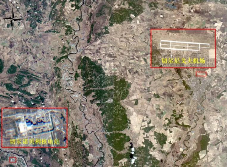
Images of ukraine and interpretation results of the Chernobyl nuclear power plant obtained by the AirFast platform (Source: Zhongke Satellite Company)
(2) In the attack: target change analysis
The analysis of reconnaissance target changes is a comparative analysis method based on multi-time imagery of the same target, which is the basis for target tracking and monitoring, analysis and judgment of its development and change trend, and can play an important role in the deployment of military targets, battlefield reconnaissance and surveillance, strike effect evaluation, emergencies and disaster relief.
In the current Russo-Ukrainian War, a satellite image obtained through the "HiSilk-1" SAR remote sensing satellite on the evening of the 27th local time showed that the runway of the Vinnytsia Air Base suffered fire.

Ukrainian runway acquired by Hiser-1 (Source: Celestial Research Institute)
(3) In the attack: dynamic surveillance of important targets
The use of remote sensing satellites can find the vast majority of military targets: artillery, aircraft, vehicles and other single weapons and equipment, but also closely track the situation and changes between the enemy and us in the course of the development of war.
For example, the SAR remote sensing satellite obtained by the "HiSilk-1" can be seen that there is a large-scale Russian military convoy assembling near the airport about 1 km.
Antonov Airport (30.198E, 50.601N) (Source: Institute of Celestial Instruments)
(4) After the blow: effect evaluation
After the strike, the use of remote sensing satellites to assess the strike effect of the target can not only reduce the depletion of expensive and precision strike weapons caused by repeated strikes, but also organize new strikes when the strike does not achieve the desired effect, completely destroy the target, and determine the target for follow-up strikes.
2. Military surveying and mapping applications
Military mapping applications include coordinate positioning of target areas and acquisition of operational maps.
In order to ensure the navigation error of aircraft, submarines, missiles and other important military equipment and the accuracy of long-range weapons hits, aerospace remote sensing technology is used to carry out accurate geodetic surveys, so as to establish a global unified coordinate system and measure the topographic map of the target area, ensure that decision-makers understand the geographical situation of the theater, grasp the terrain of the battlefield, and correctly use the terrain and technical weapons in combat and training to accurately locate and give full play to the shooting efficiency.
3. War potential assessment
War potential assessment is the use of remote sensing satellites to carry out battlefield resource surveys and war potential assessments.
For example, before the start of the war, remote sensing satellites were used to survey and map the terrain, roads, bridges, power stations, metallurgy, machinery, petroleum, chemical industry, communications, farmland, water conservancy, and other combat support facilities of the belligerent countries, and to estimate the comprehensive strength of the opponents, so as to deduce their durability in the war, so as to know themselves and each other, and strive to never lose a hundred battles.
4. Wartime meteorological support
There are many factors that affect war, and weather is one of them.
Modern warfare is a multi-service joint operation, which requires integrated and coordinated operations of land, sea, air, space, and electricity. Meteorological conditions such as wind speed, wind direction, precipitation, temperature, waves and clouds have a greater impact on the performance of weapons and equipment such as ships and aircraft. The use of meteorological satellites to carry out accurate forecasting of wind, clouds, rain, fog and other weather in the areas where the war occurs, to provide reliable meteorological support for the troops, to help the formulation of bombing plans and the timing of satellites to shoot specific targets.
(2) Shortcomings in the application of satellite remote sensing in modern warfare
1. The current number of remote sensing satellites in orbit "looks like more, less to use"
In recent years, with the completion of a number of civil and commercial remote sensing satellite systems at home and abroad, the shortage of remote sensing satellite resources and the monopoly of remote sensing data sources in Europe and the United States have eased to a certain extent. But in military applications, it is far from "easy to use" and "enough".
By combing the resources of more than 300 remote sensing satellites at home and abroad, most of the more than 300 remote sensing satellites are not suitable for use under the influence of spatial resolution, revisit cycle, transit time and complex environment penetration ability, and under most military application scenarios, subject to various conditions. Concentrated in:
Most of the satellites are in the morning, and fewer stars are available in the afternoon;
Optical satellites are the mainstays, lacking the payloads required for military applications such as radar, infrared, and low light;
Secondly, satellite management is scattered, the efficiency is not fully exerted, and there is a lack of a unified military-civilian emergency response mechanism, and it is difficult to coordinate observation.
In general, the objective status quo is that the number of available satellites is small, and satellites in orbit lack coordination, sharing and operation management mechanisms, resulting in insufficient effectiveness of satellites in orbit in military applications.
2. The timeliness of remote sensing satellites limits the development of military application scenarios
At present, a small number of remote sensing satellites using geosynchronous orbit can achieve 24-hour uninterrupted observation and real-time transmission of data to a specific area, but due to the high altitude of the orbit, such remote sensing satellites have low resolution (resolution is mostly in the 100-meter level) and are expensive.
Most remote sensing satellites use low orbits, such as sunsynchronous orbits. Due to the low distance from the ground, it is easy to achieve high-resolution Earth observation effects with low-cost payloads (for example, optical or radar imaging techniques for sub-meter-level small satellites in low orbit are very mature). However, due to the fact that low-orbit satellites are in relative motion with the Earth at high speeds, in the absence of effective space data transmission networks, satellite ground stations must be relied upon for data reception. Therefore, the global distribution and networking of ground stations determine the real-time nature of data reception.
Due to restrictions such as site construction conditions and international network communication conditions, there is a significant delay (usually in the hourly level) in the data backhaul of remote sensing satellites in military applications. At the same time, due to the limitations of satellite revisit capabilities, conflicting observation needs and observation conditions, the frequency of observations for designated areas is often measured in days, weeks and months, so that remote sensing applications always need to use past data (archived data) to solve current problems.
The lack of effective supply of real-time remote sensing data has become the main bottleneck in the application of new remote sensing military scenarios.
3. The processing performance of remote sensing satellites restricts the service level of military applications
In the field of remote sensing satellites, the main purpose of giving play to military reconnaissance capabilities is to obtain military intelligence, and constantly pursue many strict standards and requirements such as timely accuracy, clarity and intuitiveness, safety and reliability. When civilian or commercial technical equipment is applied to the military field, it is also necessary to meet such standard requirements.
However, at the application level, most of the civil and commercial remote sensing satellites are processed after receiving and obtaining accurate intelligence; secondly, for the reconnaissance of important military targets and the assessment of the battle situation, the basic geographic information products generated by automatic interpretation and extraction algorithms still need to be manually proofread and corrected, and the level of intelligence and automation needs to be improved, and the lack of real-time data processing capabilities on the basis of limited satellite energy is difficult to meet the military application needs of modern warfare.
Third, the value and effectiveness of real-time remote sensing satellites in modern warfare
Instant remote sensing satellites refer to remote sensing satellites that can achieve minute-level revisits of any target in the world and hourly acquisition of remote sensing data in any region; generally include visible light, SAR, thermal infrared, hyperspectral, low-light and other types of payloads; usually integrate a variety of high-tech technologies such as intelligent processing on the satellite, inter-satellite chain communication or high-orbit communication, data distribution of space-earth fusion, breaking the data sharing barriers between the original satellites, and enabling the comprehensive and efficient utilization of various resources such as orbit, sensors, and communications.
Real-time remote sensing satellites can not only provide integrated reconnaissance, navigation, combat command and other services, but also provide all-round and real-time support for sea, land and air communications, navigation, emergency rescue, weather forecasting, etc., making it possible to cross-dimensional military application services such as sea, land and air.
(1) The military value of real-time remote sensing in modern warfare 1
Precision missile warfare requires information support for surveying and mapping support. At present, the surveying, mapping and support information required for precision guidance weapons is prepared on a regular basis in the combat readiness stage, with a long cycle and low support efficiency. In the face of future combat scenarios such as multi-weapon cluster strikes and multi-wave attacks, the pre-war stage needs to quickly update the surveying and mapping support information required for precision guidance weapons in real time to meet the needs of complex and real-time changes in the future battlefield environment. The use of real-time remote sensing satellites can provide rapid update of precision digital maps, refined construction of three-dimensional models of buildings (with texture), DSM/DEM automated rapid production, etc., so that the construction of target three-dimensional scenes, while there are multiple data sources to support, the timeliness and accuracy are higher, and the long-range precision information support capabilities and precision guidance weapons combat effectiveness are improved.
2. Battlefield support
Whether it is long-range precision combat of precision-guided weapons or joint operations of services and arms, it is necessary to provide support for accurate and real-time battlefield environment and battlefield situation information.
At present, battlefield threat intelligence is mainly based on historical static information support, and the efficiency of battlefield environment situation update is low, especially for the threat analysis of mobile targets is lagging behind, and it is impossible to update dynamically in real time, which is basically in a state of "statelessness".
In the complex environment of the battlefield, the change of target state and the scene of tactical aircraft adjustment, the rapid reconnaissance capability of real-time remote sensing is used to update the battlefield environment and situation changes in quasi-real time, providing decision-making reference and targeted support for the tactical deployment of combat commanders, tactical temporary adjustment, and precision guidance weapon penetration.
3. Target Guarantee
For the multi-dimensional characteristic analysis of enemy targets, at present, most of them are mainly based on simulation, and there is a lack of real and reliable measured data to verify the simulation model.
Using the multi-type sensors equipped with real-time remote sensing, we will continue to conduct long-term reconnaissance of the enemy's key targets, accumulate characteristic data results, form a multi-dimensional characteristic data set of the target, and carry out electromagnetic scattering, infrared and other characteristic analysis of enemy targets, so as to provide basic support for the operation of the whole army's precision guided weapons.
Among them, radar satellite detection can be used to reconnoiter the electromagnetic scattering characteristics of targets; hyperspectral satellite reconnaissance can identify enemy camouflage targets, reverse target materials, and analyze vulnerable parts; infrared satellite reconnaissance can obtain the infrared characteristics of targets.
4. Strategic early warning
At present, there are problems of long warning time, insufficient precision and low positioning accuracy in strategic early warning.
Real-time remote sensing uses early warning, tracking and real-time data backhaul capabilities, combined with multi-domain reconnaissance means, to support, guide reconnaissance and information fusion, and provide richer elements and more accurate positioning for strategic early warning.
In the face of enemy strategic bombers, missile weapons and other key targets, in addition to discovering the enemy's position, real-time remote sensing satellites can more accurately locate target types and threats, analyze their operational intentions and trajectories, and achieve multi-dimensional cognition of strategic early warning targets.
(2) Analysis of the effectiveness of real-time remote sensing in modern warfare 1. Real-time transmission and integration of reconnaissance and combat
Real-time battlefield information is a prerequisite for the army to carry out combat operations, using the advantages of real-time remote sensing quasi-real-time, wide coverage, multi-payload, multi-spectrum segment, high intelligence, etc., combined with other reconnaissance means can transmit the intelligence obtained at that time to the command center and weapon strike system in real time or near real time, integrate the application service of the real-time remote sensing satellite with long-range, high-precision, and high-powered destructive weapons. The response time between decision-making and strike realizes a seamless link from sensor to shooter, ensuring military reconnaissance and combat.
2. Full-time operation, multi-spectrum interception
The military reconnaissance means of real-time remote sensing satellites have reconnaissance and surveillance capabilities for all-weather, all-weather, camouflage identification and real-time transmission. Workers can observe scrolling images of satellite coverage indoors, or they can record at high speeds, achieving immediate perception of the battlefield situation.
Radar imaging satellites can penetrate clouds, overcome rain, snow and night darkness, even in bad weather, can still clearly monitor the movements of enemy ground troops, carry out all-weather reconnaissance, and ensure accurate strikes against enemy troops.
In the reconnaissance of the electronic spectrum, the emergence of multi-spectral, hyperspectral, infrared, low-light and other types of remote sensing devices carried by the real-time remote sensing satellite has enabled the military to have the ability to intercept the multi-spectrum of electromagnetic waves.
3. Full-dimensional reconnaissance, the effectiveness is prominent
In the modern battlefield, real-time remote sensing satellites can play the advantages of all-dimensional deployment. Not only can we monitor every action on the battlefield from different spaces and different perspectives, and avoid blind spots in "perspective," but we can also learn from each other's strong points and other reconnaissance techniques, complement each other, certify each other, enhance the reconnaissance capabilities of the battlefield, and analyze the authenticity of intelligence from the all-round and large-depth intelligence information received.
In terms of fixed and mobile multi-dimensional target reconnaissance, the use of real-time remote sensing satellites can quickly access the characteristics of any target point in the world, carry out dynamic eye information on land-sensitive targets, land-based fixed targets, and maritime mobile targets, and long-term continuous tracking and monitoring, once any satellite detects the target, through low-orbit satellite inter-satellite chain or high-orbit communication, coupled with the grid data distribution means of intelligent data processing and space-to-earth integration on the satellite, to achieve rapid data backhaul, up to minute-level rapid revisit efficiency, Meet the requirements of military applications with fast response and remote sensing images "out of the box".
Fourth, the outlook
With the rapid entry of artificial intelligence, human-machine collaboration, big data and other technologies into the battlefield, as well as the rapid rise of satellite spatial resolution and revisit capabilities, in the context of the future complex battlefield, the demand for remote sensing data for a new generation of weapons and equipment will inevitably produce explosive growth. Therefore, coordinating military and civilian satellite resources, building a space-based real-time monitoring system for hundreds or even thousands of satellites, and real-time dynamic monitoring of moving targets and battlefield environments will become the mainstream development trend of military applications. In its future development, military intelligence services will focus on the use of automation and artificial intelligence technology, expanding data sources, and enriching real-time military application products, and provide intelligent military services at a lower cost and in a shorter cycle to supplement, guarantee and meet the military's ability needs for satellite remote sensing in modern warfare.