From the perspective of weather and climate, most of China's regions in 2021 will start from abnormal extreme weather and climate events. The bitter cold wave at the beginning of 2021 is still fresh in many people's minds, but the winter of 2020/2021 is a warm winter.
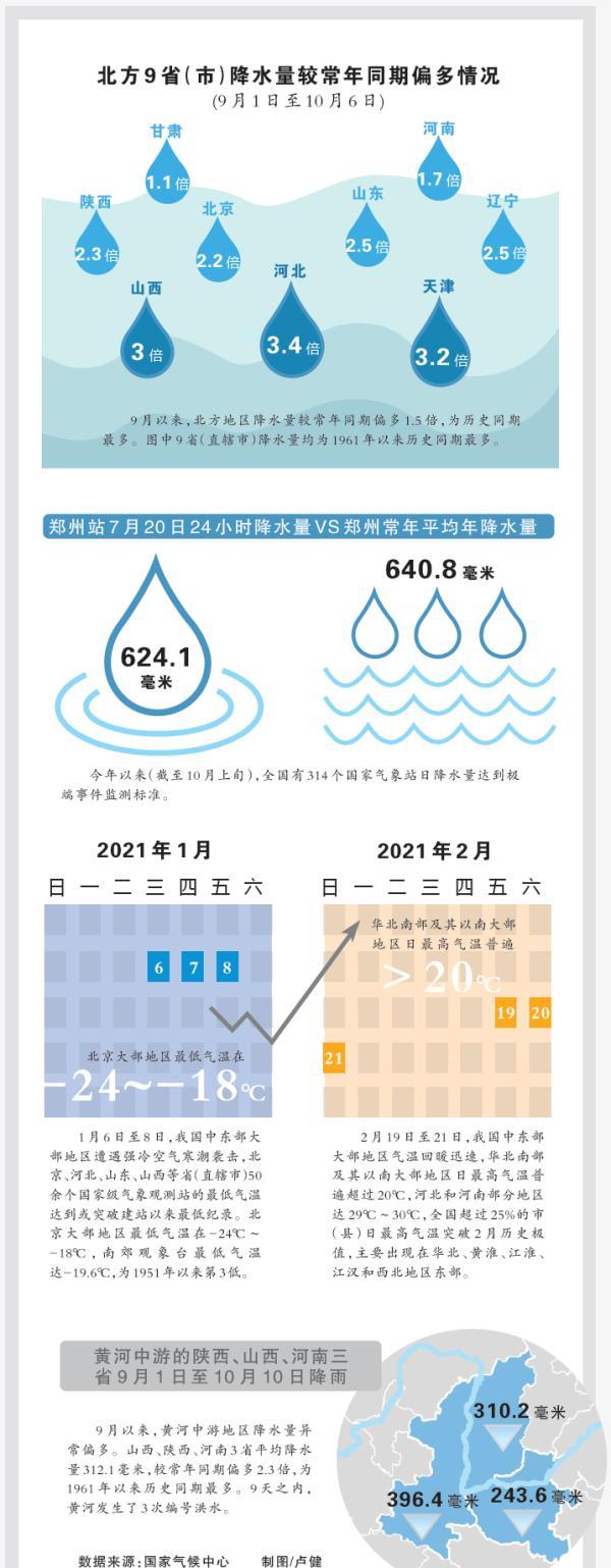
Almost every month since then, there have been extreme weather - in the spring, the north encountered a rare strong sandstorm in the past 10 years; from April to September, there were 17 tornadoes of moderate intensity or above in China, exceeding the annual average; in July, the maximum hourly rainfall in Zhengzhou exceeded the historical extremes of China's inland region; from September to early October, the precipitation in the northern region was the most since 1961...
Not only in East Asia, extreme events are frequent in many parts of the world. In mid-February, winter storm "Uri" hit most of North America, and temperatures in many places broke through historical extremes; in June, under the blessing of a rare high temperature heat wave, 49.7% of the western United States experienced "extreme" droughts; in July, 24-hour precipitation in parts of Germany reached 100 mm to 150 mm, resulting in at least 179 deaths...
This year
On the stage with global warming as the main tone
"Pandora's Box" of Extreme Weather
Is opened frequently
All this
How is the connection made?
Extreme weather and extreme climates:
Not the same thing, but tangled
Extreme weather events and extreme weather events are two different concepts. Although we often associate the two together, their formation mechanisms are different.
What are extreme weather and climate events?
Extreme events are generally defined as the values of a certain weather or climate variable that occur beyond a threshold. The threshold is often taken to a value near the high (or low end) of the variable (such as ≥2σ or 3σ), and the probability of occurrence is generally less than 10%.
Certain climatic extremes or events can be the result of the accumulation of multiple weather or climatic events, and each event itself may not be extreme. i.e. individual processes are not extreme, while their cumulative results are extreme and continuous.
Assuming that extreme weather events are likened to rolling dice, some extreme weather events, mainly caused by internal activities in the atmosphere, have a strong randomness, such as strong convective weather with very small scales. On April 30 this year, Jiangsu Along the Yangtze River and its northern part of the country suffered strong convective weather such as strong winds and hail, and the maximum wind speed in some coastal areas of Nantong reached 47.9 m/s (15 levels); on May 14, Suzhou and Wuhan had strong tornado weather on the same day, and on-site disaster investigation and analysis showed that the maximum wind strength could reach more than 17 levels.
There are also some extreme weather events, the occurrence of which is related to interannual changes in the climate system and long-term changes in climate (such as global warming). In the favorable background field provided by the latter, the statistical characteristics such as the frequency, intensity, and range of extreme weather events have changed. What is more obvious is that the global warming trend makes the temperature of each season increase year by year, resulting in an increase in extreme weather events such as extreme heat waves, heavy rains and strong typhoons in summer.
Because of the long duration of extreme weather events, in general, the role of external factors is larger, such as sharp changes in temperature at the beginning of this year and the postponement of autumn, early arrival of cold waves, etc., all of which are related to global warming.
But often, because the climate system itself is a complex, highly non-linear, open giant system, whether it is an extreme weather event or an extreme climate event, it is the result of the interaction of multiple complex factors. A team of experts has spent more than two years to basically study a rainstorm case in Guangzhou, and its complexity can be seen.
global warming:
Breeding a hotbed of unstable events
When discussing most extreme weather and climate events, global warming is an important context that cannot be ignored.
According to the Report of Working Group I of the Sixth Assessment Report (AR6) of the Intergovernmental Panel on Climate Change (IPCC), the average temperature rise in 2011-2020 increased by 1.09°C compared to pre-industrial (1850-1900) and the average temperature rise in 2001-2020 increased by 0.99°C compared to pre-industrial. The climate is warming rapidly, and this warming is global. Global warming is not only raising global temperatures, but also dramatically changing the climate system that is closely related to us. Rolling the "extreme event" dice in this chess game, although the dice roll itself is a random event, the frequency of the dice roll has changed.
Taking extreme heat events as an example, the frequency and intensity of extreme heat events in most parts of the world have increased since the 1950s, which has been confirmed by multiple reports and data.
The effects of rising temperatures soon spread to the Arctic. Due to the "Arctic amplification effect", the loss of Arctic sea ice, the melting of the Greenland ice sheet, and the frequency and intensity of events such as heavy precipitation, inland flooding, coastal erosion and wildfires are increasing. The latest observations released by the Arctic Monitoring and Assessment Programme Working Group on May 20 this year show that rapid and widespread change is taking place in the Arctic, with the Arctic warming three times faster than the global average between 1971 and 2019, higher than previous observations. As a "key point" affecting the Northern Hemisphere, changes in the Arctic affect the global climate through feedback effects from the climate system. We have seen its unique impact in many extreme cold and warm events around the world this year.
As the primary "heat reservoir" of the Earth's climate system, the rate at which the oceans have warmed has doubled since the early 1990s. Behind many extreme cold and warm events and extreme heavy rainfall, it is inseparable from the "fueling" of the ocean. For example, the tropical Indian Ocean - South China Sea - Central and Western Pacific region of the sea temperature warming faster, evaporation of water vapor sources increased, in the same atmospheric circulation situation, is conducive to transporting more water vapor to the land, the formation of a strong precipitation event. In addition, ocean warming will also make stronger typhoons/hurricanes, and the decay rate after landfall will be slower and last longer, and this year's "chronic sub-typhoon" "fireworks" is a typical example.

For example, a pool of warm water slowly begins to boil, constantly bulging out large blisters, which seem to be accidental and inevitable. In addition to the Arctic and the oceans, global warming has exacerbated variables, and its effects are quickly apparent in extreme events. Extreme weather and climate events that used to be "once in decades" or even "once in a century" seem to be becoming more common.
Extreme cold and warm events:
Tight westerly wind bands become prone to fluctuations
Since the beginning of this year (as of September 26), the average temperature in China has been 12.8 °C, which is 1.2 °C higher than the same period of the year, reaching the highest in the same period of history since 1961. In the winter of 2020/2021, the average temperature in China is -2.5 °C, which is 0.8 °C higher than the same period of the year (-3.3 °C), and the eighth highest in the same period of history since 1961.
Extreme cold and warm events at the beginning of this year were staged on this curtain. This is not an isolated case, as the winters of 2015/2016 and 2018/2019 also experienced simultaneous extreme low temperatures and extreme heat events. This is closely related to the thermal effect of global warming and the dynamic effect of the Arctic amplification effect.
China is in a monsoon climate zone, and winter winds blow from the cold continents in the north to the warm oceans in the south. The thermodynamic effect of global warming itself favors rising surface temperatures and an increase in extreme warming events.
However, due to the amplification effect of the Arctic, the temperature gradient in the middle and high latitudes has decreased, and the westerly wind over Eurasia has weakened. The west wind belt is like a leather band, in the past the west wind belt was strong, this leather band was relatively tight, and the meridian gradient was small, but now the leather band is relaxed, and the warp gradient has become larger, so it is conducive to the occurrence and maintenance of the Ural blocking event. On the other hand, weakened westerly winds and strengthened high pressure ridges in the Ural region favor the strengthening of Siberian high pressure. As a result, the cold advection in East Asia has been significantly enhanced, which is conducive to the emergence of extremely low temperature events.
During the Arctic amplification period, the extreme cold and warm events in East Asia increased at a similar rate, the temperature variability increased, and the average seasonal temperature changed almost unchanged. This means that even during periods of global warming, the likelihood of extreme cold and warm events in East Asia is increasing.
Extreme precipitation events:
Subtropical high pressure is not the usual path
In the summer half of the year, as the sun begins to shine directly into the northern hemisphere, East Asia enters the hottest half of the year. China is not only affected by the tropical monsoon, but also by the subtropical monsoon, and the superposition of the two monsoons has aggravated the uncertainty of weather changes in China. After the arrival of the southwest monsoon, it is easy to generate a variety of stranded fronts, often with tropical cyclones generated by the ocean, and thunderstorms generated by hot convection in the afternoon, with a significant increase in rainfall and heavy rain from time to time.
This year, the most important weather and climate system in East Asia, the subtropical high pressure, has shown characteristics such as strong intensity and west-north location. It is precisely because of its abnormal performance that the area under its control has maintained sunny and high temperature weather for a long time, and a water vapor channel has been built in its north, and heavy precipitation has also appeared in its northern and northwestern regions, which can be described as "flame" on one side and "sea water" on the other.
The heavy rainfall in Henan in July this year reflects the complexity of the multiple factors behind the occurrence of extreme events. First of all, climate warming exacerbates the instability of the climate system, which is the global background that causes the frequent occurrence of extreme weather and climate events; "seven down and eight up" is in the concentrated period of precipitation in the northern region of China, providing a climatic background for the occurrence of extreme heavy precipitation. At the same time, in July, the subtropical high pressure in the western Pacific Ocean was strong and northward, extending west to the east of North China and the east of Huanghuai, and Henan was on the western edge of the sub-high, with unstable convection and sufficient energy. Typhoon activity in the tropics has also entered a period of frequent occurrence, and Typhoon No. 6 "Fireworks" has developed simultaneously in the northwest Pacific Ocean and Typhoon "Chapaka" in the South China Sea, strengthening the transport of water vapor from the northwest Pacific Ocean, the South China Sea and the Bay of Bengal, providing an abundant source of water vapor for heavy rainfall in Henan. The special terrain of Taihang Mountain and Funiu Mountain has an uplifting and radiation effect on the easterly air flow, and the special terrain further enhances the extreme nature of precipitation.
Generally speaking, when the La Niña phenomenon appeared, the Pacific Ocean was cold in the east and warm in the west, and the warm water in the western Pacific ocean was conducive to the development of tropical convection, enhancing the energy of the tropical convergence zone. This convergence zone is the main, long-lasting, planetary-scale large-scale weather system in the tropics, and its generation, dissipation, movement and change have a great impact on the long-term, medium-term and short-term weather changes in the tropics. At the same time, the tropical convergence belt boosts the northward position of the subtropical high pressure through the action of the meridian circulation. (For the latest projections of La Niña and its interpretation of the global and Chinese implications, click on the link "Official Announcement!) The La Niña Incident will take shape! Will our country be cold this winter? 》)
In addition, since the autumn, the abnormal precipitation in northern China is also caused by the combined effect of the continuous northerly subtropical high pressure in the western Pacific Ocean and the cold air activity at the middle and high latitudes.
Extreme weather and climate events this year
Not only does it break a lot of historical extremes
It also makes more and more people aware
This year's events are by no means isolated
Something similar will happen later
More areas
More compound extreme events will be encountered
Produced by China Meteorological News
Author: Li Hui Zhao Xiaoni Lu Jian
Expert Consultant: Zhou Bing, Chief Expert of Climate Services of the National Climate Center
Yu Yongqiang, a researcher at the Institute of Atmospheric Physics, Chinese Academy of Sciences
Professor Luo Jingjia of Nanjing University of Information Science and Technology
Source: China Meteorology