China Weather Network News Today (January 19), most parts of the mainland received less precipitation. From tomorrow to the 24th, there will be a large-scale rain and snow process in the central and eastern regions, and it is necessary to pay attention to prevention.
First, the national weather situation
Yesterday (January 17), most parts of the country received less precipitation. This morning, there was heavy fog with visibility of less than 1 km in parts of southeastern Hebei, north-east shanxi, central and eastern Henan, north-central Anhui, western Jiangsu, Hubei, northwestern Jiangxi, Hunan, southeastern Guizhou, western Sichuan Basin, and northern Guangxi, with local visibility of less than 200 meters.
Second, the national weather forecast
There will be a widespread rain and snow process in the central and eastern parts of the continent. On the 19th, most of the mainland has less precipitation; from the 20th to the 24th, there will be a large-scale rain and snow process in the central and eastern regions, with small to moderate snow or sleet in the Qinghai-Tibet Plateau, the central and eastern parts of the northwest region and parts north of the Huai River, and heavy snow and localized snow in the mountainous areas along the southern part of Shaanxi, southern Shanxi, southern Hebei, Henan, shandong and southern Tibet, with a new snow depth of 5 to 10 cm and a local snow depth of 15 to 20 cm; most of the south has small to moderate rain, and eastern Guizhou, south-central Hunan, central Jiangxi, etc. There is heavy rain in parts of northern and eastern Guangxi, northern Guangdong, northern Fujian and other places, and localized heavy rain.
There is heavy fog in Places such as Hubei and Hunan in Anhui. From the night of the 19th to the morning of the 20th, there was heavy fog in southern Anhui, eastern Hubei, northeastern Hunan and other places, and there was a strong fog with visibility of less than 200 meters. From the night of the 20th to the morning of the 21st, there was foggy weather in northern Jiangsu and other places.
The specific forecast is as follows:
From noon to night on the 19th, there was light snow or sleet in some parts of northwestern Xinjiang, eastern Tibet, southern Sichuan, northwestern Yunnan and other places; there was moderate rain in southern Yunnan.
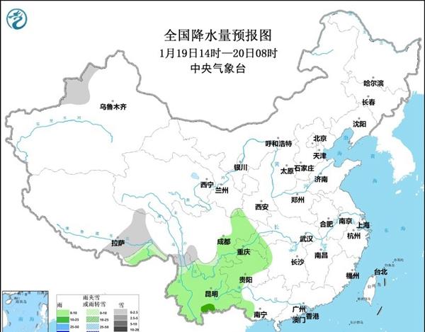
On the 20th, there was light to moderate snow or sleet in parts of northern Xinjiang, southeastern Gansu, southeastern Qinghai, Shaanxi, central Inner Mongolia, Shanxi, western Hebei, western and northern Beijing, most of Henan, shanxi, western Shanxi, Tibet and other places, of which there was heavy snow in Xinjiang Altay and Ili River Valley, western Henan, southeastern Shaanxi and other places; Chongqing, southwestern Hubei, southern Yunnan and other places had moderate rain and local heavy rain.

Third, the weather forecast in Beijing area
It is expected that during the day on the 19th, the Beijing area will be dominated by cloudy weather; from midnight to the morning of the 20th, the weather will turn cloudy, and there will be sporadic light snow or snow in the western and northern regions. During this period, the maximum temperature during the day is -2 ~ -1 °C, and the minimum temperature at night is -8 ~ -6 °C.
Schedule Beijing Weather Forecast (January 19 noon to 20 January)
4. Forecast of high winds and sea fog at sea
From the afternoon of the 18th to the night, the Bohai Sea, the Bohai Strait, most of the Yellow Sea, the south of the East China Sea, the Taiwan Strait, the ocean east of Taiwan, the Bashi Strait, most of the South China Sea and other sea areas will have 6 to 7, gusts of 8 north to northeast winds, taiwan strait winds up to 8, gusts of wind 9.
From day to night on the 19th, there will be east-to-northeast winds of magnitude 6 to 7 and 8 gusts in the southern part of the East China Sea, the Taiwan Strait, the ocean east of Taiwan, the Bashi Strait, the northern and southwestern waters of the South China Sea, and the winds of the Taiwan Strait can reach level 8 and gusts of 9. From the night of the 19th to the morning of the 20th, there will be light fog with visibility of less than 10 kilometers in the Qiongzhou Strait.
Fifth, the national road traffic impact forecast
It is estimated that from noon on the 19th to noon on the 20th, some roads in western Xinjiang, Tibet, Qinghai, western and northern Beijing, western Hebei, eastern Shanxi, western and northern Henan, southern Shaanxi, and southern Gansu will be affected by light to moderate snow or sleet; some roads in central and eastern Sichuan, Chongqing, Yunnan, Guizhou, western Guangxi, northwestern Hunan, and southwestern Hubei will be affected by light rain; and some roads in southern Anhui, eastern Hubei, northeastern Hunan, western Jiangxi, eastern Guangxi, and northern Xinjiang will be affected by fog.
Sixth, the national railway traffic meteorological impact forecast
It is estimated that from noon on the 19th to noon on the 20th, the operation and maintenance of railway lines such as Handan-Anyang on the Beijing-Guangzhou Line, Luoyang North-Baofeng on the Jiaoliu Line, Fengxian-Luoyang on the Baocheng Line, and Haixi-Lhasa on the Qinghai-Tibet Line will be at higher risk of being affected by low temperature freezing and snow.
7. National airport meteorological impact forecast
It is estimated that from noon on the 19th to noon on the 20th, most of the national airports will be airworthy; the low-altitude airspace of the Liaodong Peninsula, Shandong Peninsula, Shaanxi, southern Gansu, Ningxia, eastern Yunnan, northern Guizhou and other places will have light to moderate turbulence; the low-altitude airspace of Beijing, southern Hebei, southern Shanxi, western Henan, Shaanxi, and southern Gansu will have ice accumulation conditions. On the night of the 19th, there was light rain at Chongqing, Guiyang and other airports; on the morning of the 20th, the visibility of Nanchang, Changsha and other airports was about 800 meters, and there was frost at Jinan, Qingdao, Zhengzhou, Taiyuan, Lanzhou and other airports.
8. Forecast of meteorological impact of the Yangtze River trunk waterway
On the afternoon of the 19th, most of the sections of the Yangtze River trunk line in Sichuan, Chongqing, Hubei, Hunan, Jiangxi, Anhui and Jiangsu were affected by fog and had low visibility. Low visibility affects the segment: Yibin-Luzhou, Luzhou-Chongqing, Three Gorges-Yichang, Yichang-Yueyang, Yueyang-Wuhan, Wuhan-Jiujiang, Jiujiang-Nanjing, Nanjing-Jiangyin, Jiangyin-Taicang.
On the night of the 19th, most of the sections of the Yangtze River trunk line in Sichuan, Chongqing, Hubei, Hunan, Jiangxi, Anhui and Jiangsu were affected by fog and had low visibility. Low visibility affects the segment: Yibin-Luzhou, Luzhou-Chongqing, Three Gorges-Yichang, Yichang-Yueyang, Yueyang-Wuhan, Wuhan-Jiujiang, Jiujiang-Nanjing, Nanjing-Jiangyin, Jiangyin-Taicang.
9. Concerns and Suggestions
In the next two days, Anhui, Hubei, Hunan and other places need to guard against the adverse impact of fog on transportation, and the Qiongzhou Strait should guard against the adverse effects of light fog. From the 20th, there will be a wide range of rain and snow in the central and eastern regions, and it is necessary to pay attention to preventing rain and snow and the adverse impact of wet and slippery roads, snow and ice, low visibility and other traffic on roads, railways, airports and so on.