NASA, the United States, and European partner satellites returned and made the first sea level measurements, obtaining new data on sea level.
The U.S.-EU cooperation satellite returns its first sea level measurements
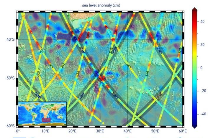
The image shows the first sea surface altitude measurement of the Sentinel 6 Michael Frelich satellite launched on November 21, 2020. The picture shows the ocean at the southern tip of Africa, with red representing areas of high sea level and blue representing areas of low sea level.

Michael Frelich, a joint U.S.-EU satellite built to measure global sea level heights, has sent back its first sea level measurements. These data provide information on sea surface height, wave height and wind speed at the southern tip of Africa.
Thomas Zubchin, deputy director for scientific affairs at NASA's Washington headquarters, said: "We are excited that Sentinel 6 Michael Frelich began to study sea level and help us understand many aspects of the global ocean. I knew Mike would be thrilled by the satellite that had already started running and named after him, and even he would be just as excited as we were looking forward to studying data from this important mission. ”
Since the successful launch of the Space X Falcon 9 rocket at Vandenberg Air Force Base in California on Nov. 21, engineers and scientists have spent weeks getting up and running satellites and related instruments to make sure everything is working properly. Josh Willis, a project scientist at NASA's Jet Propulsion Laboratory, said: "Christmas came early this year, and the out-of-the-box data looks fantastic. ”
Sentinel 6 Michael Frelich will continue decades of efforts from space to measure the height of the world's oceans from space, starting in the early 1990s. Since then, the rate of sea level rise has doubled, with the current rate being 0.16 inches (4 millimeters) per year. This rise is caused almost entirely by a combination of melting water from land glaciers and ice sheets, as well as swelling as seawater warms.
Karen St. Germain, director of NASA's Earth Sciences Division, said: "The data from Sentinel 6 will help us assess how the Earth is changing, and when we combine data from instruments such as the altimeter on Sentinel 6 with data from other satellites such as Grace-fo and On Ice Satellite 2, we can know which sea level rise is due to melting ice and which is due to the expansion of the ocean due to warming." Understanding these potential physical mechanisms allows NASA to improve its predictions of future sea level rise. ”
Sentinel 6's initial orbit, Michael Frelich, was 11.4 miles (18.4 km) lower than its final orbit 830 miles (1336 km) above Earth. Engineers plan to put the satellite into orbit in mid-December, when it will track the Jason-3 satellite at 30 seconds. On this tandem flight, scientists and engineers will cross-calibrate the data collected by the two satellites over the next 6 to 12 months to ensure continuity of measurements between the two satellites. Once the data quality is guaranteed, Sentinel 6 Michael Frelich will become the main sea-level satellite. The first published sea level data will be published in about 6 months, and the rest will be published within a year.
Manfred Luggett, Mission Manager for sentinel 6/Jason cs (Continuous Services) of the European Meteorological Satellite Applications Organization, said: "We are now preparing operating systems that support the European Meteorological Satellite Organization and partner organizations in processing instrument data, and they all contribute to this complex process. This will keep us busy for the next few months, as independent scientific validation and fine-tuning will need to be done with great care. Luggett expects that by mid-2021, the mission's first combat products will be available to those who need them.
In addition to measuring sea level, Sentinel 6 Michael Frelich is also monitoring atmospheric temperature and humidity, which will help improve weather and hurricane forecasts. Engineers and scientists opened the instrument on Nov. 27, and the initial data looked good.
More about the task
Sentinel 6 was named in honor of the former director of NASA's Earth Sciences Division, a leading figure in advancing ocean observations in space. Frelich passed away on August 5, 2020. "I think he'll be proud, like Mike himself, and we're looking forward to what this satellite named after him will bring about something great," Willis said. So far, it looks pretty good. ”
The spacecraft is one of two identical satellites that will extend nearly 30 years of sea level records collected by U.S. and European satellites for another 10 years. This record began with the topex/poseidon satellite in 1992, following Jason-1 (2001), OSTM/jason-2 (2008) and Jason-3, which began observing Earth's oceans in 2016. "Sentinel 6" Michael Frelich will pass the baton to its twin brother "Sentinel 6b" in 2025.
Both spacecraft are part of the Sentinel 6/Jason CS mission, which will collect accurate sea surface altitude measurements of more than 90 percent of the world's oceans. The satellite will also monitor atmospheric temperature and humidity, as well as wave height and wind speed, which will provide key information for practical oceanography, marine meteorology and climate studies.
ESA, the European Meteorological Satellite Organization, NASA and the National Oceanic and Atmospheric Administration have jointly developed the Sentinel 6/Jason Cs mission, funded by the European Commission and supported by the Centre nationale d'étude spatiales of France, which is part of Copernicus, an EU Earth observation project managed by the European Commission.
NASA's contribution to the Sentinel 6/Jason CS mission is that both satellites have three scientific instruments: an advanced climate microwave radiometer, a GNSS-radio occultation, and a laser reflector array. NASA also provides launch services, ground systems that support the operation of NASA's scientific instruments, scientific data processors for two of the instruments, and support for U.S. members of the International Ocean Surface Topography Science Group. NASA's Jet Propulsion Laboratory at the California Institute of Technology in Pasadena manages the agency's contribution to the mission.
Author: sean potter
fy: Mary
If there is any infringement of the relevant content, please contact the author within 30 days to delete it
Please also obtain authorization to reprint, and pay attention to maintaining completeness and indicating source