Seabed landforms
Seamounts – the oceanography in the oceans and oceans, is more similar to the landforms on the continents. There are high mountains and mountains on the seabed, there are also rolling hills, and even Kashman landforms, which are similar to the Guilin landscape in China, but it is difficult for ordinary people to peek into the beautiful underwater scenery.
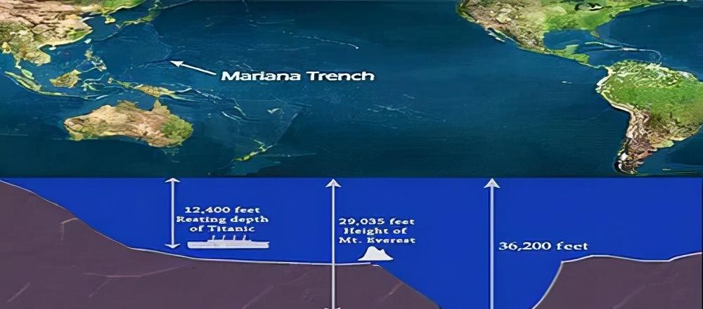
We know that the mountain stream between the two mountains is called a canyon, and the two "seamounts" in the ocean are called trenches, such as the Mariana Trench in the Pacific Ocean, which has a depth of more than 11,000 meters.
Seamounts are rocky mountains protruding from the ground on the seabed, with a certain height in nature! In the ocean, the sea is permanently exposed, and the larger area is called land, and the five continents in the world are giant islands surrounded by the sea on all sides!
But in the ocean, the sudden, surrounded by water on all sides is called islands, and the big islands are called islands, such as Taiwan Island, Hainan Island, and Chongming Island.
In principle, the names of the islands in China from north to south are: the nearby areas of Jiaozhou Bay in the Bohai Bay are called "islands", such as BeichenghuangDao, Snake Island, Xiaoping Island, Sanshan Island, Chaolian Island, and Huangdao Island.
The islands near the mouth of the Yangtze River are called "mountains", such as Sheshan Mountain, Flower and Bird Mountain, Euphorbia Mountain, Putuo Mountain, and Zhoushan Mountain.

Flower and Bird Mountain at the mouth of the Yangtze River
Smaller ones are called "reefs", such as the sea reefs in the sea off Zhoushan Mountain and the chicken bone reefs on the Yellow Sea side of the Yangtze River estuary.
In the Taiwan Strait, it is also called an island, such as Jiangshan Island, Nanpeng Island, and Kinmen Island. However, along the Fujian coast, it was immediately mixed with the islands, such as Qixing Island, Gulangyu Island on the edge of Xiamen Island, Monkey Island and so on.
To the coast of Guangdong, you will use continents, such as Sampan Chau in the Pearl River Waterway, and Qingzhou in Victoria Bay in Hong Kong.
Sea protrusions can be divided into several types: those that are exposed to the sea but do not enter the water after the high tide are called "suitable flood reefs", those that protrude underwater but are never exposed at the lowest sea level are called "reefs", and US nuclear submarines are probably hit reefs.
In most of the world's oceans, humans have all gone into the "sweeping sea" and drawn up charts for navigation. But there are also reefs that have just grown out of crustal movement, but have escaped the sea sweep or have not yet swept the sea.
In particular, the waters of the South China Sea are complex archipelagos, such as the Paracel Islands, the Nansha Islands and the Dongsha Islands.
Most of these tropical reefs are coral reefs, and some of them are still exposed to the water after the high tide, but they are very small, which is called "dry out of the reef".
Because of human activities and the evolution of the earth's crust, it has become an underwater "ghost reef".
Due to the long-term time difference caused by the change of geographical location, the crew of the US imperialist warship is unbalanced when the clock is adjusted, and the body life clock is unbalanced, and it is very easy to cause body fatigue.
Submarines have been engaged in unseemly things for a long time underwater, so the psychology has always been in a state of nervous fatigue, looking at duty during the voyage, positioning is not concentrated, and the area outside the territory is not peaceful, so it has been prominent, but it has not been marked on the (electronic) chart "seamount" neglect.
Of course, when US imperialism makes trouble in the South China Sea, it will kill itself if it commits many acts of injustice. [Squinting smile] [Squinting smile]