China Weather Network News Three days from today (October 30 to November 1) the southern rainy weather will continue, Qinghai, Gansu, Xinjiang parts of the snowfall, local heavy snow. During the intermittent period of cold air, fog and haze in some parts of North China, Huanghuai and other places will take advantage of the opportunity to develop, and tomorrow the haze weather will gradually weaken and dissipate, and the northeast region will also have a significant cooling.
Heavy rain in the south continues To guard against fog and haze in places such as Huanghuai in Northern China
In the recent month, the southwest region has frequent rain and sunshine is scarce, and yesterday the rain also expanded to Jiangnan, South China and other places, and the live monitoring data showed that moderate or heavy rain occurred in parts of southeastern Yunnan, southeastern Guizhou, southern Hunan, southwestern Jiangxi, northern Guangdong, central and northern Guangxi, eastern Hainan Island, and other parts of The rain in Yongzhou, Guangxi, Nanning, Chongzuo, Yunnan, Wenshan and other local areas.
The Central Meteorological Observatory predicts that in the next three days, there will be light to moderate rain in the eastern and southern parts of the southwest region, the central and western parts of Jiangnan, and southern China, among which there will be heavy rain and localized heavy rain in parts of southern Hunan and north-central Guangxi.
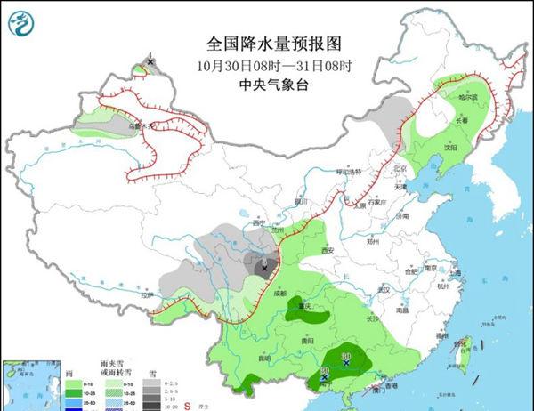
In the next three days, there will be small to moderate snow or sleet in parts of northeastern Tibet, eastern and southern Qinghai, southwestern Gansu, western Sichuan Plateau, northern Xinjiang and other places, and heavy snow or blizzard in the high-altitude areas of Altay in Xinjiang. At the same time, there will be light rain and snow in north China, eastern Inner Mongolia and northeast China, and the intensity is not strong. Today's rain and snow are mainly concentrated in the easternmost part of central Inner Mongolia and most of the northeast region, and tomorrow it is mainly concentrated in the eastern part of the northeast region.
During the intermittent period of cold air, fog and haze also take advantage of the opportunity. Today, the atmospheric diffusion conditions in central and southern China, Huanghuai, Jianghan and other places are poor, with light to moderate haze, of which parts of Tianjin, central and southern Hebei, shanxi and northern Henan have severe haze. From the early morning of tomorrow, affected by cold air, the haze weather in north China, north central Huanghuai and other places gradually weakened or dissipated from north to south, and there was still light to moderate haze and local severe haze during the day on the 31st in Jianghan and southern Huanghuai.
At the same time, from this morning to morning, there was heavy fog in parts of western Liaoning, southeastern Beijing, Tianjin, eastern and south-central Hebei, north-west Shanxi, northern and southern Henan, central Jiangsu, central Hubei, northern Hunan, and southeastern Sichuan Basin, among which there was a strong fog with visibility of less than 200 meters in western Liaoning, southwestern Tianjin, southeastern Hebei, north-west Shanxi, southern Henan, central Hubei, and southeastern Sichuan Basin. From this night to tomorrow morning, there is heavy fog in parts of southern Hebei, central and western Shandong, central and eastern Henan, north-central Suwan, and southeastern Sichuan Basin, and there is a strong fog with visibility of less than 200 meters.

The temperature in the northeast will "dive" The coolness in the southwest and other places is obvious
Today, temperatures in most parts of the country will remain at normal or high levels, but starting on Sunday, under the influence of cold air in the north, the temperature will fall, and there will be a general cooling of 4 °C to 8 °C in the central and northeastern regions of Inner Mongolia. This cold air focuses on the northeast region, where the highest temperature will drop from about 15 °C to single digits, and the minimum temperature will drop from around 5 °C to below freezing. For example, Harbin, Changchun, Shenyang, today's maximum temperature is around 15 °C, tomorrow quickly fell to single digits.
From November 4 to 5, strong cold air will affect the northern and eastern parts of Xinjiang, and from November 6 to 7, cold air will move east to affect most of the central and eastern regions. Affected by it, parts of northern Xinjiang, eastern Northwest China, northern North China and northeast China have small to moderate snow (rain) or sleet, and local heavy snow or blizzard; parts of Jiangnan, South China and the eastern part of Southwest China have light to moderate rain; most of the above areas have 4 to 6 northerly winds and gusts of 7 to 8 degrees, the temperature will drop by 4 to 8 °C, and the cooling range in some areas can reach 10 to 12 °C. However, due to the long time limit, the public still needs to pay attention to the approaching forecast.
In the south, in the coming week, as the rainfall gradually increases and strengthens, the temperature will mostly turn to a lower level than the same period of the year, and the maximum temperature in Jiangnan, southwest and other places is less than 20 °C. In particular, the temperature in many places in the eastern part of the southwest region continues to be depressed, and the maximum temperature in Guiyang and Chengdu in the coming week will be around 15 ° C, and the feeling of coolness is the most significant.
Source: China Weather Network