The old Beijing flyover, which has disappeared for nearly 90 years, has now found the exact spatial location! Recently, the Beijing Municipal Institute of Surveying and Mapping Design and Research revealed that with the continuous advancement of the application for heritage on the central axis of Beijing, after exploration, the original site of the flyover has been basically confirmed. The results of this exploration will be stored in the application file as thematic information, which is of great value for accurately restoring the remains of the flyover and enriching the heritage points of the South Central Axis.
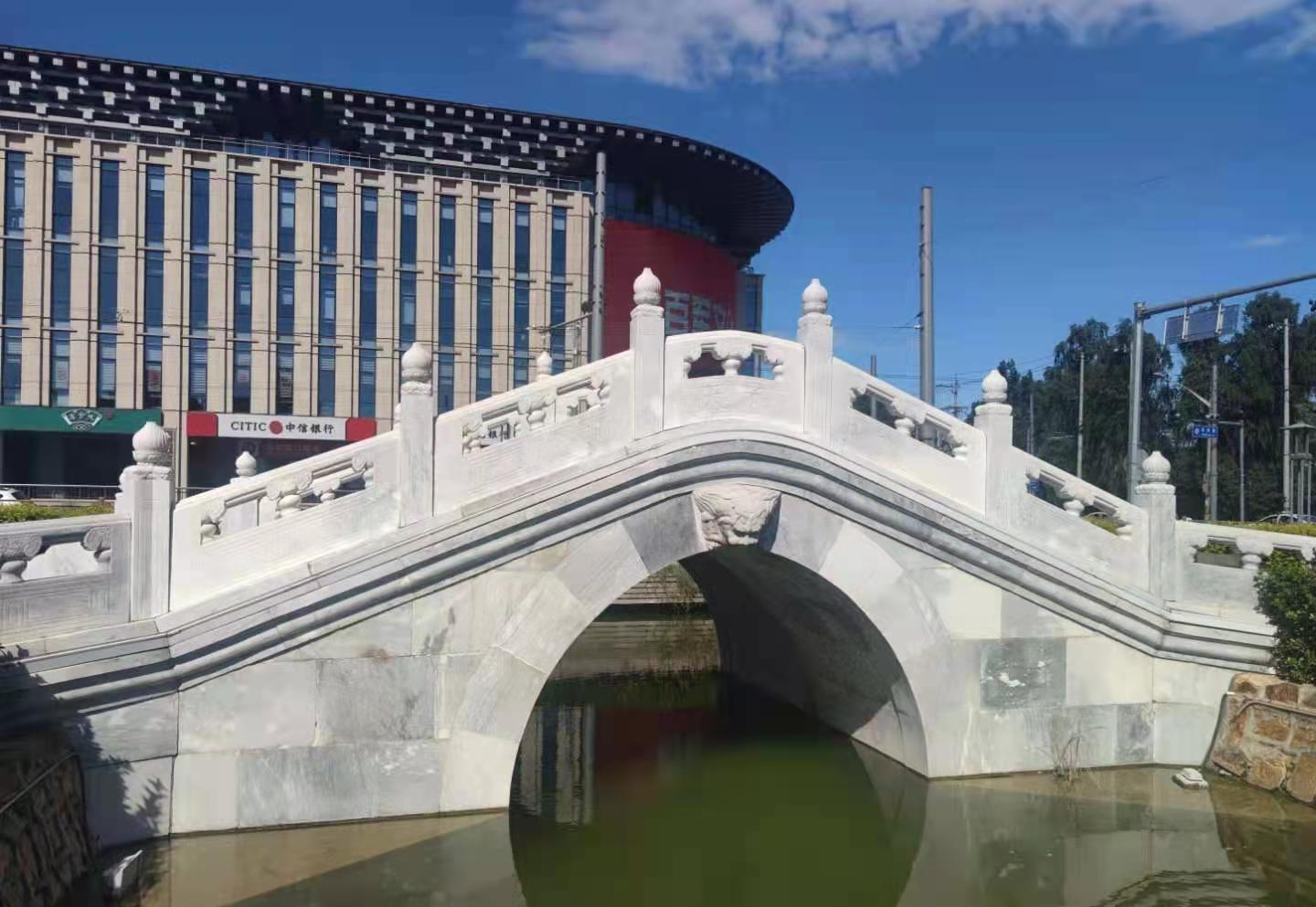
The existing landscape bridge is not in situ at the site
The central axis of Beijing, from the Bell and Drum Tower in the north, passes through Jingshan, the Forbidden City, Tiananmen Square, Zhengyang Gate, and the south to Yongdingmen, running through the north and south of the old city. According to historical records, the tianqiao was the only way for the emperors of the Ming and Qing dynasties to go to the Temple of Heaven to worship the heavens, hence the name. During the late Qing Dynasty, Tianqiao also developed a unique city culture, which became one of the representative areas of old Beijing's characteristic customs and folk customs.
Since the 1920s, after the transformation of the Longsugou nullah into a hidden ditch, the construction of trams, and the widening of roads, the overpass was finally demolished in 1934, and has been "in name only" ever since.
"In the middle of the green belt of Tianqiao South Avenue, isn't there a stone arch bridge?" Young citizens have this doubt. In fact, the Qingbai stone arch bridge, which was rebuilt in 2013, is a historical and cultural landscape bridge, not in the original site, and the landscape overpass is about 40 meters south of the original site, mainly considering traffic pressure and construction costs. The landscape bridge and the imitation double monument together constitute the tianqiao historical and cultural landscape square, evoking people's memories and nostalgia.
Existing landscaped sky bridge
The approximate location of the overpass is at the confluence of the four traffic arteries of today's South Avenue North Exit, Qianmen Street South Exit, Temple of Heaven Road West Exit and Yong'an Road East Exit. Can I locate the exact original site of the flyover? Chen Pinxiang, vice president of the Beijing Municipal Institute of Surveying and Mapping, has done relevant exploration before 2008 and is also the leader of the project of exploring the tianqiao site. "In terms of the technical level at that time, the accuracy could only reach about 10 meters, and it was far from enough to accurately locate the original site of the overpass." Chen Pinxiang introduced that with the continuous advancement of beijing's central axis heritage application, the relevant research and value mining of the central axis have also been deepened.
One horizontal and one vertical positioning of the original site of the overpass
Entrusted by the Beijing Municipal Bureau of Cultural Heritage, the Beijing Municipal Institute of Surveying and Mapping launched the original site positioning exploration work this year.
According to archival records, the flyover is located on the Longsu Ditch. Therefore, the original site of Longsugou needs to be located first. It is understood that since the 1930s from the open channel to the dark ditch, Longsu Ditch "sneak" underground, with the urban changes, municipal road construction and other major changes, it is difficult to find the location at that time from the status quo; coupled with the dense underground pipelines in the area, it is very difficult to find the old pipeline.
"We specially retrieved the drawings and archives of the 1971 pipeline census, and judged which pipeline was Longsugou based on the initial steps of the pipeline construction in the archives." Dr. Zhang Yiran, a special class in the core area of the Beijing Institute of Surveying and Mapping, introduced that after superimposing the underground pipeline drawing archives with the historical image maps of the 1950s, the location of Longsugou can be basically determined. The north-south direction of the overpass is determined through the Longsu Ditch, the east-west direction of the overpass is determined by the central axis, and the point where the two lines intersect in a horizontal and vertical manner is the accurate orientation of the original site of the overpass.

The inspectors conducted an investigation of the overpass field pipeline
Can this testimony be corroborated with the actual situation? In May this year, the Beijing Municipal Institute of Surveying and Mapping conducted a survey of underground drainage pipelines in the tianqiao area. Wu Yao, an engineer of the Third Branch of Professional Surveying and Mapping, and his party opened nearly 100 manhole covers within the demarcated range and conducted downhole exploration through instruments. According to actual measurements, there are currently 3 east-west rainwater and sewage pipelines with similar locations in the Tianqiao area, "Judging from the overall situation of underground detection, judging from the construction materials, forms, new and old characteristics of one of the pipelines, this pipeline is more in line with the construction technology and conditions of that year, and it is the Longsugou water system." Wu Said.
At this point, the location of the original site of the overpass can be basically confirmed, 40 meters north of the current overpass landscape.
3D mapping provides data assurance
The central axis is the core of Beijing's urban spatial layout, and it is also the focus of protection and development in previous urban planning. Liu Hong, secretary of the Party Committee of the Beijing Municipal Institute of Surveying and Mapping, introduced that the Beijing Municipal Institute of Surveying and Mapping has set up a special class for the functional core area of the capital and an orange craftsman combat team, led by Yang Bogang, a master of national engineering survey and design, and Wu Runze, a craftsman of a big country, to carry out surveying and mapping geographic information services in the core area, including the application for heritage on the central axis.
In the process of exploring the original site of the tianqiao, the Beijing Municipal Institute of Surveying and Mapping also determined the spatial orientation of the central axis for the first time, clarified the spatial distribution of the heritage points involved in the application for heritage, and used VR technology to carry out the position detection and three-dimensional reproduction of the disappearing nodes of the central axis, such as the North Gate and the Di'an Gate.
"With the help of modern technical means such as satellite positioning, we surveyed and mapped the spatial location of the heritage points of the main buildings located on the central axis, and after the data fit calculation, we obtained the spatial orientation of the central axis in the sense of mapping." Wang Pan, dean of the First Branch of Basic Surveying and Mapping, explained that the central axis is the most important reference system in the north-south direction, and its accurate orientation can further verify and confirm the original site of the overpass.
On the 26th, the technical staff of the Beijing Municipal Institute of Surveying and Mapping went to xiannongtan and opened the prelude to the three-dimensional mapping of the real scene of the central axis. The infrastructure three-dimensional reality information database technology that has been applied in the Tiananmen area is expected to be applied to the management, monitoring, protection and display of historical and cultural resources of the central axis, promote the scientific management of the heritage of the central axis, and provide spatial data guarantee for the application for heritage in the central axis and the implementation of the control regulations in the core area.